
Lower Grand Gulch 2003
Shifting to Plan B
Back to the Arch
Friday, April 18
 There is a Chinese Proverb, once quoted by Ian Fleming, which loosely translated goes: "Once is happenstance. Twice is coincidence. Three times is enemy action." I am not sure who the enemy was this morning, but I do know that we were being used for a bit of military practice. Yesterday morning, we could hear what we suspected of being a military jet fly very close to us. Since the canyon is pretty narrow where we were camped, and the plane was flying low to the plateau surface, we had but a few seconds warning, and no one got a glimpse of it. Of course, we could really feel it fly over. Then, yesterday afternoon, an A-10 Warthog flew right over our camp, tilted on its side so the pilot could look down the length of his wing right on our campsite. This morning, some sort of swept wing fighter had flown in the same configuration, tilted so he could see our campsite. It was clear that we were being used as practice for locating a target in a very tight spot. Probably being guided by some AWACS plane. I did not really mind, but it is always a bit unnerving, knowing you could be a target.
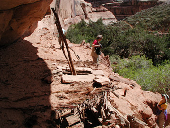
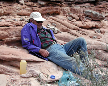
Despite the noise for a few seconds, it was a pretty quiet morning. We rolled up camp at a pretty relaxed pace. First, the temperature was in the low 40's and secondly, our goal for the day was only about 4 miles upstream, the north side of what the topo maps refer to as Shaw Arch. We did have one "official" stop: Sue had checked her notes and recalled that a few miles upstream, there was a collapsed kiva in one of the rincons that was worth checking out. Of course, there was always photographing to do. We did find the kiva, and it is always worth a stop: the front of it has collapsed, but much of the roof is still intact, making for a good lesson in Anasazi construction techniques. Since we had started late that morning, it was not too long before lunch was in order. It was the first time on the trip that the entire group of seven had lunched in the same spot at the same time. Ray mostly relaxed during lunch, and we all kidded him that he was posed as if in a clothed Playgirl magazine shoot. We called him The Canyon Stud. He certainly looked like one, even though he was the senior member of this trip.
 Our after-lunch walk was punctuated by a couple of near misses. Susie and I, hiking by ourselves, were coming off a steep bench. I was faced into the rock, descending gingerly, when my hand hold broke loose. As I dropped just a foot or so to the next bench level, I staggered backwards, and managed to get myself stopped before I did a reverse swan dive off the next 6 foot ledge. Good way to get your adrenaline pumped up. Then later, Susie decided she would check out a spot where a log had been jammed into the side of a slot. She was able to get up just fine, but forgot the great lesson of canyon exploring: It is always easier to go up than to get back down. She started freaking out just a bit because of the exposure, so I had to go up and act like a foot jam in a couple of key spots. Hey, what are husbands for, anyway?
Despite the relatively short stroll up canyon, it was still good for over 4.5 hours. Just too many photos to take. The Arch area is one of those spots that has seen a dramatic improvement since the cows were kicked out of the canyon a few years ago. The grass is back to the point where there was little interest on the part of our folks at camping on the "upper level." Just amazing. Since it looked like we were in for a blow and maybe some rain, Susie and I quickly set up the tent and got our gear protected. We stayed pretty close to camp for a while, taking in all the pictographs on the arch, and the metate (corn grinding area) at its base. But then, the black clouds blew through, and it was time to go exploring. 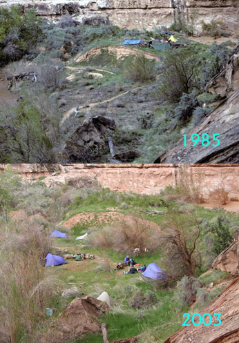 Number one on our list was to investigate the infamous pool that Ray and Will had to negotiate in 1985 to exit the canyon. On that trip, seemingly thwarted in their attempt to see Slickhorn by the difficult terrain separating the two canyon mouths, they decided that they would hike up canyon, and exit via the canyon that flows into Lower Grand Gulch immediately to the south of the Arch. They could hop in the van parked at the drill hole and drive to the head of Slickhorn. (Apparently, on our way down canyon in ‘85, Will had explored up this canyon and had reason to believe an exit was possible. That said, he also asked to take the community rope - 50 feet of goldline - to hoist packs.)
Susie and I decided to head up the canyon, the lower end of which is lovely in its own right (12S, 571941E, 4135454 N). Slickrock slabs in some locations and flowing water. We did not get more than 400 meters or so, when we came upon Ray sitting with Barbara at the bottom of a seemingly show-stopping rockfall that must have been 150 feet high. "I just don't remember this rockfall," Ray said. "Could this be the wrong canyon?" Well, since Will had not joined us on this trip, I had to assure Ray that yes, this is where they exited from. Of course, rock falls happen all the time. It would not be surprising if one had occurred in the last 10 - 15 years. Well, we stood around and chatted for a bit, but then Barbara, in her typical "The Lord hates a coward" approach to life, took off, and started picking her way up through the rocks. Ray, looked at me with a sly grin on his face and said, "Hey, I don't want anyone crawling up through those rocks by themselves." and took off following the route she had chosen. Susie and I looked at each other when Barbara yelled back down that the going was not too bad, and said, OK, no more excuses, and took off in pursuit. Barbara was right, picking ones way up through 150 feet or so of boulders was not too bad on the left side of the slide, and by the time we reached the top, she and Ray were out of sight around the bend. I thought to myself: "Yeah, this rock slide has been here for at least 18 - hundred - years." 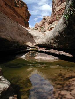 We rounded the bend and came to Ray's pool, which is surely the crux of getting out of the canyon at this point. Ray explained that it was all coming back to him now. They had climbed the rock pile and reached the pool. Will, the more experienced of a rock climber between the two of them, and walked the ridge of sand in the water and had managed to use the existing cracks below the lip of the pour off to get up on the ledge. He then friction walked a steep incline and dropped a rope line to Ray, who was on solid ground. Ray tied the packs on the rope and Will hoisted them up about 20 feet. Will then came back down and helped Ray get up the lip. So, here is another way to enter/exit Grand Gulch at this point HELLO!!! BLM!! Are you reading??? Can you spell A-D-V-E-N-T-U-R-E P-E-R-M-I-T???
Ray reports that the rest of the route is easy. Sure, it is still 4 miles or so back to the drill hole, but the going was smooth, and this is surely another spot for which the BLM should consider reversing their overly restrictive permit policy. Ok, off my soapbox, and back down the canyon. Readers should note that there is a small (4 ft diameter by at least 4 ft deep) pool in the upper part of the lower drainage. The water was cold and clear and I just had to take a drink. I think it was the only time on the trip that I had drunk untreated water, and it was wonderful. (No, I never got sick.)
The clouds were starting to build again as Susie and I took our bath. Wind picked up and the temperature started to fall. By 5:30, the clouds started to dissipate. Ahhhh, another good sleeping night. After dinner, we all sat around and talked, until it got so dark we could barely see. Another great day in Canyon Country.
© Roger A. Jenkins, Suzanne A. McDonald, 2003