
Lower Grand Gulch 2003
Shifting to Plan B
Shangri La
Wednesday, April 16
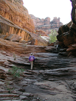 What a great day. We woke to mostly clear blue skies. The very thought of not having to move camp for TWO WHOLE DAYS was extremely appealing. After a light breakfast, we all headed upstream and into Shangri La Canyon (all at different times, of course). Susie and I held our traditional spot at the rear of the pack. I remember Shangri La being lovely from the short time I had spent there 18 years ago, but I had forgotten just how delightful it really is. After climbing up through a couple of easy pour offs, we got into a long stretch of slickrock. As the canyon makes its first 180 degree bends, I noted from a scrawl on my 1985 map that a side chute at12S, 571369 E, 4131350 N is supposed to offer an exit route. We never explored this area in any detail, but it did look like a possibility. Maybe if the BLM ever starts issuing more interesting permits, this route might provide for a possible entrance into LGG. However, it should be noted that the head of this canyon is several miles (at least 5) from the nearest vehicular pathway, and that is a 4WD route.
Susie and I spent a lot of time photographing the lovely scenery as we progressed up the canyon: large slickrock slabs, nice pools, and shear canyon walls. About a mile up the canyon, you come to the confluence of the North and South Forks of Shangri La Canyon. Well, it isn't quite a confluence. Rather a junction if you can think in three dimensions. The North Fork of the Canyon, when viewed on a topo map, is obviously the longest route, having come nearly 5 miles from the aforementioned 4WD road. The topo map shows the canyon as having a pretty shallow slope toward its confluence with the south fork. Except for the last couple of hundred feet. And then it goes straight down. Like a sheer wall. Maybe a canyoneering crew could make it, but one would need a lot of rope. For all intents and purposes, the route in is a non-starter for most hikers and backpackers. One of the many reasons why they call this Shangri La Canyon. Lovely and very inaccessible.
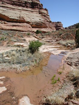
Another two-thirds of a mile up the canyon, we came to a real fork. Sue would later refer to this one as the North Fork of the South Fork of Shangri La. The canyon bottom was dry at that point, but I went up the stream bed (of the NF) just a little ways, and found water flowing. I took this as a good sign, and suggested to Susie that we head up it. We were treated to more slickrock slabs, and running water for quite a ways. We eventually worked our way up to a spot where the stream sort of meandered through an area that looked like a filled in marsh. Lots of tall grass. We poked around on the south facing canyon walls, and found some pretty dilapidated ruins, and a few corn cobs. We were both hungry, so we decided to turn around and go back to a spot where there was a nice slickrock bowl to eat lunch. Susie said it reminded her of the Enchantments (mountain range in the Central Washington Cascades). I did not see the connection, but hey, whatever it takes to keep a positive outlook. Lunch was "interrupted" by the rest of the crew coming up this Fork. They reported that they had all been to the head of the South Fork of the South Fork, and there was no way out. More confirmation that the canyon name is apropos. We pointed out the set of ruins to them and headed back toward camp. It was still pretty early, but we wanted to see if we could get up to the so-called Perfect Kiva that is within walking distance - sort of - of camp. On our way back down canyon, we came across one of these helium-filled balloons that Wal-Mart uses to advertize their sales at various stores. It was wedged between a rock and a bush, out in the middle of this lovely canyon. Really hacked me off. 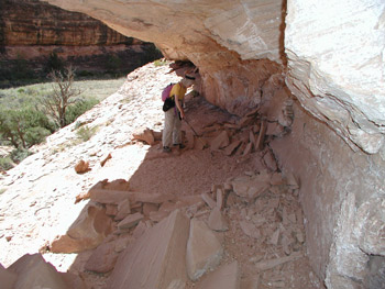 Sort of random littering at a distance. The balloon probably escaped from one of the sales in Las Vegas, St. George, Cedar City, or Page. It literally must have run out of gas, and drifted into this wilderness area. I picked up the balloon remnants and plan to send them to Wal-Mart's President and CEO, reminding him that if it would have drifted just a bit further, it would have ended up in a ruin, and as such, under Federal Law, would have to be considered a violation of Antiquities Act. Probably will not do any good, but it can't hurt.
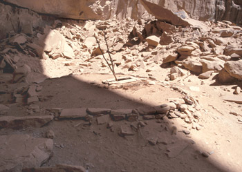
After breaking out into the main canyon (LGG), Susie and I headed off to find Perfect Kiva. My memory was a bit foggy, but Sue's notes had been pretty good and Art Johnson had confirmed those. Yeah, it is a bit of a hike, but it was really neat to see such a ruin with the roof completely intact. It is under a huge alcove, probably big enough to house part of a football field. There were the requisite pottery shards, and the vertical members of the ladder down into the kiva are still intact. (Obviously, we are being fuzzy as to the location of this ruin. You can find it on your own - I did the first time I was in the canyon - and that way, you will have your own adventure.)
 Back in camp, it was time for bathing. Susie had planned on having a hot bath, using water warmed in the water bag and placed in the sun all day. She was not disappointed. Judging from the ooohhs and aahhs up and down the creek, sounds like several others had the same idea. The rest of the afternoon was spent relaxing, chatting, eating snacks, reading, and waiting for dinner time. It felt really great not to have to do anything, secure in the knowledge that we did not even have to move camp for another 40 hours or so. It was feeling like a real vacation. After a dinner of Uncle Bens Cajun Rice and Beans, fortified with dried ham, that Susie thinks is way too spicy, the evening was filled with more chatting, and listening to a frog serenade. Life was good in the canyon.
© Roger A. Jenkins, Suzanne A. McDonald, 2003