
Moqui Canyon/North Gulch Loop - 2002
"Terra Incognita"
The water runs out - sort of
Sunday, April 21 We awoke to sun, with frost on our pack covers, and partially frozen boots. But maybe the cold would keep those infernal noseeums that plagued us during dinner at bay. I noted that there was more water flowing in the creek than there had been in the afternoon. We, who really know nothing about such things, attribute it to the evaporation-transpiration cycle: we think the trees, and warm ground itself, suck up water during the day. At night, there is not as much pull on the water, and the creek flow increases. We are talking here about of change of maybe 20% or so, but on a trickle, it is noticeable. Budding hydrogeologists, I guess.
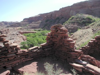 We discussed our plans at breakfast. George's was pretty straightforward: leave this camp soon, and hike to the next camp. With only 5 miles or so to hike to the next camp, the rest of us decided to engage in various levels of exploring, mainly looking for more ruins. The two married couples decided we would head back downstream and try to find this sentinel ruin that the rest of the group had raved about. Will had given us his GPS coordinates. He was visibly proud that he can now take a waypoint, and save it, and actually provide it to fellow hikers. He still did not have actually naming the waypoints on the GPS figured out, but for that, there was his trusty notebook. The GPS reported that the ruin was 0.62 miles away. Since this was a fairly straight canyon, I used the 150% rule for estimating actual walking distances. That is, take the straight line distance, and figure you will have to walk 50% further. It turns out that, based on a tracking measurement, the real walking distance from camp was 0.92 miles. It took us only a bit over 20 minutes to get to the ruin. It is easy to see how we could have missed it when we were in the vegetation. The ruin sits on a point, perhaps 50 - 75 feet above the stream bed. It was also easy to see why the Anaszi picked the spot: It had a commanding view of the canyon, both upstream and downstream. The ruin is near 540497 Easting,4145763 Northing, and has a few smaller ruins associated with it. Susie and I headed back when we had our fill, but Sue could not resist lingering.
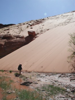 We were back in camp and hoisting by 10:50 am, ready to move up canyon. The walking was pretty easy, as these things go, and we had made 1.4 linear miles when we stopped for lunch. We had passed another huge sandslide, that nearly blocked the creek. The canyon walls on the south side are about 500 feet high, and these sandslides offer a way to get in or out, albeit with a tremendous energy expenditure. I can not imagine having to climb up one with a full pack. You would step up 6 inches and slide back 5, I think. Susie and I stopped in some broken shade for lunch. With the light breeze, one would quickly chill in full shade. We could hear voices, one of which was Will's, all thoughout lunch. But we could not figure out from where it was coming. Upon finishing lunch, we saddled up (feeling always a bit like pack horses) and walked about 400 meters, and found Will and Diane just getting up from lounging in the sun. (I guess they called it lounging, anyway.) They indicated that they could hear virtually all of our conversation at lunch, from nearly a quarter mile away. They were directly across from this huge overhung wall that apparently was capturing the sound and focusing it on the spot where they were "lounging." Sort of a canyon version of these gigantic radio telescopes.
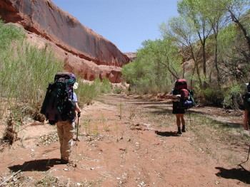
As we moved on, and passed more 500 foot high sand slides, we noticed that the water in the creek bed was getting cloudier than we had seen previously. We soon came to a side canyon that had a lot of sand-laden water flowing out of it, probably due to sand slides in its upper drainage. In fact, a crude estimate would have been that 2/3 of the water flowing down canyon was originating in this side canyon. Several of us got some water, because we all knew that it could be dry very quickly. Susie and I moved up canyon, shifting between the stream bed and the benches, and suddenly, it seemed as though the water flowing in the stream bed stopped. I stopped too, and turned around, and surveyed the situation. I looked back and could see some water flowing in from a little side drainage. I walked over, and could see that one small spring on the south side of the canyon, at 545523 Easting,4147524 Northing, was supplying the total water flow for the canyon. Susie and I rested in the shade for a bit, and had a bite to eat, and as other members of the crew walked by, we alerted them to the situation. As we started moving again, the trees seemed to disappear, and we were left in an open, dry canyon. In another 1.2 miles or so, we got to the spot where I had suggested for a campsite. The reality of the place - big, open, hot and bone dry - was something I had been concerned about, ever since I had learned that Southern Utah was experiencing a drought.
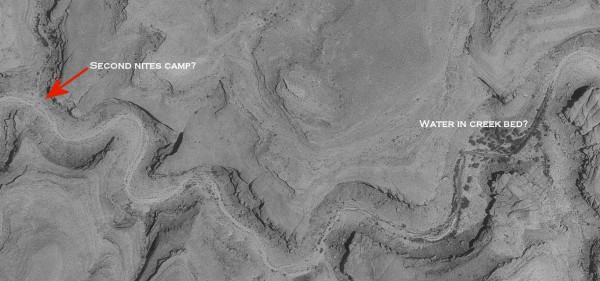
 Now I would get the chance to see if all that time studying aerial photos was worth anything. A sidebar here. One of the really wonderful resources that the State of Utah makes available to the world is its GIS Data Site. This site has tons of data such as scanned topo maps (called digital raster graphics, or DRGs), digital elevation models [they have been having problems with the high resolution versions (10 meter), but their 30 meter ones seem to work fine], and perhaps best of all, digital ortho photo quads. DOPQs are essentially aerial photos of the same quad coverage as a topographic map, and they are a truly exceptional resource. They also can be, depending on the horsepower of your internet connection and your computer, a challenge to work with. For example, the DOPQs are black and white jpg images that run 25 - 30 MB each. That size download can be a real adventure if you have a 28 Kbps modem connection. In addition, many of your standard bundled software programs (such as the Photo Editor that is bundled with Microsoft Office) can choke on a jpg that is that large. However, the "real" photo editing programs, such as PaintShop Pro or Ulead PhotoImpact don't seem to have a problem. But you can really "feel" the capabilities of different computers when working with these sized files.
Anyway, I had studied the DOPQ that covers the area around our potential campsite, and was concerned that I did not see any of the telltale dark gray in the streambed that would have indicated water. However, upstream about a mile and a half, I could see the dark gray in the stream bed and trees on its side. A careful, post trip examination of the photo shows a trickle extending for several hundred meters downstream of the trees. I did have the foresight to print out this part of the photo and stick it in my map pouch. And had showed it to George last night. Since he was not at the spot that I had originally designated for our campsite, I could not be sure of what we would find, recalling I had no clue as to what year that the photos had been taken. But I did know that as the afternoon heat built up, Susie was starting to drag, and it was a good excuse for a rest break. I told her I would go up ahead, and see if George had found a place with water. Since the "alternate site" was not exactly just up the street, I knew that my reconnaissance would potentially add 2 - 3 miles to my day, but it would give an opportunity for Susie to take it easy (there was a big rock that would provide shade, but she insisted on checking out the side canyon that came in to the north near that spot) and for the remainder of the crew to catch up. (Susie ultimately reported that while there were a few trees in the side canyon, she could not find any water before she reached a huge chokestone that blocked further passage for the less than 100% ambitious traveler.) I took off, crossing the sandy benches as fast as I could, feeling like I was flying since I had temporarily dumped the load I had been carrying all day. As I hiked, I noticed that there was a large cairn near the obvious lowest energy trajectory I was following. (It is hard to call what I was walking on a "path", since there were so many cow paths around.) Since there was a possibility it held a note that might be from George, I examined it closely. As it turns out, there appeared to be a "NOLS-like" group ahead of us, by part of a day or so. They even had an "official" pad of Cairn Notes, designed to provide detailed information to those following. They apparently were headed for Harrison Spring that evening.
As I got a little over a mile above where we had stopped, I could see wet sand in the creek bed, and my spirits soared. Before long, there was real water. Even more than a trickle. I looked around, and still no George, so I continued across another bench, and could see around the bend, in the distance, a grove of large cottonwoods. There was still plenty of water in the stream bed, so I decided to quit my hunt for George, turn around, and get the gang moving up here. I had no water with me, and no capability for treating any, and it felt like a long way back to my water bottle. I hurried back down the canyon, timing myself from where the water started/stopped to our rest place. It was 20 minutes. By the time I arrived back where Susie was, the remainder of our group had shown up. I enthusiastically reported that while I could not find George, there was water only 20 minutes up canyon. Ray muttered something about that meaning it would "only" take us 40 minutes with our backpacks on. Susie took off, and I am told that she was moving so fast that no one could catch her. I stopped for a rest, drank some more water, and munched on some M&M's. With this many people depending on my planning, it felt good to be right.
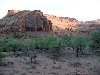
As it turns out, it was but 1.4 miles to camp, depending on how much you cut off on the benches. The spot was right across from the mouth of Burnt Spring Canyon. George was waiting for everyone there, under huge cottonwoods. (I pulled into camp at about 4:20 pm, or about 5.5 hours to go 6.25 miles. A typically speedy day in Canyon Country.) I asked, why, when I yelled up the creek for him, he did not respond. He indicated that maybe he had been up in the side canyon gathering water at the lovely spring he had found. Whoa!! Apparently, I had not spent enough time studying the maps and photos: there is a very nice spring about 100 meters up in Burnt Spring Canyon, right at creek bed level. So not only did we have water in the stream bed, we had spring water (albeit most of the folks chose to treat it anyway) for drinking. A veritable Garden of Eden. OK, due to the damn cows, there was no grass at our campsite, just dried cattle dung and cottonwood leaves under the trees, but there was lots and lots of nice spots to put up tents, and everyone seemed to quickly find their own private part of the bench. Our group looked like we had been outfitted by Sierra Designs. On this trip, every tent (all 7 - for 10 people) was Sierra Designs. There was Will's new LookOut 2.0 (admittedly, SD really screwed this tent up when they redesigned it, making it taller, and added another door, another tiny vestibule, and this nonsensical zippered "window" that you can actually poke your head out, all contributing to 24 oz of totally unnecessary weight. There, I have said it, and I am glad), several Clip Flashlights ("2" and "3" person units) and Barbara's barely-more-than-a-bivy-sack Light Year. Several folks said we ought to photograph our camp and send the photos to Sierra Designs. Maybe we could get a free tent for testing. I indicated I would wait until they came out with version 3.0 designs, and stripped off some of the unnecessary weight.
 Susie and I put up our Clip 3, and she took off for a bathing spot. After I staggered around a bit, I went down to join her. At dinner, I talked with George about what went through his mind when he got to the place where we were originally supposed to have camped, since Will had complained about George not having waited for the rest of us when he got to the original spot. George explained that he was only following the plan: go to the waypoint marked as the second camp. If there was no water, based on the aerial photos, Roger had said to go about a mile and a half upstream to where there probably was water. George said that when he saw the cairn note from the NOLS group, he was a bit crestfallen. It was obvious that they were headed for Harrison Spring that afternoon, which may have suggested that there was no water between where the water ran out a few miles back and Harrison Spring, which was still several miles up canyon. However, when he reached the wet sand in the creek, and saw real water, he said, "Damn, Roger hit it right. There is water here." Of course, there was incessant ribbing about a) how I had gotten lucky and b) if I was so good at reading the aerial photos, how come I had missed the topo map indicating a spring in lower Burnt Spring canyon. That was OK, since I was getting a belly full of beef stroganoff for dinner, the moon was rising, and although the noseeums were also dinner guests, with unlimited water, I could continue to keep a wetted bandana on my head and throw off the thermal sensors of those confounded little gnats. As George is always so fond of saying, "Is this a great country or what!!"
© Roger A. Jenkins, 2002