
Moqui Canyon/North Gulch Loop - 2002
"Terra Incognita"
The final two miles
Saturday, April 27
 Yeah, it was a rough night. The wind howled off and on. There had been little rain, but I worried about how the tents, designed for gentle breezes (with the exception of Will's LookOut), would hold up. Our Clip 3 had done great on the summit of Big Frog Mtn on the GA/TN border two weeks before we left for this trip, but the wind seemed worse here. We did get a bit of rest when the wind died out for a bit, but it picked up again 1am, and we slept fitfully. Probably in the back of our minds was some bit of concern that the Captain Jack would have a tough time getting across Lake Powell from Bullfrog if the wind did not taper off some. Anyway, the wind quit pretty much altogether by 6 am, and so we rose a half hour later. I had gone to bed in my hiking clothes, a pitiful attempt to compensate for the glacial pace at which I stumble around most mornings on the trail. Susie shook out our sleeping bags, and that got some of the sand out. No community breakfast this morning: we fired up our stove near the tent to make a spot of coffee while we packed. We wanted to be moving by 8 am at the latest.
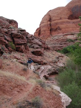
Our "scouts" had figured out that the key to successfully negotiating the remainder of the route to the lake was to stay out of the brush in the creek bed as much as possible. We climbed up on a bench on the north side of the canyon and stayed on that as much as we could. Climbing back down was required after a while, and we decided to stay in the stream bed. That worked for a few hundred meters, and then it was time to climb back up on the north side (right down canyon) bench. The topo maps all show the lake level at 3700 feet elevation, but it is clear it has been many many years since it was that high. A check of the historic levels of Lake Powell suggests that the summer of ‘96 was the last time it was anywhere near full pool level. For our trip, the lake level was about 3645 feet. Interestingly, just a few feet of depth loss makes a huge difference in the degree to which the reservoir is "full." At 3645, the Lake only holds about 2/3 of its maximum volume. Anyway, the impact of the lake being down really hit home as we were pushing through some heavy tamarisk and head-high cockleburs. Sue had alerted us to look for a tall drowned cottonwood trunk that had an obvious mooring rope tied to it near the top. It was interesting to see this, perhaps 20 feet or so over our heads. Given the state of the vegetation, I was wishing that Southern Utah had not been experiencing a 3 year long drought, and that all this invasive plant life would have been drowned. But all things must pass, and by climbing up on the bench, we were able to avoid the remainder of the unpleasant vegetation. We had finally arrived at what one might call the "lunar zone," the region where the lake has receded but where there has been insufficient time for any re-vegetation to occur. A lot of folks think deserts are pretty much waste land, but in fact, there is all kinds of stuff living and growing. However, not on this stretch: just formerly drowned terrain. The one saving grace was that the walking was easy.
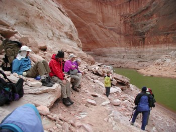
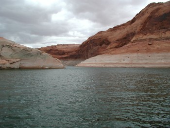
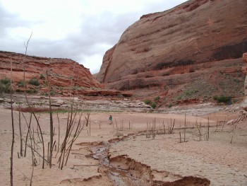 We could see the lake backed up into a small cove, and I knew we were just around the bend from the pickup spot. I noticed two young boys - the first non-group humans I had seen in a week - on top of a small ridge, right above a ledge where we would have to walk to skirt the water. They were throwing huge rocks that were crashing down on the trail. Susie was ahead of me perhaps 150 meters or so, and I was concerned for her safety, although she could hardly miss the potential danger from all the noise of splitting boulders. Fortunately, the father showed up and yelled at them and told them they were endangering other people. Geech!!!! You survive a week backpacking in these canyons, only to get your head caved in from some kid who is totally unaware of the potential consequences of his actions. Anyway, by the time that Susie arrived at the "drop zone," the kids had taken off, endangering some other poor species somewhere, no doubt. We turned the corner, and were welcomed back to civilization by a bass fishing tournament. Susie and I pulled into the pick up spot at a bit after 9:30. The air was still pretty cool, but we did not have to wait very long. About 10 am, a big houseboat pulled up with Captain Jack at the helm, and our backpack was over. We noted that, judging from the cairn we had placed, the lake had dropped a foot over the course of the week. The wind and the water skiers and bass fisherman zooming about the narrow confines of North Gulch inlet made for some tricky maneuvering, but once we were out, the Captain let Sue take the helm, under his very watchful eye, of course.
 We pulled into Bullfrog a bit after 11:30, thanked Captain Jack (with a handshake and a tip) for his prompt timing, and piled off the boat. The incongruity of the view that was next left a big impression: here were these folks, mostly nattily dressed, wheeling these carts full of houseboat gear down to their covered slips. They all looked clean and neat, and the stuff they were wheeling did not seem too critical to their survival. Headed the opposite direction was our group. Dirty clothes and gear that had been blasted by a week in the field. Sorta looking like a bunch of marines returning to base after a battle (ok, two of our group were ex-marines and another a West Point grad, but that was a long time ago). The contrast was pretty stark. Anyway, we piled into the vehicles and made a beeline for the A&W in the gas station just across from the Dry Land Marina, north of Bullfrog. I guess 1.5 lbs of food per person per day just only goes so far.
Epilogue and Summary
I rode back to Salt Lake with Andy and Sue, reviewing the maps with Andy for our upcoming Beartooths backpack. Just like 8 days previously, it was snowing as we went over Soldier Summit. We met up with the van and the rest of our crew in Provo, and decided to eat in Provo rather than going on to Salt Lake. After stopping in a couple of places to ask folks where to get good Mexican food in Provo, we settled on Los Hermanos. It is a real deal place, and the combination burrito (chicken, pork, and beef) was pretty good. However, we were plagued by slow service again. I don't know if was just the grizzled appearance of our crew, or maybe the fact that we wanted evil beer with our meal, but being fed was a slow operation, even at an early hour. The flights back the next day were pretty uneventful. Except that ours from Cincinnati was cancelled. Fortunately, Susie and I and Geroge and Barbara (Will took an early flight back with Diane on standby) were able to get on the next plane, but poor John did not get home until after midnight. Of course, since he is a RETIRED history professor, it probably did not make too much difference.
 Some thoughts about the Moqui Canyon/North Gulch complex. First, we went the entire trip without seeing any other humans. From a solitude standpoint, this rivaled our first trip to Dark Canyon in 1983 (NOT the one in 2000) and in Upper Paria Canyon in 1994. It is good to know that there are still places left in the canyon country where you can find that degree of solitude. Second, the route we did certainly can be done much faster than we covered it. You can also go to a banquet and try to finish dinner in 10 minutes. This canyon complex is at a lower elevation than many others we have done, and how much distance you feel like covering may depend a lot on the heat of the afternoon. You could probably do the entire trip in 4 to 5 days if you are in a hurry. But such won't give you a lot of time to savor the scenery, explore side canyons, or commune with your friends. Third, prior to this report, there has been very little information on this area. We hope that many of you who are looking for something different will give Moqui a try. There are not the permit hassles of the canyons on Cedar Mesa, just a few miles to the east, yet in some respects, the scenery is comparable. Fourth, of the two canyons, North Gulch was more interesting. The soaring vertical walls are something to behold, and in some ways, remind one of Zion - without the theater at the entrance, the bumbleberry pie signs and the hoards of people searching for a parking space. North Gulch is a much tighter canyon, due to the elevation that it loses over its 12 mile run to the Lake. The gradient is steeper than that of Moqui, and because of such, there are few big benches. But the hiking was really not difficult, and I think nearly any experienced backpacker would call this an easy to moderate trip. Fifth, in some respects, the Moqui/North Gulch complex is a poster child for what poor land managment and government subsidized grazing can do to a place. The impact of cattle is hard to get away from, and in lower Moqui, we found ATV tracks. So I would encourage you to write the BLM and the Glen Canyon National Recreation Area. Let them know that this is too valuable a resource to continue to desecrate it in the way in which they are doing. But be hopeful. Removing cows and vehicles can bring quick relief for a canyon. We saw that last year in Grand Gulch. In 1982, there were very few grassy stretches in the canyon; the cattle signs were all around. In less than 20 years, the area had made a remarkable recovery. I was astounded by the changes. With hard work and a bit of luck, perhaps your kids can enjoy this area the way Mother Nature intended. Finally, I think the success of the trip is a good example of what one can accomplish with careful planning. Studying the terrain on maps and digital orthophoto quads (aerial photos) really helped, and provided us a degree of increased confidence without diminishing the sense of adventure. In these days of liability waivers and permitting requirements, it was really great to just show up at a spot and start hiking. Good luck.
© Roger A. Jenkins, Suzanne A. McDonald, 2002