
Moqui Canyon/North Gulch Loop - 2002
"Terra Incognita"
The wind and the beaver ponds
Saturday, April 20
 The wind that blew dust across the parking lot the night before had turned into a near gale as we awoke. The sky seemed to be clearing, the temperature was 40 , and there was a car in front of Andy and Sue's room, so I suspected that all the chicks were finally in the nest. The plan was to hit the Slickrock Café just when it was opening for breakfast at 7, and be rolling down the road toward Bullfrog Marina by 8:15. Yeah, in your dreams, Fleishman! The Café is strategically located within sight of the junction of Highway 24 and 95, mainly across the parking lot from the motel. George and Susie and I walked in right at 7 am, just ahead of two locals, and I got the immediate sense that we were a couple of hours early. Soon, the rest of the crew came in, along with a few more tables of travelers. It seemed clear that the one waitress was in way over her head. We felt sorry for her, but got to the point where we were practically banging on the tables for our food like a bunch of convicts. The food was great, but don't be in a hurry.
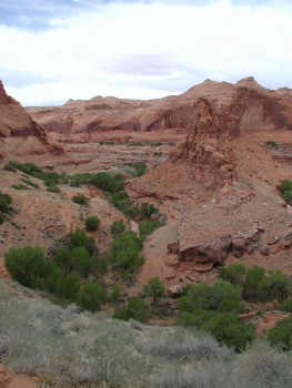
Buffeted by the wind, we headed down Utah 95, past the turnoffs to our 1988 hike on the Dirty Devil River. So much water under the proverbial bridge since then. George had to drive slowly and cautiously, because the van is such a high profile vehicle. There was a lot of discussion regarding a recent 60 Minutes expose on the tendency of Ford 15 passenger vans to roll over easily, especially when they are loaded. But after all these years with George driving the big vehicles, I have mucho confidence. Except perhaps for that time in ‘95, driving down Hole In the Rock Road in the mud........ But that is another story. Anyway, as we turned off UT 95 on to 276, and wound in and around the heads of these canyons, I could feel everyone's excitement when we could see a trace of water in the stream beds. We all knew that Southern Utah was three years into a major drought, and that water in these desert regions can be a chancy thing, even when we chose the season with the greatest guarantee of water (spring) due to snow melt runoff. Of course, one has to have snow to have runoff, and frankly, the tops of the Henry Mountains, the last mountains "discovered" by whites in the lower 48, were pretty gray looking. Not much snow to generate water. Our first glimpse of Lake Powell on this trip verified some of my concerns: whitecaps on the lake.
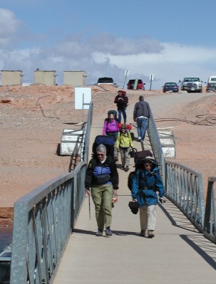
After a brief stop at the Visitor's Center, we headed for the covered boat slips to find Jon Coulter. In a way, Jon was really the key to this trip. Turns out that Jon used to be a boat dealer in beautiful Vonore, Tennessee, so we sorta considered him a long lost cousin. Jon is with Executive Services, a branch of the Prime Concessionaire on Lake Powell, Aramark. Executive Services operates as the name implies: they seem to do stuff out of the ordinary. Jon indicated that he and his team often picks up kayakers coming down the Escalante River at spring flood. Whew, talk about a car shuttle!! Anyway, with Jon's help, we could not have done this trip as planned, since we needed a boat to drop the ten of us off at the high water mark in Moqui Canyon today, and pick us all up a week later at the high water mark in North Gulch. Even though the drought had markedly dropped the lake level, it was not down to the 1992 level when the confluence of Moqui and North Gulch was not flooded. As soon as we pulled into the parking lot, I leaped out of the van (we were running 5 minutes late at this point) and went down to find Jon. I walked into his office, shook his hand, and we immediately got to the business of getting under way. Captain Jack, our boat pilot (think Alaskan bush pilot on the water, with a much larger plane), walked into the office and asked if those folks had shown up yet. It was clear that they were ready for us, and I suspect some of the impetus to step right on out had to do with the wind on the water. Captain Jack ("You can call me by my first name: ‘Captain'"), I am certain, was concerned about maneuvering the 42 foot houseboat that they would use to transport us in the tight canyon mouths. Wind tends to build up as the day warms up, and it was pretty evident that we did not need any more wind. After paying Jon, I headed back to the vehicles and told the crew we needed to rock and roll. No time for screwing around. I think within 20 minutes or so, all the packs were on the backs, and being walked down the ramp. We signed the manifest, identifying each person and associated emergency contact numbers, and we headed out across the bay.
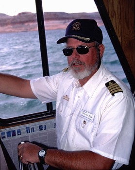 Captain Jack had brought a couple of friends with him, mainly because none of them had been up into the mouth of North Gulch, and they thought a bit of reconnoitering was in order. Ray seemed to like the idea of checking out North Gulch himself, since he was not completely certain that we would not have to rappel off a huge pour-off to get back down to the lake. The boat ride across Bullfrog Bay, up the main channel a bit, and into Moqui was a bit ironic for many of us who have railed on for years about the Lake Powell Bathtub. We all hate what it did to Glen Canyon and all the associated side canyons and archeological sites. We probably all wish the dam had not been built, but all were happy to use the lake to get us where we wanted to go. Probably we are not much different than the residents of Escalante, who are bitter over the designation of the Grand Staircase-Escalante National Monument, but are happy to sell the tourists and backpackers gasoline, and food, and t-shirts, and postcards, and guiding services. The world changes, and some things are just out of your control, and you can look at your glass as half empty or half full. Nevertheless, the trip across the lake was interesting, although given the weather (temps around 55 and high winds), the males in our party were probably pretty disappointed that their chances of seeing one of the nude photo shoots for which the Lake is so famous were slim to none. Since we had a good "tail wind", the houseboat seemed to do pretty well with its load, and it was less than an hour until we entered the main channel of Moqui, and probably another 20 minutes until we entered North Gulch. There were several boats near the high water mark, and Captain Jack pulled into shore so we could take a brief look around. Ray and Barbara headed around the bend, to get a look at the full canyon mouth. Several folks put up a rock cairn, to see if the water level would rise or fall in a week's time, and the techno-weenies among us took a waypoint so we would know where the trip would actually end. With the wind blowing at a good clip, the Captain turned us around in a tight spot, and we headed back to the drowned confluence of Moqui and North Gulch.
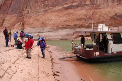 It was not very long after turning the corner and heading into Moqui that we ran out of water, so to speak. Captain Jack looked out, and headed full on to the beach, trying to run us aground so as to stabilize us in the wind. The jolt was expected, but its force still surprised some folks. He kept the engines running, to hold position, and we started clamoring off the boat. Out of the corner of my eye, I caught Susie heading up the beach, and figured I needed to hurry up to keep up with her. Once we were all off, I looked around, and with the wind whipping up the sand, I had a vision of a helicopter dropping off a commando team loaded with gear, deep in enemy territory. I yelled back to the Captain to pick us up in North Gulch at 10:30 next Saturday morning, and took off in a futile attempt to escape the wind and sand blowing from all corners of the compass. The boat was gone in a minute or two, and I headed up the beach to find Susie. I thought, lord, she must be moving quickly. But I turned around one last time, and caught a glimpse of her behind a huge boulder, out of the wind, adjusting her camera holster on her pack. I could slow down.
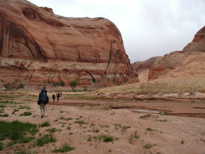 With the lake level down, the recently exposed sand and rock made for a pretty barren place, and as we rounded the first bend, I could see three Sears-quality nylon dome tents trying to withstand the assault of the wind and sand. I felt sorry for the occupants, and moved on quickly. I am not sure why I was in a hurry, since there were not many places to hide from the wind. Mother Nature would calm down when she felt good and ready. I waited for Susie and we hiked, squinting for a bit, looking for a spot to get out of the wind and adjust our gear. Within a few hundred meters, we came to a wall that afforded some protection, and I decided that a very abbreviated lunch was in order. I had deliberately porked out back in Hanksville, doubtful of our chances to get a formal lunch at the marina, but even eggs and hashbrowns and sausage can only take you so far. Most of the folks moved on while I prepared to make a pit stop, but before Susie took off, she and I had agreed that due to the density of the brush that we had heard about above the high water mark, we would stay in the stream bed, even if it meant hiking with wet feet. As I passed the first huge sand slide coming down from the south rim, I caught up to Susie in the creek bed. It was clear that at this point, one is faced with either thrashing through the willows and tamarisk that line the bench tops, or making faster but wetter headway in the creek bed. There was one other advantage in being down low: a bit more protection from the gusting wind. The disadvantage is that you can feel like you are hiking in a trough. Which, of course, you are. However, if you keep your eyes open, you will be able to spot Anasazi ruins high on the north wall. Will was so engaged in brush beating that I had to yell up to point out their position. Sue, on the other hand, was in ruin-deficit, having had to back out of the Grand Gulch trip last year due to family illness. She had no trouble spotting ruins. I think she could have found them on a cloudy night wearing a blindfold.
After about an hour and 20 minutes of walking, we found ourselves at our first beaver dam, about a mile and a third above our drop off point. While it was not more than 15 feet across, the water was a couple of feet deep, and it seemed an auspicious time to find our way up the bank and around the obstacle. In doing so, we spied an interestingly steep trail up a hill on the south side of the canyon leading to an alcove, and thought it would be a good time to check out the possibility of a ruin. A good example of how a sand scrubbed brain might not think too clearly. We made the steep climb, only to find nothing but sand in the alcove, and we chided ourselves for not having thought about the fact that an alcove facing NW is very unlikely to have been prime real estate for the Anasazi.
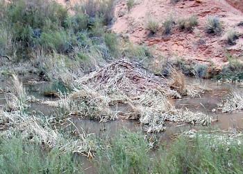
 A couple more bends in the canyon brought us to our next obstacle, a real Grand Coulee of beaver dams. I had never seen anything this large in canyon country before. This was one serious impoundment. Of course, not being blessed with web feet, the obvious approach was to find a way around the lake. The left side seemed best, and we skirted the "lake," about 15 feet above the water level. This worked for about a hundred and fifty meters or so, but we soon were cliffed out (no where to walk, short of exposing oneself to a high risk of falling into the water) so we had to turn back and find a higher route. About halfway back, I had recalled a cleft in the rock wall that might, with some scrambling, get us higher. I think after years of hiking in canyons, you get used to subconsciously logging alternative routes as you pass them, much like a burglar might subconsciously catalog houses with newspapers piled in the driveway: potentially easy pickin's. We started up the cleft, which required some scrambling and tripod passing, and got up about another 30 feet. I walked upstream a bit, but could see that we would be cliffed out again. So backtrack, and find a place where the walls are broken sufficiently to scramble higher. This process was repeated until we finally got to a broad bench. The broad bench did seem to move along well, the clouds returned, the wind picked up to the point that it was blowing sand all over everything, and I struggled to keep my large, keep-the-cancer-from-my-scalp Tilley hat from blowing off and down into Beaver Lake. Being a hundred feet or so above the water, we did get a nice view of the beaver lodge off to the side of the main channel. It seemed the size of a small human house, so this must have been a place where life was good, if you are a beaver.
The wind continued to gust, and I continued to cuss. Susie apparently had had enough of my sailor language (it is challenging to try to take photos with sand going in your eyes) and told me to shut up and accept the fact that the wilderness is going to throw me a few challenges. Point well taken, so I kept my head down, and held on to my hat. In a few minutes, Susie started yelling "Look, look, look!" I realized that I was about to step inside an Anasazi ruin. Admittedly, the walls had mostly fallen down, but it was a pretty good sized structure, that I had practically walked into without seeing it. I took a few requisite photos, cursing the wind, quietly. John showed up, and we walked together for a while, until we found a spring coming out of the north wall. It seemed like a great time to rest, and drink untreated water. Eventually, the streambed rises sufficiently that the beaver lake is no more, and it became within 30 easy feet of the bench on which we were hiking, so we dropped down to the stream bed. There was a nice spring coming in from a side canyon on the south, and John decided to stay and cool himself off for a bit, now that the wind had stopped. We thought we would push on, because I knew we were getting close to the spot at which I thought we might camp. Besides, it was nearly 5 pm, and it was time to quit for the day.
 It was not more than a couple more bends, and I heard George call to us. He had found a flat spot, and of course, there was water in the creek bed, and so even if there were only a few cottonwood trees, it looked like home. It was 5:15 when Susie and I pulled into camp, 4.5 hours to go 4.2 miles. People always ask me "How far do you plan to hike." If you tell them 4 -5 miles or so each day, they envision some easy stroll across the grass in a park. I have about decided to say "Well, we plan to hike for 4, 5 or 6 hours each day, moving as hard as we can, with maybe 65 pounds on my back." Let them ponder than for a bit. While Susie and I picked out a site in some shade, George reported that where he had erected his tent, it was 0.01 miles (53 feet) from the waypoint I had set for the first night's camp. "Yeah," I said, "even a blind hog finds a proverbial acorn every now and then." (Camp was 541351 Easting, 4146242 Northing. All the coordinates in this story are UTM on the NAD27 grid). But it did feel good that I had picked a reasonable spot looking at the topo maps and aerial photos. John pulled into camp a few minutes later, and Andy and Sue, who had spent some time in the ruins high up on the north wall not too long after we started hiking, were in about 5:45 pm. The rest of the crew showed up about 6:15, reporting that they had found about a "half mile back" an interesting "sentinel ruin" on a rock outcropping that was easy to climb up to. They just couldn't resist. I could see jealousy rising up in Sue's eyes, and I just knew where she would be headed first thing tomorrow morning.
It was nice to have water running right by our camp, even though we knew we had to treat it for drinking, due to all the cattle sign (read shit) and beaver sign (footprints, lodges, and cut down small trees). We gathered under some cottonwoods for dinner, (I claim that many of these trips with your close friends of 20 years or more feel like a seven day long dinner party with a bit of hiking thrown in) and reported on our various route finding adventures this first day. A&S indicated that instead of climbing up high to avoid Beaver Lake, they just tiptoed across the dam to the south side of the creek. To me, with my lack of balance, that had "swim" written all over it. We built a small fire to burn our plastic bags, and turned in early. The temperature was falling like a rock, and it was about 40 when Susie and I repaired to our tent. It was great to be back in Canyon Country.
© Roger A. Jenkins, 2002; Beaver dam photo © William H. Skelton, 2002; Captain Jack photo © Andrew P. Butler, 2002