
Moqui Canyon/North Gulch Loop - 2002
"Terra Incognita"
Pour-off city
Thursday, April 25
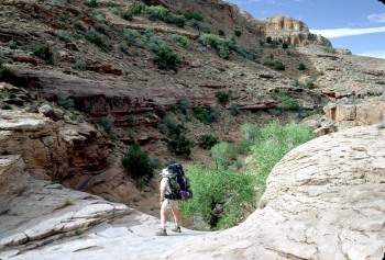 It was warm last night. Clouds moved in, and I don't think the temperature dropped below 60. Sorta slept in the general vicinity of my sleeping bag. We were up by 6:30, as we knew the tent would get oven-like if the coulds dissipated completely. I don't know what we did for so long, but it took us nearly 2.5 hours to get rolling. Perhaps we were enjoying having what we thought might be a couple of leisurely days ahead of us, and wanted to get into the spirit of it. The cloud cover held, and it was still a nice morning for hiking. The primrose were blooming, and we ran into a nice patch of them. It was not long before we ran into our first obstacle of the day, a large pouroff (at 547,502 Easting, 4152,931 Northing). There was an arrow drawn by Geroge in the sand pointing right (north side of the canyon), but it was not clear how that might work. However, it was obvious that with a bit of careful scrambling, we could make it around on the left side. As we were doing the scrambling, I could look up and see a large cairn erected on the other side of the canyon, way bigger than anything George would construct. I thought that there could be a significant possibility that we could get around this pouroff and get stuck at another one just down the creek. Walking downstream is always fraught with these sorts of challenges, since it is much harder to see what is ahead. Sure enough, in less than a hundred meters, there was another blocking pouroff. We had to go back or figure out a way around from this lower level. Our reconnaissance team, led by Ray and Andy, found that with some careful work up through some broken rock and around a point, we could climb back up to the level George had pointed us toward in the first place. Not that the scrambling was tough or dangerous, we just felt a little dumb having to do this. Primary rule of canyon hiking: believe your friend's directions.
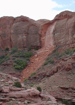 As we topped out, we could see that there was a pretty clear path. The bench walking was really easy, and it afforded views down canyon that we might not have otherwise had. Probably one of the most spectacular sights for me was a huge rockslide in a side canyon to the south with water coming out of it (mouth at 546,825; 4152,469). A chunk of vertical canyon wall, perhaps 150 feet high, by 100 feet wide and maybe 30 feet deep, had split off of the wall and crashed down below. This was a recent event, because there was nothing growing on the slide. My thought was: I would hate to have been standing on the canyon rim when it fell away like that. The devastation was enormous. Anyway, just downstream of this side canyon, we were able to return to the floor of NG, and it seemed to be time to split up again and do our own thing. We come together when needed, but I guess all of us like a bit of space. Susie and I decided to take a short break, but then pushed on.
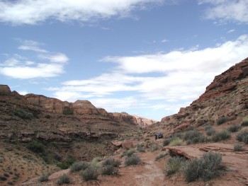
Truth be told, this stretch of the canyon was one of the nicest on the trip. Lots of slabs of slickrock in the creekbed, and the walls of NG seem to soar to the sky. National Park quality stuff. The next mile or so was spent craning our necks, and enjoying the scenery. The canyon was still pretty tight, but the walking was easy. Ahead, perhaps 250 meters, I could see Andy kneeling over, and I thought he must be photographing some flowers. He picked up and moved ahead a bit, and then Susie, who was about 100 meters ahead of me, stopped for a bit, and I could see that the "photographing" that I thought Andy had been doing was in fact, slithering along the ground, in an attempt to bypass another pouroff without falling into a big pool. I looked around, but crawling on ones hands and knees seemed to be the preferred route. You had to be careful, since if you arched your back too much, your pack would get caught on the overhanging rock. Since I had shorts on this day, my knees protested mightily. Andy and Sue seemed to be in a mood to celebrate having negotiated the route without falling into the pool, and they decided to explore a side canyon coming in from the south just downstream of the pouroff. I was starting to get a bit hungry, and thought that a better way of celebrating would be to find a nice pool, and eat. We moved downstream about a half mile, found a little spring flowing out of the south side of the canyon, and declared this to be lunch. John came by, filled his water bottle, and then pushed on. He was not out of sight more than a few minutes when he came back, and indicated that there was another big pouroff ahead. He said that there was a path on the south side of the canyon gently climbing a sand slope and that was the route he was going to try. Susie and I finished lunch, and decided that since we had not seen John return a second time, the south side would work.
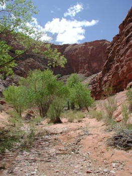
We began climbing the sandy bench and soon were about 60 feet or so above the level that the creek had been. We turned around, and could see the object of our bypass: the pouroff was indeed significant. About this time, Will and Diane showed up, and yelled across asking if the way we were headed looked clear. We could see that within a quarter mile, there was a sandslide dropping off a point, and by reversing direction, we could probably make it back to the canyon floor. I yelled back to Will that our way (the south side) seemed to work. He yelled back he was going to try the north side, because there were cairns and a path. Just like Will, always wanting a slightly different adventure. Susie and I had to climb only a bit higher to begin dropping toward a spine of the bench on which we were walking. Our route did go, and before long we were on the bottom. Definitely looked like permanent water from here down. When we were up on the bench, as far down canyon as we could see, there was green vegetation in the streambed. If the water continued flowing (it did), it would mean that there is, at this time of year, permanent water higher up in the canyon than Kelsey indicates on his maps. Ok, so now we were on the bottom, following cow paths through the trees and bushes. Will was on a bench about 50 - 75 feet above us, reporting that it was very smooth walking up there, but it was not clear how to get down. We yelled back up to him that there was no where we could see that a descent off the bench was possible. Susie and I worked our way through tiny forests of even aged cottonwood trees, speculating that beaver must have clearcut the area in one season and then moved away.
 Susie indicated that it was time for her to make a long duration pit stop, and I told her that I had been wanting to stop too, but there had not been many good places sufficiently far away from the creek bed. As I was finishing up, burning my toilet paper [yes, we do burn it, but very very carefully, especially after seeing the impact of toilet paper fires in Deer Creek in the Grand Canyon and Grand Gulch, I looked up across the canyon, and there is Will with his zoom lens out, completing his photographing of my taking a dump. Some folks really get off on the strangest things. I commented to Susie that Will must be collecting photos for a new Usenet Newsgroup: alt.binaries.photos.peopletakingdumps. We both laughed, shook our heads, and went back to pushing through the greenery. Before long, we had to leave the floor and climb up on a low bench on the north side. But we soon came up on the large side canyon coming in from the north, and could hear Will yelling for us. He was in the shade, just opposite the mouth of the side canyon high up on a bench, along with John. He had walked nearly 1.3 miles on the bench, and indicated that there was no easy way to get down until the path comes to the mouth of the canyon that we were looking at. (However, George indicated later that he had found a way down before he had arrived at the side canyon mouth.) He was also complaining that George had apparently moved on, and that he could not understand why he had not stopped here and found a site. There was obviously good water, potential exploration, and that there must be some campsites up in the side canyon. I pointed out that George may have, in fact, checked out the side canyon and found nothing. I also pointed out that the plan was to get to within a mile or so of a spot we had marked on the map, and that if Will wanted to be the one to pick out the campsites, then he just needed to get up and get going before George did, and move faster than George. Since Will likes to sleep late, and take long breaks, neither of those requirements were particularly appealing. All he could do was grouse. I tried to reassure Will that George would find us the best place he could, and I was sure that if he found a decent spot in the next mile or so, he would stop.
Susie and I decided to move on, having just had a nice break, albeit one in which we were photographed. We noted that there was a lot of water coming out of the side canyon, perhaps doubling the flow in North Gulch. That was reassuring. It was hardly more than a third of a mile when we heard George calling to us. He could hear us thrashing through some dense vegetation, and wanted to make sure we did not miss the campsite. He had found a pretty good, albeit small spot on the south side of the creek. It had a nice cottonwood, but even better, it had hard shade. Hard shade, caused by the canyon wall screening the sun, is the best of all. 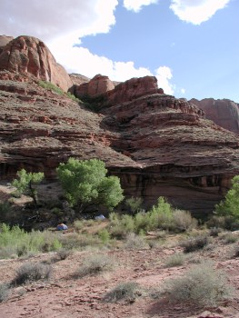 Even though one had to be careful choosing one's tent site, and then there was a bit of micro-topographical adjustment required, it looked like home to us, for sure. We arrived about 2:10 pm, or our usual 5.3 hours to cover a little over 4 miles. If you like to cover large distances when you hike, this is probably not a good place to be. However, with the temperatures in the sun pushing well over 100, hiking into the heat of the afternoon just doesn't feel like a lot of fun. We set up our tent in the hard shade, hoping it would only expand as the afternoon wore on (it did), went down canyon a bit to take a bath in the sun, and then set to relaxing. Susie went in the tent to get away from the flies. They had replaced the noseeums as our resident winged pests. When Diane and Will got into camp, they reported seeing the cow/steer that had made all the recent footprints we had seen, and the fresh cowshit that infested the area. Will says, and since he grew up on a farm, I gotta believe him: The more cows, the more bugs. This canyon complex is clearly one that needs to be freed from the cattle grazing. The cattle do so much damage, and frankly, with beef consumption dropping in this country, the idea of the government continuing to subsidize the production of "free-range" beef is a bit disconcerting.
After a dinner of our homemade Santa Fe Chicken, we built a tiny trash fire to burn our non-aluminum foil trash right on the edge of the creek. The next rain storm would carry the ashes away. We watched the near full moon rise over the canyon rim. Andy claimed that it was not truly a full moon, since it had risen 40 minutes before the sun set. But it seemed pretty darn full to me. It was a neat sight, and if you did not get enough the first time it rose over the rim, you could walk a few feet forward and watch the whole thing all over again. Simple pleasures are often the best. It was a bit cooler than the previous night when we went to bed, since it was clear. Better sleeping weather.
© Roger A. Jenkins, Suzanne A. McDonald, 2002