
Moqui Canyon/North Gulch Loop - 2002
"Terra Incognita"
Layover
Tuesday, April 23
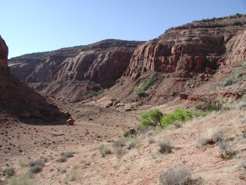 We crawled out of the tent as soon as the sun hit us: it would be a warm day. Fortunately, the noseeums were still asleep, but we knew that would not last long. As usual, multiple people, multiple plans. Our campsite sat at the junction of two major canyons. Moqui Canyon heads to the east for more than a dozen miles, and the side canyon that comes in just opposite of the canyon that holds Harrison Spring - so we were calling it Harrison South, goes on for at least 8 more miles. Plenty to keep you occupied for a day. Some folks were headed up Moqui, others up Harrison South. George wanted to take it easy, knowing that tomorrow might end up being a very long day, if it was anything like the last time we crossed a mesa on April 24th. Susie and I and Sue and Andy decided that Harrison South seemed a bit tighter, and also had several springs advertised in its lower section. Heading that direction would also permit us to check out the spring that Ray had discovered.
Since Ray's spring was closest, that was the first objective. The spring proved easy to get to: a gentle climb up the side of the canyon just south of camp. It is in an area of burned trees, about 75 feet off the canyon floor, at 551125 Easting, 4150443 Northing. It was a real gusher, coming down the hillside. A refreshing site in such a parched landscape. And much better and flowing harder than Harrison Spring. However, who knows what it might be like in September. George reported that he had hiked a bit down Harrison South, and only found a patch of wet sand on the canyon floor. And that is true. Despite the fact that the spring is running really well, it disappears into the earth before it reaches the canyon floor. However, 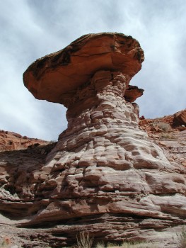 there are several more springs that add to the water supply, just a bit up canyon. One we found coming out of a miniature forest of small oak trees. It was interesting to see these, since most of the trees we had seen were cottonwoods. We took several photos, since this little forest all looked like even aged timber, even though we don't suspect a history of clear cutting in this area. The map shows several springs up this canyon, in many cases, higher up on the canyon wall or in side canyons. We found a couple close to the canyon floor, at 552059,4149988 and 551800,4150078. At one point, there was a spot where the water was actually bubbling out of a hole in the stream bed. Pretty nice.
The floor of Harrison South varies from loose sand to hard slick rock. The latter was obviously nicer to walk on. There was enough variety to keep us interested. We found several abandoned drill holes in the stream bed, probably from the uranium mining exploration in the 50's. Susie and I stopped in a large jumble of rocks that had formed chokestones, having slid off the south wall of the canyon. The shade proved an excellent spot for a break, although again, it was a bit cool. There was an interesting mushroom rock nearby, with the capstone being much larger than the supporting member. It only took a bit of scrambling to get through the chokestones. Then we were out in the open. We hiked on for another half mile or so, but decided to turn around, as it seemed that the canyon was going to look about the same for a while. Of course, such is never the case. Sue and Andy went perhaps another mile and a half more up the canyon, and found large pools of water in the stream bed. So it seems that one could probably make this a traveling canyon: It may be possible to come in on one of the sandslides in the lower part of Moqui, hike up to Harrison South, go up to its head, cross over into Moqui, and return all the way back down Moqui to the sandslide. As Susie and I got back to the area of the chokestones, she spotted a small track skirting the north side of the stream bed. It climbed up on the bench, and was an obvious bypass of the chokestones. 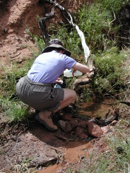 Probably left over from the mining days. It was easy to see heading down canyon, but tough if you are moving up canyon.
We had taken our waterbag with us, so we could fill it and water bottles when we passed by Ray's Spring on the way back. We had run into Diane and Will coming up canyon, and Will had indicated that he had "re-engineered" the spring, to make it much easier to bathe and wash clothes. I could not imagine an improvement over what had been there originally. When we got there, Will had dug out and dammed a pool right at the spot where we had gotten water previously, making it much harder to get to the water flowing into it. In addition, the engineered upper pool he had made, that he claimed was "perfect for getting water out of" had been constructed with mud, rocks, and sticks. Of course, the mud was already being eaten away and clouding the water that was headed for the lower pool. This necessitated us climbing up another 30 feet or so to the "drinking water pool" to get silt-free water. Hopefully, by the time anyone else gets there, all this construction will have been washed away. As an engineer, Will makes a great attorney.
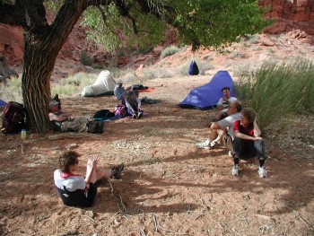
Back in camp, we debated where to go to bathe, another indicator of the weighty discussions we were having. Andy and Sue had found a small private pool in a side canyon that they were keeping to themselves, Barbara reported that she had found a cow tank with lots of water flowing out of a pipe about 20 minutes up Moqui, George would take Harrison Spring, and since Will and Diane were going to use the "engineered pool," Susie and I opted to head back down canyon. I guess this number of choices suggests that the canyon was not as dry as it might first seem. Dinner was a relaxed affair, where we went through the nightly routine of beating off the noseeums and burning our trash in a small fire. The real entertainment of the evening was watching Ray try to roast a marshmallow over the fire. Clearly this was something at which he seemed to have only limited practice.
© Roger A. Jenkins, 2002