
Moqui Canyon/North Gulch Loop - 2002
"Terra Incognita"
Crossing the mesa
Wednesday, April 24
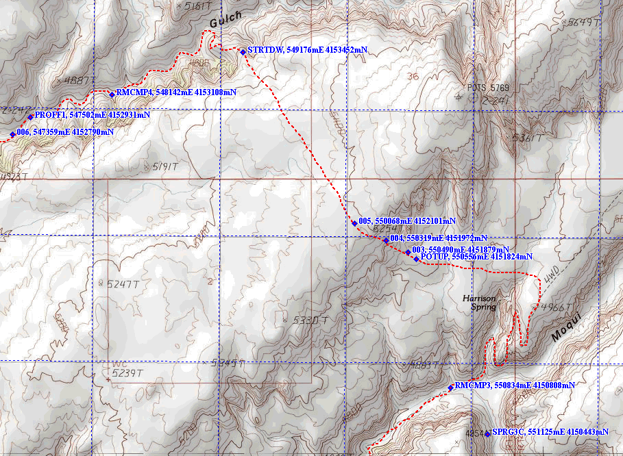
 Today, we all knew, would be "the crux" of the trip. Overall, the idea was to climb out of Moqui Canyon on this old uranium mining road, using it to get to the first major bench on the mesa, about 500 feet above the level at which we had been camped. We would then leave the road, heading NW, and try to find a way to climb up on top of the arm of Mancos Mesa the separates Moqui from North Gulch. That would involve another 400 feet of climbing. Crossing the arm of the Mesa, we would descend into North Gulch, and try to find water and a campsite. There would be at least two challenges. The first was finding a way up on to the mesa top. I had plotted a long route that took us way to the west, in an attempt to find a "gentle" route. However, this involved several miles of walking west, and then traversing the mesa in a NE direction, to get to the second challenge: the way into North Gulch. The walls of North Gulch in the area that I felt offered the best way down were about 400 feet high. There were lots and lots of overhung alcoves visible on both the aerial photos and the topo maps. While there is always some way to the bottom, the trick is to find it. I thought I had found a potential spot that looked sufficiently gentle for us to make the descent. I had even modeled the terrain using 10 meter resolution digital elevation models. But all it takes is 10 or 12 feet of sheer wall in the wrong place, and you are stuck. I guess that a third challenge could have been water. If one studies the maps of North Gulch, you can see that a) the floor of the canyon is at an elevation several hundred feet higher than that of Moqui directly to the south, suggesting that the geologic strata could be different and b) there are far fewer springs on the topo map, suggesting that it is a dryer place. Our plan, assuming we could get to the floor of North Gulch but not be able to find any water, would be to go up into Secret Spring canyon and keep looking until we got to the spring. Since the spring was 2 miles back into the canyon, and the gentle route across the mesa went for several miles, we could be in for a long hot day.
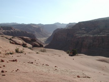
 The route that the 4WD "road" takes out of the canyon is interesting. It curls around in Harrison Spring canyon and climbs between two huge rock walls that are part of a giant cleft in the canyon wall. Very spectacular. But it is heavily eroded and very steep. I would think it is way too steep and rocky for the ATVs that Ray refers to as cockroaches. We took photos of each other coming up through the walls, and then eventually topped out on the first mesa bench. It had taken a little less than an hour to go 1.3 miles. The view up Moqui was really super from this point, although we were disappointed that it was hazy. One could see Navajo Mountain, but not really well. We waited for Diane and Will, and plotted our strategy. The route I had picked out initially would be easy, but it was long. My preference was a more direct route to the top of the Mesa, but I was a realist, and knew that what might look simple on a map might be tougher on the ground. The alternative that was much shorter and probably do-able, and we spent some time searching for it while we waited. There were two white spots of slickrock on the mesa wall, near a break in the wall that I had labeled POTUP (for Potential Up; I get much grief for my GPS waypoint naming). From where we stood 3/4 miles away, it looked like a possibility.
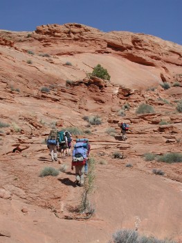
When the two of them arrived, Diane indicated that she didn't need a rest break, so we all took off. We left the old track near 551,549 Easting, 4151554 Northing, and headed around the head of the canyon that holds Harrison Spring. The terrain was undulating, and I admit to a bit of disappointment that it was loose sand, not solid slickrock. On the other hand, I could see that we were less than a mile from starting the next climb, and if it worked, we could avoid a couple more miles of loose sand. We wound around, generally keeping to our planned route, and with a few big steps, we finally hopped up on the slickrock, near the place that looked potentially doable. We noted that Will and Diane seemed to have disappeared again, and while we waited, several of us independently reconnoitered the proposed shortcut. We all came to the conclusion that with a bit of finesse, it might just go. When the two remaining folks showed up, Will admitted that after we all started hiking again, the two of them decided that they really did need a break and so had taken one. This crew is a bunch of pretty independent operators, and I think it is really hard for us to clump up in a group, even when the terrain necessitates it. Some folks have a harder time than others.
 The rest of us were pretty well rested for the final climb. We picked our way up a couple of easy seams and broken slickrock It turns out that one of the white patches we had seen from the road was in fact the way to go (near 550,556 Easting, 4151824 Northing), and with a bit of scrambling, tripod and walking stick passing, and big steps, bang, we were on top. Damn, it felt good. Everyone seemed to be pleased that we were so close to the shortcut route, and after a brief break to snack and record GPS waypoints, we took a compass bearing for the key waypoint, STRTDW, which I was chided about unmercifully, as being pronounced "start dawah." Why would you ever name a waypoint that?? (Click here for a 383 KB map of the traverse route taken.) Anyway, the Mesa slopes away to the north, and thus makes it really hard to see nearby terrain at a lower elevation. The point at which I expected we would really begin the descent (start down) was at 549,176 easting, 4153452 Northing, about a mile away. With the Henry Mountains in the background, the easiest thing to do was to set a bearing for the southernmost peak, and as Steven Tyler might say, "Walk This Way." It was pretty straightforward, as the mesa sloped toward the canyon, until you got close to the key feature on which we would do our descent. We had to adjust our course a bit, taking a line of shallowest descent. We all noticed a huge cairn sitting out right near where we intended to begin our descent. Such seemed to please Will: not only were we taking a route that looked like it might work, but were on the same route that someone else had taken. I guess I was not too surprised: after studying the maps and photos for so long, this seemed to be nearly the ONLY route that made any sense. Unless you can fly.
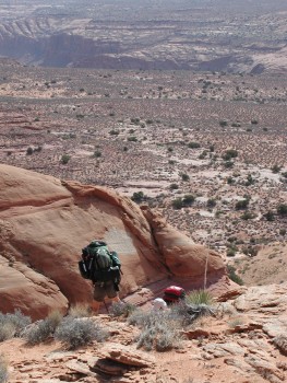
As we headed for the descent spot, picked out from looking at a photo, it was interesting to me how the terrain looks so much different when you are at ground level. Another reason why I have become a huge fan of using a GPS when you are in tricky situations. We quickly got to a small slot through we would have to descend. A bush growing in the way made us work a little harder, but it was perhaps only 12 feet, and eminently doable. Besides, there seemed to be no other way. After dropping through it, lunch seemed to be in order. While we still were not certain we could make it all the way down, things were looking promising. After lunch, it was pretty much a zig zag to the last pitch. No obvious route, just 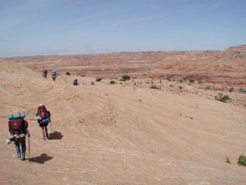 find the easiest way down. We got to a spot about 20 feet from the bottom, and it seemed to be time to take off our packs and hand them down. This is always a slow process, and while several of us were waiting to stage people on various ledges, Will found a walkable route down, which he, Diane and Barbara used. Ray found another route, but it brought him down to the canyon floor just upstream of a small pouroff that appeared to block his way. He did find a way around and came over to help us with packs. He was probably sorry he did such, as he nearly fell over backwards when he picked up mine. After getting the packs out of the way, it was a quick scramble to the bottom, and we were all feeling pretty good: we had carried the 50 feet of gold line rope with us again this year without having to really use it. So far. (Note that 50 meters upstream of this point, there was a major pour off that would block the route. It looked like it would take some doing to get around it. Something to keep in mind if you choose another route higher up in the canyon.)
In a matter of minutes, we started moving through the chokestones just downstream of the pouroff. I recalled that in my looking at the aerial photos, North Gulch seemed much tighter than Moqui, and lost elevation more quickly. If these chokestones became the rule for this canyon, it could be a very long way out. Sue and Susie seemed to be out in front, and I heard a big whoop from Susie. She cried "Water!!" Talk about the elixir of life. I had really been concerned that it would be difficult to find water in the upper part of this canyon. North Gulch is much straighter than Moqui, and usually the less twisty the canyon, the less water in it. Compare something like Grand Gulch
with North Gulch on a map.)If we had water already, albeit in a deep pool right under a choke stone, then all we needed was a flat place to camp, and we would be home free. But it was hot in the sun, for sure. The choke stones cleared up and we moved down to the point 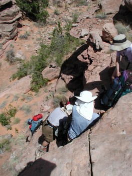 where Secret Spring Canyon comes into North Gulch. It seemed like a good spot to take a break, since it had been an hour since we finished lunch. I was munching on some M&Ms when Sue showed up (I had not realized she was gone.) She reported that she had a fantasy last night. (And I am thinking, boy, this is going to be good!) that when we got down to the bottom of the canyon, there would be big pools of water, and trees and shade and a flat place to camp. Well, she said, there is a nice stretch of water, about 30 meters long, a couple of trees and a small amount of shade, and a big flat place to set up our tents. "We're home!" I asked, "Since this is a fantasy, you are probably going to tell us that it is only about 6 miles down the creek bed?" No, she said, just around the corner. So we hoisted quickly and true enough, the campsite was just around the bend, no more than a couple of hundred meters away. Life was very good.
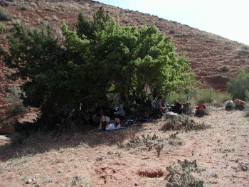
Ok, so it was not perfect. Shade was very limited. We all sat our packs down in this little tiny grove of oaks, and clustered around in the shade. It was 80 in the shade, which meant it was easily 100 in the sun. And when you walked out on the dry bench that had been baking in the sun all day, it felt, well, like an oven. Clearly, the most prudent thing to do was to sit down in the shade, drink water, and replenish vital calories that had been burned during all this tough activity. Most of us just sat around in the shade, discussing what the next most important thing to do was. Bathing seemed to be high on many peoples' minds. In the heat the prospect of cool water on one's naked body sounded like a great idea. One tiny issue: with a strip of water barely 75 feet long, and no "vegetative screening," privacy was non-existent. Leave it to George to figure it all out. He announced that bathing should be done in half hour increments (including laundry and getting of water). While there is bathing going on, everyone in camp, which overlooked the obvious bathing spot, had to face away from the stream. So we all signed up for our bathing time, although I am not sure Ray gave two hoots. His concept of bathing is something like running a wet bandana over his body. Environmentally conscious, I guess. Anyway, Susie and I opted for the first slot, beginning at 3 pm. Andy and Sue got the next slot, then the guys had to bathe together, etc. Due to the temperature, no one seemed very interested in erecting their tent out on the bench. I recalled once setting up my tent in the mouth of Buckskin Gulch (Lower Paria Canyon). I left the fly off of it during the day, since I knew it would not be raining. I left a water bottle in the tent, as well as my personal kit. The tent was only in the sun 4 hours max (very steep walled canyon at this point), but the temperature of the water in the bottle in the tent was 120 and, as I found out later that evening, my solid deodorant had melted into my toothbrush. Yuck!
 Dinner was a low key affair, (pesto pasta, freeze dried chicken and dried mushrooms, with lots of grated Romano cheese ) held down at the creek bed, as the air was a little cooler there, and since the sun still had not dropped behind the canyon wall, the lone bunch of oaks provided some relief. We chatted for a while after dinner, confirming the change in plans that we had tentatively agreed to the previous day. Originally, our plans had called for a layover day after we had dropped into North Gulch. However, as we had gained experience with Moqui, and began to mentally confront potential challenges in North Gulch, we had decided that we would divide up the remaining distance in NG into two easier days, unless the campsite we now occupied had turned out to be a real Shangri-La. (It wasn't.) Our reasoning was that breaking up the remaining distance would put us within a mile or two of the exit on Friday nite, and this would mean, keeping with the relaxed pace of the trip, that we would not have to get up super early to get to the pick up point in time for Captain Jack (you can call me by my first name, ‘Captain') on Saturday morning. It would give us lots of time for exploring side canyons, and who really knew what challenges we would encounter in the next couple of days? Indeed.
© Roger A. Jenkins, 2002