
McCloyd, Owl and Fish Canyons 2009
Déjà vu all over again
Trying to find a way
Sunday, April 26 We awoke to a cold, clear morning, welcome after the awful dust and high winds of yesterday. The motel continental breakfast could have used some beefing up, but it is a long way out here. (Thankfully, Will and Kim had saved their leftover pizza from last night and everyone - except Susie and I - had a half a piece or so). We were completely ready to roll at 8:30 am, which we did. First stop was the Kane Gulch Ranger Station. Volunteer rangers, or information personnel, staff this place, and boy, what a change from the '90's when the station was an old house trailer, or the '80's, where there was nothing. The rangers (for want of a better word) were ready for us. They had our prepaid reserved permit ready to go. But they also had some advice. They strongly recommended we reconsider the idea of going down McCloyd and trying to use the bypass route around the pouroffs. They pointed out that one person had died last year in the area downstream of the pouroffs (note: I have yet to be able to find any reports on such on the Internet). (Note: The BLM is referring to the canyon as "McLoyd" It is unnamed on the USGS Quads.)
I asked one of the volunteers if we could get into lower McCloyd via Kelsey's route into the South Fork, and he indicated we could. However, Sue remembered later that he admitted he had never been in or out via that route. So we left the new ranger station (complete with permanent pit toilets: pretty upscale) with a realization that we would have our work cut out for us. There was a lot of talk among the group about scouting the pouroff bypasses this afternoon, just to see how tough they were. But of course, we had to get to the trailhead to start hiking.
After we missed the turn once (I was in the lead but had my package of my "approach maps" in Sue and Andy's vehicle), we finally made the correct turn into the Owl Creek trailhead. It is maybe a 15 minute drive out there. The road is pretty good, except for one place where it crosses a wash, and has a significant dip in it. Boy, the trailhead itself was plenty busy with only a few spots left for parking vehicles. They have put in a pit toilet now. Obviously, a lot of use. In the paved parking lot of the ranger station, we had moved all the group luggage into our Highlander, since it would be the shuttle vehicle, and all the packs into the Expedition of the Knox5 and A&S's Jeep Commander. We headed off to the turn on to Snow Flat road, a few miles south on Hwy 261.
 I had heard lots of bad things about the
Snow Flat Road. Will and Carol, after last year's trip, had attempted
to drive it in Carol's old van but turned around after three miles. So
it would be interesting to see if it lived up to its reputation. We
took it slow and easy going out. The first couple of miles are not
bad, but then it gets to the point where you have to watch closely to
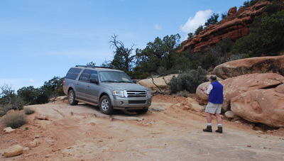
avoid rocks, etc, sticking out of the road. At about 3 miles, we got
out of the vehicles to direct them down over a slickrock shelf. In
all, it took us about 50 minutes or so to do the 8 miles out to the
drill hole which is a good place to park. There is a spur road that
goes out to the lip of the canyon from the drill hole area, but we
were not sure if it was driveable, so we figured we had pushed our
luck far enough. Since we had a relatively short hiking distance this
day, why make it hard? By the time we got our packs on and gear
adjusted, it was noon. 3.5 hours to get from Blanding, stop at the
ranger station, run a short shuttle, get to the trailhead and saddle
up. I had figured it would take us 3 hours 10 minutes, and a certain
attorney on the trip might have poo-pooed such, but it turns out, I
was overly optimistic.
I had heard lots of bad things about the
Snow Flat Road. Will and Carol, after last year's trip, had attempted
to drive it in Carol's old van but turned around after three miles. So
it would be interesting to see if it lived up to its reputation. We
took it slow and easy going out. The first couple of miles are not
bad, but then it gets to the point where you have to watch closely to
avoid rocks, etc, sticking out of the road. At about 3 miles, we got
out of the vehicles to direct them down over a slickrock shelf. In
all, it took us about 50 minutes or so to do the 8 miles out to the
drill hole which is a good place to park. There is a spur road that
goes out to the lip of the canyon from the drill hole area, but we
were not sure if it was driveable, so we figured we had pushed our
luck far enough. Since we had a relatively short hiking distance this
day, why make it hard? By the time we got our packs on and gear
adjusted, it was noon. 3.5 hours to get from Blanding, stop at the
ranger station, run a short shuttle, get to the trailhead and saddle
up. I had figured it would take us 3 hours 10 minutes, and a certain
attorney on the trip might have poo-pooed such, but it turns out, I
was overly optimistic.
 The hike on the packed sand and dirt was
easy, and we only found one tricky spot that might stop vehicles.
Indeed, when we got to the car park near the canyon lip, there were
two vehicles there. We waited briefly for Kim and Will, and then began
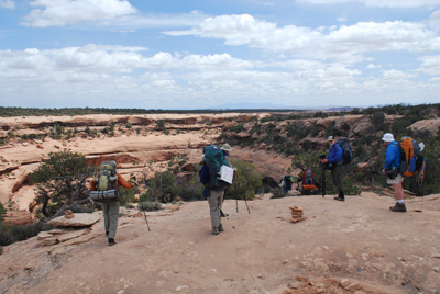
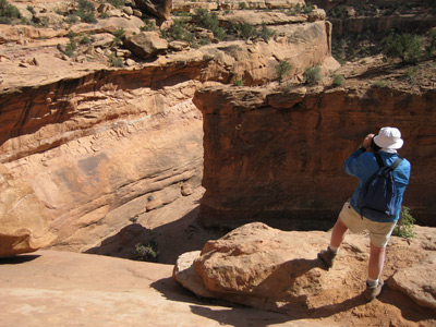
the descent, a bit after 12:30. The route is very obvious. It goes
left and is very well marked and then cuts right to cross some sloped
slickrock. We could see day hikers on the other side of the canyon,
inspecting the ruins. A popular spot. Anyway, when we got to the
slickrock spot, the best route is not necessarily obvious. I remember
when Susie saw it, she said: "Oh no, that can't be the spot." I
confess that it does look tricky, especially when you are descending
with a full pack on. (Note: With the current Cedar Mesa Plan, 2009 will be
the last year that backpacking will be permitted into McCloyd Canyon.
More about this later.)
The hike on the packed sand and dirt was
easy, and we only found one tricky spot that might stop vehicles.
Indeed, when we got to the car park near the canyon lip, there were
two vehicles there. We waited briefly for Kim and Will, and then began
the descent, a bit after 12:30. The route is very obvious. It goes
left and is very well marked and then cuts right to cross some sloped
slickrock. We could see day hikers on the other side of the canyon,
inspecting the ruins. A popular spot. Anyway, when we got to the
slickrock spot, the best route is not necessarily obvious. I remember
when Susie saw it, she said: "Oh no, that can't be the spot." I
confess that it does look tricky, especially when you are descending
with a full pack on. (Note: With the current Cedar Mesa Plan, 2009 will be
the last year that backpacking will be permitted into McCloyd Canyon.
More about this later.)
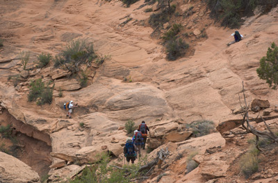 Sue was the first one down to
the slickrock and she did not like the looks of it, so she decided to
go higher. I saw a seam, much more conveniently located, and walked
across it to the spot where we would have to lower packs. By this
time, Sue had realized that to get to where I was, she would have to
butt-slide the slickrock, because it was steeper than she wanted to
walk. She had started doing that, but everyone encouraged her just to
get up, walk back to the starting point, and walk the seam that I had
used. While, for us, the difficulty with doing this was merely because
we had full (including 6 nights worth of food with us) backpacks. With
day packs, we likely would not have given it a second thought.
However, by the time I had removed my pack, and had started uncoiling
the rope to lower packs, a large group of day hikers appeared (they
were from Colorado, on some sort of guided trip). It was clear that
many of them were very uneasy crossing the steep slickrock, and some
had to be roped up while the descended off the pack-lowering-required
shelf.
Sue was the first one down to
the slickrock and she did not like the looks of it, so she decided to
go higher. I saw a seam, much more conveniently located, and walked
across it to the spot where we would have to lower packs. By this
time, Sue had realized that to get to where I was, she would have to
butt-slide the slickrock, because it was steeper than she wanted to
walk. She had started doing that, but everyone encouraged her just to
get up, walk back to the starting point, and walk the seam that I had
used. While, for us, the difficulty with doing this was merely because
we had full (including 6 nights worth of food with us) backpacks. With
day packs, we likely would not have given it a second thought.
However, by the time I had removed my pack, and had started uncoiling
the rope to lower packs, a large group of day hikers appeared (they
were from Colorado, on some sort of guided trip). It was clear that
many of them were very uneasy crossing the steep slickrock, and some
had to be roped up while the descended off the pack-lowering-required
shelf.
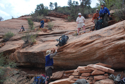 The shelf in question has a pile
of rocks under it, making the step off of it possible. But the rocks
are shaky, so some care is required. Anyway, I lowered the packs to
John. He unclipped them and figured out where to place them out of the
way. (Note: 10 packs and 9 people is a real squeeze in the tiny
platform area.) We got all packs and people down, loaded up, and
walked the next shelf in the upstream direction, looking for a place
to sit down and eat lunch - a late lunch. It took the day hikers quite
a bit of time to negotiate the aforementioned shelf, and we had just
about finished lunch when they passed us. I was behind some of them as
we descended a rubble pile to the floor of the canyon, and they were
moving more slowly than I was. I could tell that many of them were not
used to canyon hiking.
The shelf in question has a pile
of rocks under it, making the step off of it possible. But the rocks
are shaky, so some care is required. Anyway, I lowered the packs to
John. He unclipped them and figured out where to place them out of the
way. (Note: 10 packs and 9 people is a real squeeze in the tiny
platform area.) We got all packs and people down, loaded up, and
walked the next shelf in the upstream direction, looking for a place
to sit down and eat lunch - a late lunch. It took the day hikers quite
a bit of time to negotiate the aforementioned shelf, and we had just
about finished lunch when they passed us. I was behind some of them as
we descended a rubble pile to the floor of the canyon, and they were
moving more slowly than I was. I could tell that many of them were not
used to canyon hiking.
We got to the floor of the canyon, and I made the mistake of attempting to go through a rock jumble to get past a shelf and down on the real streambed. Big mistake: what a mess. Since I had gone down with my pack on, I needed help from Andy: I had to take my pack off and try to lift it back up to him, all while leaning at a sharp angle to the side, and then slither back up through the rocks. Meanwhile, the rest of the crew had found the "recommended route" which stays higher on a rock shelf and involves some big steps down, about 50 meters beyond where I tried. Finally to the real floor of the canyon, the hiking was easy, and we moved downstream, searching for a campsite large enough to accommodate 7 tents (3 couples and 4 singles). I had originally suggested a site that was about a half mile downstream of the ruins, in a little side canyon, based on looking at satellite photography (lots of trees). But it was jumble of rocks, so we kept on. Another couple of hundred meters downstream, John found a site that looked like it would work (near 12S, 607228 E, 4143200 N), assuming we did not mind being close to each other. (Note: all the coordinates mentioned in this write up are on the UTM NAD27 grid, so as to be compatible with paper topographical maps.)
 I think we all got our tents set
up, and then headed down canyon to "scout" the pouroff bypasses, or at
least look at the pouroffs. The first one encountered is about 2/3 of
a mile downstream from where we camped (near 608177 E, 4143052 N. It
is not high, perhaps 30 - 40 feet or so. But the walls were sheer on
both sides, for as far as we could see. We saw Sue and Andy out in
front of us on canyon left (the side opposite the side one would need
to be to actually bypass the pouroffs), spending some time working
their way around a boulder near the canyon rim. Susie and I elected to
stay on the left side, to afford better views. We walked along a
slickrock bench for a couple hundred meters, and the canyon bottom and
terrain became increasingly intimidating. It appeared that there was a
second pouroff, just downstream from the first, such that by the time
you got out a bit further on the shelf, the canyon bottom looked much
further down. We got to the rock that A&S had spent time
negotiating, and Susie was really uncomfortable with going any
further. The routes forces one out near the lip of the canyon, and
made me feel uncomfortable as well. Besides, A&S were already out
as far as one could go, taking photos of the bypasses, at least from
their vantage point. They would ultimately find both the "crawl route"
(one has to crawl under an overhanging ledge, dragging one's pack
behind oneself) and the "ladder" which is really an old tree braced on
top of a rubble pile that can be used to get off the aforementioned
shelf and down a bit lower.
I think we all got our tents set
up, and then headed down canyon to "scout" the pouroff bypasses, or at
least look at the pouroffs. The first one encountered is about 2/3 of
a mile downstream from where we camped (near 608177 E, 4143052 N. It
is not high, perhaps 30 - 40 feet or so. But the walls were sheer on
both sides, for as far as we could see. We saw Sue and Andy out in
front of us on canyon left (the side opposite the side one would need
to be to actually bypass the pouroffs), spending some time working
their way around a boulder near the canyon rim. Susie and I elected to
stay on the left side, to afford better views. We walked along a
slickrock bench for a couple hundred meters, and the canyon bottom and
terrain became increasingly intimidating. It appeared that there was a
second pouroff, just downstream from the first, such that by the time
you got out a bit further on the shelf, the canyon bottom looked much
further down. We got to the rock that A&S had spent time
negotiating, and Susie was really uncomfortable with going any
further. The routes forces one out near the lip of the canyon, and
made me feel uncomfortable as well. Besides, A&S were already out
as far as one could go, taking photos of the bypasses, at least from
their vantage point. They would ultimately find both the "crawl route"
(one has to crawl under an overhanging ledge, dragging one's pack
behind oneself) and the "ladder" which is really an old tree braced on
top of a rubble pile that can be used to get off the aforementioned
shelf and down a bit lower.
Most other folks scouted the route as well, Terri and Barbara, and Will and Kim scouting the right side of the canyon going downstream. ( As least as far as they could go, which was only part of the 3/4 mile from where you have to climb up to begin the pouroff bypasses to the point where you can come down to the floor of the South Fork of McCloyd. Because it is around another canyon bend, it is impossible to see the final blocking pouroff, which is about ¼ mile upstream of the mouth of the South Fork.)
Susie and I hiked back to a good bathing spot and cleaned up on some nice rocks, but we had a pretty good idea of what the scouts would report: there was no way that anyone who had seen at least part of the route was willing to risk taking the bypass. I was OK with that. I think I had suspected that the ranger from whom I had received the original information may not have been well informed about the likelihood of successfully and safely doing the bypass with backpacks. Fortunately, I had a Plan B and Plan C in mind.
Dinner was a crowded affair at this campsite: Susie and I could face other diners as long as we un-staked the vestibule pull out of our tent fly. This was just not a big campsite. But everyone seemed to be happy now that we were underway. Susie and I had Cajun rice and beans with dried ham this evening, which was better than usual. Maybe it was because the ham was actually chewable. Over dinner, we decided on our Plan B: we would spend a layover day tomorrow as planned in the bottom of McCloyd Canyon, spending time looking at Moonhouse and other ruins. The following day, Tuesday, we would climb out of McCloyd the way we had come in, go cross country over to the spot on the rim of the so-called South Fork of McCloyd, and descend and see if we could get all the way into lower McCloyd below any blocking pouroffs. Most of us were in bed by 8:30 or 9 pm. Lots of us suffering from a bit of jet lag.
To view supplemental photos of this trip, go to our TwoHikers SmugMug gallery.
To view additional and different photos of the trip, go to Andy's and Will's Internet photo galleries.
© Roger A. Jenkins, Suzanne A. McDonald, 2009, 2016; Photo of people on slickrock shelf © Andrew P. Butler, 2009