
McCloyd, Owl and Fish Canyons 2009
Déjà vu all over again
Plan B doesn't work either…
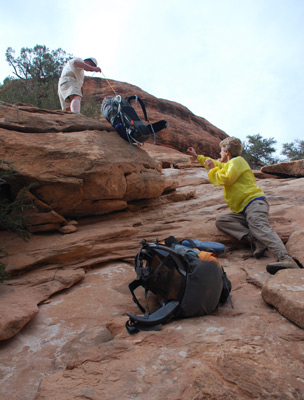
Tuesday, April 28 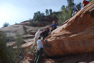 Despite the cool morning, we were up and at 'em first
thing. We planned to leave camp by 9 am, but most folks were out
early. Susie and I left at 8:49 am. Plan B was as mentioned above, so
the first task was to get upstream, looking for the missing rope, and
climb out of McCloyd. No sign of the rope. When we climbed up the
slope, to the point where we had lowered the packs down, we simply
used the "bucket brigade" approach to moving the packs up. Easier and
faster to do anyway. We cleared the lip of the canyon by a few minutes
after 10 am, and took a rest break on the slickrock, while we decided
exactly how to approach the potential descent point into the South
Fork. From the point where we had climbed out of McCloyd (12S, 606637
E, 4143560 N), a first glance might suggest that the easiest approach
to get to the descent point (12S, 608150 E, 4142099 N) would be to go
directly cross country to the western tip of the South Fork (12S,
607473 E, 4142324 N) and just walk the canyon rim until you get to
cleft that marks the descent.
Despite the cool morning, we were up and at 'em first
thing. We planned to leave camp by 9 am, but most folks were out
early. Susie and I left at 8:49 am. Plan B was as mentioned above, so
the first task was to get upstream, looking for the missing rope, and
climb out of McCloyd. No sign of the rope. When we climbed up the
slope, to the point where we had lowered the packs down, we simply
used the "bucket brigade" approach to moving the packs up. Easier and
faster to do anyway. We cleared the lip of the canyon by a few minutes
after 10 am, and took a rest break on the slickrock, while we decided
exactly how to approach the potential descent point into the South
Fork. From the point where we had climbed out of McCloyd (12S, 606637
E, 4143560 N), a first glance might suggest that the easiest approach
to get to the descent point (12S, 608150 E, 4142099 N) would be to go
directly cross country to the western tip of the South Fork (12S,
607473 E, 4142324 N) and just walk the canyon rim until you get to
cleft that marks the descent.
 Well, there is a reason why they
call it "Cedar Mesa:" The mesa tops are covered with cedar trees. The
trees really restrict long range visibility which makes route finding
less convenient. And while the topo map might suggest gently sloping
terrain to the edges of the canyons, in reality, the terrain is
covered with washes, draws, etc, that are 10 - 15 feet deep, just the
kind of stuff that makes walking in a straight line nearly impossible,
and very tiring. Even looking at Google Earth, you don't quite get the
sense of how broken up the terrain is on a micro-scale. So we
collectively agreed to hike the road to its high point between the
canyon rim and where we had parked the vehicles, and then follow the
ridge line essentially east to the point where we would hit the south
rim of the "South Fork" near the descent point.
Well, there is a reason why they
call it "Cedar Mesa:" The mesa tops are covered with cedar trees. The
trees really restrict long range visibility which makes route finding
less convenient. And while the topo map might suggest gently sloping
terrain to the edges of the canyons, in reality, the terrain is
covered with washes, draws, etc, that are 10 - 15 feet deep, just the
kind of stuff that makes walking in a straight line nearly impossible,
and very tiring. Even looking at Google Earth, you don't quite get the
sense of how broken up the terrain is on a micro-scale. So we
collectively agreed to hike the road to its high point between the
canyon rim and where we had parked the vehicles, and then follow the
ridge line essentially east to the point where we would hit the south
rim of the "South Fork" near the descent point.
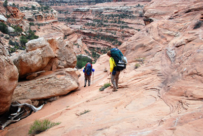
That was the plan, but it is easier said than done. First off, there was gully after gully to cross, even after we got to the high point. So you can not walk in a straight line ,and while we had set waypoints on both the western tip of the South fork and my estimate for where the seam was to get down into it, walking in this terrain toward a fixed point was challenging. Also, we were trying to avoid walking on any cryptogrammic soil, so tried our best to stay on game trails where they were available. This photo posted by Will provides a sense of the surroundings.
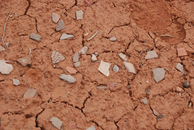
One thing that was pretty neat to find as we crossed the mesa were areas where it looked like pottery shards had been dumped. We did not dig around them, but came across several places where thirty or forty pieces of different Anasazi pots could be found. Just out in the middle of nowhere. That was about the only fun thing that we encountered. Ultimately, we arrived at a spot that looked like it had been "chained" many years ago. No cedar trees growing, just sage brush. It did give us an opportunity to get some improved line of sight compass headings as we finally approached the canyon rim.
 Despite the long arching route
we took to the edge of the South Fork, we nailed the descent point
pretty well, arriving at the canyon rim about 11:45 am. It had taken
us 90 minutes to cover a straight line distance of 1.3 miles. We
probably doubled that distance. Nevertheless, we were at the canyon
rim. It did not take long before Ron started down the seam. He got
down perhaps 150 feet and realized that scouting the route would be a
major endeavor, so asked for someone to bring him some food and water.
Andy volunteered. From the rim, we could see a couple of things worth
noting. First, lots of ruins on the north wall of the South Fork.
Kelsey mentions these in his Fifth Edition write up but it was nice to
see them, even from afar. Secondly, about 300 feet below the rim, up
in the west end of the South Fork, we could see pools of water and
what looked to be flat places. So we knew that even if we got down in
the canyon, and could not find a way down further, we could still
spend the night if needed, without a dry camp.
Despite the long arching route
we took to the edge of the South Fork, we nailed the descent point
pretty well, arriving at the canyon rim about 11:45 am. It had taken
us 90 minutes to cover a straight line distance of 1.3 miles. We
probably doubled that distance. Nevertheless, we were at the canyon
rim. It did not take long before Ron started down the seam. He got
down perhaps 150 feet and realized that scouting the route would be a
major endeavor, so asked for someone to bring him some food and water.
Andy volunteered. From the rim, we could see a couple of things worth
noting. First, lots of ruins on the north wall of the South Fork.
Kelsey mentions these in his Fifth Edition write up but it was nice to
see them, even from afar. Secondly, about 300 feet below the rim, up
in the west end of the South Fork, we could see pools of water and
what looked to be flat places. So we knew that even if we got down in
the canyon, and could not find a way down further, we could still
spend the night if needed, without a dry camp.
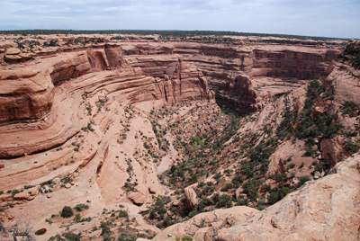
We filled our time taking photos and watching Ron and Andy look for routes down steep slickrock. Once one gets below the shelf about 300 feet below the rim, the going obviously gets more tricky. We could see Ron and Andy work along slickrock shelves, going back and forth, looking for the easiest way down. From this distance, they looked more like colorful ants. They eventually got below the 300 foot line, and we could see them trying to work their way toward some large cottonwoods, followed by what looked from the rim like a significant boulder jam. Sue handed me her binoculars, and said, "Rog, I think you'd better take a look." I took the binocs and looked through them at the boulder jam and said: "Oh shit!" We could see, from this distance, that there were some very huge boulders on the floor of the canyon and it was not obvious how to bypass them. But maybe Ron and Andy could find a way. But we did know that it was about 700 feet from the lip of the canyon to the floor of the main fork of McCloyd. While we waited, we all drank in the views. This fork of McCloyd is spectacular: deep, ruins, and the north wall of the fork that separates it from the main fork has these formations that look like huge gods sitting on thrones. If you gotta wait somewhere, this is a nice place to cool your heels.
Time was marching on, and by now, we were starting to push our comfort envelope. A bit after 1 pm, Andy and Ron started up, checking out some other things on the way back up. I figured that they might be deciding what might be easier paths to take on the way down. But when they finally climbed back up within earshot, it was in response to a yelled query that Ron made the slicing movement across his throat, and I knew we were rapidly shifting to Plan C. Ron and Andy would ultimately report that the route down across some slickrock was very steep in places and, while anything is possible, getting through the boulder jam just beyond the bright green cottonwoods would be very tough with backpacks. Huge steps, tight squeezes, and general unpleasantness. They both indicated that they needed some time to rest and eat and drink after their efforts. We thought back to Ron's passing out last year, and agreed that such was a good idea.
(I am going to roll back the clock for a paragraph or so. One of the "problems with having taken something like 25+ backpacking trips in these canyons over the past 29 years is that it is simply hard to remember, on any given day, what you have done previously, especially if it was a while ago. So it would take Will, who had been on my first trip into Owl and Fish canyons 18 years previously, another couple of weeks to recall his previous experience in McCloyd, as part of a day hike down from the confluence of Fish and Owl Creeks. It turns out that he had hiked all the way from that spot, down Fish to the mouth of the main fork of McCloyd and up McCloyd to the mouth of the side canyon (McCloyd's South Fork) into which we were trying to descend. He climbed up from the mouth to some ruins on the north wall, clearly near or past the boulder jam that was blocking our way down, and produced, upon returning home, the pictures and marked up maps to prove it. But he admits that things might have changed in the 18 years since he had been on that trip. Well, indeed they have, but I shall save that for later in this story, because it provides some explanation for what we had experienced and what we were about to experience.)
It was a few minutes before 2 pm when we finally saddled up, officially shifting to Plan C. Plan C involved hiking back across the mesa to our vehicles, driving ourselves around to the Owl Creek trailhead and descending into Owl Creek Canyon, with the ultimate thought that we could do the classic Owl/Fish loop trip. Most of us had already done all or part of that loop, but hey, we had a permit that allowed us to do what we now called Plan C, and we thought we had a chance of getting to the floor of Owl before dark, so why not? The first task was to hightail it across the mesa. Rather than completely retracing our steps to the 1.2 mile road that leads to the rim of McCloyd, we would veer off that route so as to take a more direct line to the vehicles. Well, that was the plan, but as usual, we took a less direct route, having to make micro-topographical adjustments along the way. Amazingly, we all made it back to the vehicles by 3 pm. And it only took Andy (in whose Jeep Commander Susie and I were riding) 35 minutes to drive the 8 miles of the Snow Flat road. It is easier the second time, and also, going up the rock shelves is easier than going down them (just like hiking).
 We arrived at the Owl Canyon
trailhead a couple minutes before 4 pm. We were greeted by a fellow
who was from near Wisdom, MT, who had been out day hiking and was
impressed with the climb out of Fish Creek. Sounds like this might
have been his first time in this kind of country. The other 6 had to
drive back to the ranger station, because they had used up all the
water they were carrying for the day, just doing what we had done
already. So they were a few minutes behind us. The four of us hoisted
and took off like the proverbial bats out of hell for the few hundred
meter walk to the Owl Canyon rim. As I had indicated, several of us on
the trip had experience with this route. Sue and Andy, on a
just-the-two-of-them trip in '84 had climbed out of Owl as part of a
north fork of Fish/Owl loop trip. Will, Barbara, John and I had
climbed into via Owl in '91 and Susie and I had done it in '93. So the
route should not have been a surprise.
We arrived at the Owl Canyon
trailhead a couple minutes before 4 pm. We were greeted by a fellow
who was from near Wisdom, MT, who had been out day hiking and was
impressed with the climb out of Fish Creek. Sounds like this might
have been his first time in this kind of country. The other 6 had to
drive back to the ranger station, because they had used up all the
water they were carrying for the day, just doing what we had done
already. So they were a few minutes behind us. The four of us hoisted
and took off like the proverbial bats out of hell for the few hundred
meter walk to the Owl Canyon rim. As I had indicated, several of us on
the trip had experience with this route. Sue and Andy, on a
just-the-two-of-them trip in '84 had climbed out of Owl as part of a
north fork of Fish/Owl loop trip. Will, Barbara, John and I had
climbed into via Owl in '91 and Susie and I had done it in '93. So the
route should not have been a surprise.
But it was. After the first couple of big steps that get your started, and a descent across some sloping slickrock, we noted that the new route (not a trail, by any means) did not take one past a kiva that we had seen in previous years. The kiva was still there, but the route was on the other side of the arm of the canyon. Hmm…….. And then we got to increasingly large boulders and rubble piles that had to be skirted or descended, respectively. The route takes one out on the right side of this arm of the canyon and descends some steep slickrock. We looked at each other and said: is this the same route, since none of us remembered having to take our packs off and using rope, or in this case, parachute cord, which was the only thing I had left with me for pack lowering? On the previous trip, I recall a spot where we took our packs off and just handed them down to the next person, who was standing on the immediate canyon floor. This time, it was slide roped packs down a steep slickrock slope to someone who was trying to figure out where to stash them, lest they roll off into the great beyond. Was it age (ours) or had something changed?
 Either way, it was slow going.
Ron had caught up to us and we left the cord for pack lowering with
him, while Susie and I pushed on. Susie and I eventually got to the
point where the Main Fork of Owl and the arm from which we had been
descending join and while the area was nice and flat, it was covered
with heavy vegetation (mostly reeds) and the water was in a deep
trench that made it tough to get down to. I thought it looked like a
fine place to camp, but, well, we all have different tastes. And this
area did not appeal to Susie. So we pushed on. In another quarter of
mile, we got to a spot that looked like it might work, but it would be
very tight. Big enough for six tents, if we squeezed, but of course,
we had seven tents. About this time, Sue caught up to us and said:
"Rog, I think you are about to have a mutiny on your hands, if you
don't stop." Andy asked the obvious question: "What was wrong with
that last campsite?" I just looked at Susie so as to reinforce the
question, but then answered diplomatically: "Well, Susie didn't like
it." (Good rule here: always blame something on your spouse,
especially if it is appropriate.) Anyway, the four of us agreed that
we could make this home for the night. It was way short of the spot
where I had planned to camp (near the big pouroff at the confluence of
the Main and South Forks of Owl Canyon), but let's face it: It had
taken us two hours (it was now after 6 pm) to cover 1.1 miles from the
trailhead, which gives one an idea of how we were moving. To stop here
proved to be an excellent decision, in light of what we would
experience.
Either way, it was slow going.
Ron had caught up to us and we left the cord for pack lowering with
him, while Susie and I pushed on. Susie and I eventually got to the
point where the Main Fork of Owl and the arm from which we had been
descending join and while the area was nice and flat, it was covered
with heavy vegetation (mostly reeds) and the water was in a deep
trench that made it tough to get down to. I thought it looked like a
fine place to camp, but, well, we all have different tastes. And this
area did not appeal to Susie. So we pushed on. In another quarter of
mile, we got to a spot that looked like it might work, but it would be
very tight. Big enough for six tents, if we squeezed, but of course,
we had seven tents. About this time, Sue caught up to us and said:
"Rog, I think you are about to have a mutiny on your hands, if you
don't stop." Andy asked the obvious question: "What was wrong with
that last campsite?" I just looked at Susie so as to reinforce the
question, but then answered diplomatically: "Well, Susie didn't like
it." (Good rule here: always blame something on your spouse,
especially if it is appropriate.) Anyway, the four of us agreed that
we could make this home for the night. It was way short of the spot
where I had planned to camp (near the big pouroff at the confluence of
the Main and South Forks of Owl Canyon), but let's face it: It had
taken us two hours (it was now after 6 pm) to cover 1.1 miles from the
trailhead, which gives one an idea of how we were moving. To stop here
proved to be an excellent decision, in light of what we would
experience.
And we thought that last night's camp was a squeeze?? Hah, we hadn't seen anything yet. The Butler/Fischer and McDonald/Jenkins contingent figured the only way to set this up was to put our two tents within a foot of each other. Well, you do what you have to. The upside of this campsite (12S, 605269 E, 4146610 N) was that the water was flowing and it was easy to get to. OK, places to undress and clean up and throw water up on the bank were limited ( I darn near wrenched my shoulder flinging a pot full of water away from the water source), but again, you do what you have to.
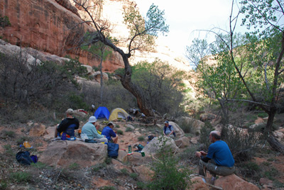 The troops started trickling in,
with Will and Kim pulling up the rear. Will repeated Andy's question,
and I repeated the answer. But I pointed out that we had "saved a
spot" for them downstream and on the other side of the creek, and
apparently, it turned out to be pretty good. After cleaning up, Susie
and I decided on one of our tastier dinners, pesto with penne and pine
nuts and lots of cheese. Sue had been gracious enough to give us some
chardonnay out of an extra bottle they had in the Jeep. Man, when
cleaned up after a long day, a bit of wine in the canyon bottom really
hit the spot. Susie took a few photos of nice lighting on the canyon
wall, but mostly, we relaxed (no campfires permitted) and chatted and
looked forward to getting up late in the morning. OK, about as late as
a bunch of mostly sixty-somethings can sleep.
The troops started trickling in,
with Will and Kim pulling up the rear. Will repeated Andy's question,
and I repeated the answer. But I pointed out that we had "saved a
spot" for them downstream and on the other side of the creek, and
apparently, it turned out to be pretty good. After cleaning up, Susie
and I decided on one of our tastier dinners, pesto with penne and pine
nuts and lots of cheese. Sue had been gracious enough to give us some
chardonnay out of an extra bottle they had in the Jeep. Man, when
cleaned up after a long day, a bit of wine in the canyon bottom really
hit the spot. Susie took a few photos of nice lighting on the canyon
wall, but mostly, we relaxed (no campfires permitted) and chatted and
looked forward to getting up late in the morning. OK, about as late as
a bunch of mostly sixty-somethings can sleep.
To view supplemental photos of this trip, go to our TwoHikers SmugMug gallery.
To view additional and different photos of the trip, go to Andy's and Will's Internet photo galleries.
© Roger A. Jenkins, Suzanne A. McDonald, 2009