
McCloyd, Owl and Fish Canyons 2009
Déjà vu all over again
House of Moons
Monday, April 27 With the sun not hitting camp until mid-morning, and it being 35 when we crawled out of the tents, I could tell this would be a leisurely morning. Can't remember when we got out of camp and started hiking, but the Exif information on the photos suggests something like 9:45 am. How decadent!! We hiked back upstream the 2/3 mile or so to the point where the route leaves the creek bottom and climbs up on some low benches that are maybe 20 feet above creek bed level. From there, we elected to take a brute force approach to climbing up to the primary ruin that is Moonhouse. Not sure why, except that it was obvious. It involves a bit of scrambling, but nothing difficult.
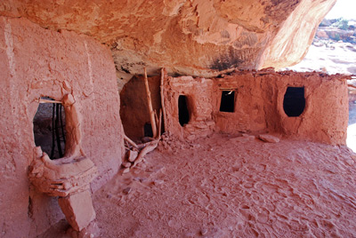 To say that Moonhouse is
impressive is an understatement. Several ruins, with an inner and
outer wall. The BLM permits people to climb through the outermost wall
of the ruin to get a look inside. We were still very careful, since we
did not want to be the ones that collapse a wall. If one takes one's
time, there are excellent examples of Anasazi construction techniques
that can be seen. It was even possible to photograph inside a couple
of the inner chambers without touching the entry-way walls. There is
some interesting painting of the rear wall in the main chamber, and
lots of stones used to decorate the wall. The first time I can
remember seeing such on Cedar Mesa.
To say that Moonhouse is
impressive is an understatement. Several ruins, with an inner and
outer wall. The BLM permits people to climb through the outermost wall
of the ruin to get a look inside. We were still very careful, since we
did not want to be the ones that collapse a wall. If one takes one's
time, there are excellent examples of Anasazi construction techniques
that can be seen. It was even possible to photograph inside a couple
of the inner chambers without touching the entry-way walls. There is
some interesting painting of the rear wall in the main chamber, and
lots of stones used to decorate the wall. The first time I can
remember seeing such on Cedar Mesa.
It should be noted here that beginning in 2010, the BLM is going to be restricting access in McCloyd Canyon even more so than they are doing now. I would strongly urge anyone interested to go sooner rather than later (with a permit of course. The trailheads are monitored by rangers.) We all spent a fair amount of time looking and photographing. We had seen dozens of ruins previously, but this one was pretty complex and special.
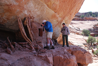 Upstream on the same side of the
canyon as Moonhouse and at the same level, there is a spire that
sticks out from the canyon wall near the end of a fin. Terri and I
decided to walk around it and see what could be seen. The answer is:
lots more ruins, especially on the same side as we were on. We decided
to try getting over to them. Looking on a map, it seems they can't be
further than maybe 300 meters, but it felt further. Looking at the
ruins from afar, they looked a bit busted up, but hey, what else did
we have to do today except look at ruins? Terri and I worked our way
around on the same approximate shelf level as Moonhouse, but
ultimately, these ruins upstream were at a lower level, probably at
least 100 feet lower. But working up and down, it is not hard to get
to them without having to drop all the way to the floor of McCloyd
Canyon. Anyway, the ruins were worth the trip. I yelled back to Susie,
who eventually followed us around, that they were worth it. There was
one spot that she was not comfortable going around, but otherwise,
pretty straightforward. The largest of the ruins appeared like a
collapsed above-ground kiva. The back wall of it was painted smoothly.
And there were several examples where you could see the stick
reinforcing of the mud around the doors and entryways.
Upstream on the same side of the
canyon as Moonhouse and at the same level, there is a spire that
sticks out from the canyon wall near the end of a fin. Terri and I
decided to walk around it and see what could be seen. The answer is:
lots more ruins, especially on the same side as we were on. We decided
to try getting over to them. Looking on a map, it seems they can't be
further than maybe 300 meters, but it felt further. Looking at the
ruins from afar, they looked a bit busted up, but hey, what else did
we have to do today except look at ruins? Terri and I worked our way
around on the same approximate shelf level as Moonhouse, but
ultimately, these ruins upstream were at a lower level, probably at
least 100 feet lower. But working up and down, it is not hard to get
to them without having to drop all the way to the floor of McCloyd
Canyon. Anyway, the ruins were worth the trip. I yelled back to Susie,
who eventually followed us around, that they were worth it. There was
one spot that she was not comfortable going around, but otherwise,
pretty straightforward. The largest of the ruins appeared like a
collapsed above-ground kiva. The back wall of it was painted smoothly.
And there were several examples where you could see the stick
reinforcing of the mud around the doors and entryways.
 We all turned around and headed
back to Moonhouse, mainly because it was getting hungry out here, and
I had left my day pack with lunch in it near Moonhouse. Susie and I
ate lunch at the interface between the shade and the sun (it was one
of those days) and chatted with Kim and Will who had found an easier
way up to Moonhouse (you go upstream of it, around the bend and climb
an easy rubble field. Will and Kim announced that they would be hiking
back up on to the mesa top, so she could call her son and see how his
election bid for sophomore class president went. Hard to say much
about that….. Meanwhile, Susie and I headed downstream on the same
shelf on which Moonhouse sits to look at some more ruins. The walking
was easy with virtually no exposure, and we saw several more ruins,
and got some good views down canyon. There was one multi-room dwelling
and a few single chamber structures, suggestive, to the untrained eye,
of grain storage. Very nicely preserved. Following that, we went back
upstream, found the easy descent route past Moonhouse and headed back
to camp. It had been a nice relaxing morning and early afternoon.
We all turned around and headed
back to Moonhouse, mainly because it was getting hungry out here, and
I had left my day pack with lunch in it near Moonhouse. Susie and I
ate lunch at the interface between the shade and the sun (it was one
of those days) and chatted with Kim and Will who had found an easier
way up to Moonhouse (you go upstream of it, around the bend and climb
an easy rubble field. Will and Kim announced that they would be hiking
back up on to the mesa top, so she could call her son and see how his
election bid for sophomore class president went. Hard to say much
about that….. Meanwhile, Susie and I headed downstream on the same
shelf on which Moonhouse sits to look at some more ruins. The walking
was easy with virtually no exposure, and we saw several more ruins,
and got some good views down canyon. There was one multi-room dwelling
and a few single chamber structures, suggestive, to the untrained eye,
of grain storage. Very nicely preserved. Following that, we went back
upstream, found the easy descent route past Moonhouse and headed back
to camp. It had been a nice relaxing morning and early afternoon.
 Susie and I decided to check out Barbara's
idea of an alternate route for getting out of McCloyd: there is a
small side canyon just upstream from camp that looks promising on a
map for getting out, but like they say, appearances can be deceiving.
Boy, it took us about 10 minutes to get to a huge jumble of rocks
which quickly decided for us that the way to get out was the way we
came in. Susie and I gathered up our bathing stuff and headed
downstream to where there was actually some water in pools on the rock
shelves (no water at all near camp). It was nice to run around and
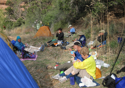
clean up while there was still some sunshine. We headed back to camp
and I worked on my diary while the rest of folks seemed to be living
it up in some sort of social hour near the dining area. Nothing like a
layover day…..
Susie and I decided to check out Barbara's
idea of an alternate route for getting out of McCloyd: there is a
small side canyon just upstream from camp that looks promising on a
map for getting out, but like they say, appearances can be deceiving.
Boy, it took us about 10 minutes to get to a huge jumble of rocks
which quickly decided for us that the way to get out was the way we
came in. Susie and I gathered up our bathing stuff and headed
downstream to where there was actually some water in pools on the rock
shelves (no water at all near camp). It was nice to run around and
clean up while there was still some sunshine. We headed back to camp
and I worked on my diary while the rest of folks seemed to be living
it up in some sort of social hour near the dining area. Nothing like a
layover day…..
It was over dinner (of beef stroganoff) that I began to realize that not only did I not have the rope attached to my backpack, but no one else in our party had it either. I became convinced that for some stupid reason, I had become distracted, as the last person in our party leaving the pack lowering part of the descent, and had simply forgotten to re-attach the rope to my pack. The carabiner was still attached, but neither the rope, nor the small yellow strap attached to it, was there. Andy and I tried to look at his photos, to determine if you could see the rope attached to my pack after I had left the critical spot. Unless we could find the rope on the way out, we were screwed, rope-wise. (As it would turn out, a photo of my pack from two sources suggested that I still had the rope on my pack at lunch time. It must have been after that when it was detached. Either way, I proved to be especially incompetent, and felt badly about such.
 One of the things we started
discussing was the amount of information we really had in our hands
concerning the pouroffs and bypasses. I had been told by a BLM ranger
(via phone, indirectly) that there were bypasses that had been
developed by hikers around the problematic areas. The Hiking Guide to
Cedar Mesa just refers to the pouroffs in McCloyd as "impassable."
Kelsey describes a route around the pour-offs, mentioning a "ladder"
and skinny ledge. But a very careful read of his description of a loop
trip through McCloyd reveals that he never mentions getting to the
floor of the main fork of McCloyd downstream of the pouroffs. He stays
several hundred feet off the floor of the Main Fork, and goes into the
South Fork fairly high. This does not come thru when you read the
description. Finally, the volunteer information folks at the Kane
Gulch ranger station had serious concerns about abilities of
backpackers to get around the pouroffs. He did say that we could get
into the canyon via the route Kelsey describes being able to use to
climb out. But Sue then remembered that he admitted he had never been
in or out of the canyon that way. The bottom line was, at this point,
that we had no clear idea that we could do the route that we were
planning on doing (down into lower McCloyd and hike out to the
confluence with Fish.) Uncertainty reigned.
One of the things we started
discussing was the amount of information we really had in our hands
concerning the pouroffs and bypasses. I had been told by a BLM ranger
(via phone, indirectly) that there were bypasses that had been
developed by hikers around the problematic areas. The Hiking Guide to
Cedar Mesa just refers to the pouroffs in McCloyd as "impassable."
Kelsey describes a route around the pour-offs, mentioning a "ladder"
and skinny ledge. But a very careful read of his description of a loop
trip through McCloyd reveals that he never mentions getting to the
floor of the main fork of McCloyd downstream of the pouroffs. He stays
several hundred feet off the floor of the Main Fork, and goes into the
South Fork fairly high. This does not come thru when you read the
description. Finally, the volunteer information folks at the Kane
Gulch ranger station had serious concerns about abilities of
backpackers to get around the pouroffs. He did say that we could get
into the canyon via the route Kelsey describes being able to use to
climb out. But Sue then remembered that he admitted he had never been
in or out of the canyon that way. The bottom line was, at this point,
that we had no clear idea that we could do the route that we were
planning on doing (down into lower McCloyd and hike out to the
confluence with Fish.) Uncertainty reigned.
To view supplemental photos of this trip, go to our TwoHikers SmugMug gallery.
To view additional and different photos of the trip, go to Andy's and Will's Internet photo galleries.
© Roger A. Jenkins, Suzanne A. McDonald, 2009