
McCloyd, Owl and Fish Canyons 2009
Déjà vu all over again
Lower McCloyd revealed
Thursday, April 30 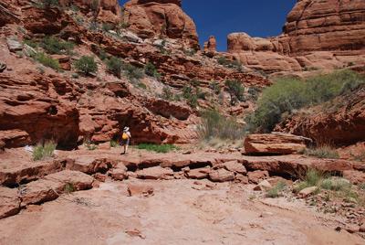 It was 36 when we woke up. Kinda slows down the
caterpillars. For a bit. We slept really well last night, probably
because it was cool and because we were tired. It's not like we were
moving big distances, but rather, the heat and the soft sand just
takes it out of us. Maybe more than it did 16 years ago. Why would
that be?? (Actually, review of the photos from the trip 16 years ago
suggested that warmth was not a problem.)
It was 36 when we woke up. Kinda slows down the
caterpillars. For a bit. We slept really well last night, probably
because it was cool and because we were tired. It's not like we were
moving big distances, but rather, the heat and the soft sand just
takes it out of us. Maybe more than it did 16 years ago. Why would
that be?? (Actually, review of the photos from the trip 16 years ago
suggested that warmth was not a problem.)
We had a relaxed morning, chatting over breakfast. Eight of us left camp about 9:35, heading down Fish Creek. We crossed tall benches and occasionally encountered water, but within a few hundred meters of the mouth of McCloyd, the stream bed was dry. It was about at this point that Susie decided she would rather focus on the works of Mother Nature (ie, scenery in lower McCloyd) than the works of man (Anasazi ruins in lower Fish). That was fine with me, (since we had seen some of the lower Fish Canyon ruins on our previous trip)so we broke off from the main group once we got to the official mouth of McCloyd. We decided to stay in the stream bed for a while, because the walls were fairly high. But that did not last very long. While Susie was behind me, increasing nitrogen availability to the local flora, I moved forward and came across a huge pile of tumbleweed, so big it filled the entire stream bed up to the top of the steep walls. So I worked with my trekking pole to push enough out of the way to get thru. After a couple of hundred meters, eventually, the walls because sufficiently shallow that we could climb out and up on the benches. Things moved along a bit more quickly then.
 In the lower part of McCloyd,
the canyon is pretty wide, and the benches fairly sandy. Despite the
fact that there is a strong path headed upstream, the going is slow,
and not real interesting. However, after about 1.3 miles or so, the
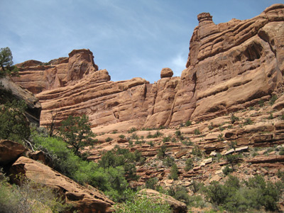
canyon begins to narrow, and while one is still crossing benches, up
and down, the scenery improves considerably: some nice hoodoos and
canyon walls. By 11:45, we had reached, something like 3.5 miles from
camp (and about 2.4 miles above the mouth of McCloyd) the mouth of
what Kelsey calls the South Fork of McCloyd. This is the short branch
of McCloyd that we had attempted to descend into two days before.
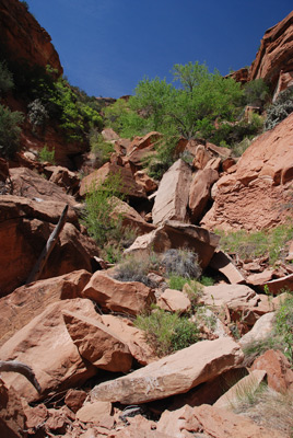
Susie led the way, and worked to get close to get to the boulder jam
that had blocked our scouts' progress on Tuesday. It did not look any
easier from the downstream side. We could see the rim where most of us
had waited on Tuesday, and looked for an obvious path thru the boulder
jam, past room-sized and near-small-house sized boulders. Nothing
revealed itself. That does not mean that you could not get thru,
especially with a day pack. Rather, the question is: how hard do you
want to work.
In the lower part of McCloyd,
the canyon is pretty wide, and the benches fairly sandy. Despite the
fact that there is a strong path headed upstream, the going is slow,
and not real interesting. However, after about 1.3 miles or so, the
canyon begins to narrow, and while one is still crossing benches, up
and down, the scenery improves considerably: some nice hoodoos and
canyon walls. By 11:45, we had reached, something like 3.5 miles from
camp (and about 2.4 miles above the mouth of McCloyd) the mouth of
what Kelsey calls the South Fork of McCloyd. This is the short branch
of McCloyd that we had attempted to descend into two days before.
Susie led the way, and worked to get close to get to the boulder jam
that had blocked our scouts' progress on Tuesday. It did not look any
easier from the downstream side. We could see the rim where most of us
had waited on Tuesday, and looked for an obvious path thru the boulder
jam, past room-sized and near-small-house sized boulders. Nothing
revealed itself. That does not mean that you could not get thru,
especially with a day pack. Rather, the question is: how hard do you
want to work.
We both took a look at the south wall of this branch, near where it
joins with the main fork of McCloyd. It appeared that it might be
possible, when descending from the mesa, to stay on the south wall
most of the way to the mouth of the branch, avoiding the boulder jam.
 If I had nothing else to do
that day, I might have scouted it. But we did have things to do, and
doubted we would be back here, so we moved on. We moved over to the
north side of the branch, and re-entered the main fork of McCloyd. You
can tell right away that there is water nearby, because the amount of
vegetation increases dramatically. We came across a small campsite in
the main fork, with shade, big trees, and enough spots for four tents.
It looked kinda nice, and would make a good base camp for climbing up
into the South Fork and looking at ruins. (Note: after the trip, Will,
who recalled hiking up into lower McCloyd back in 1991, showed me
where there is a ruin up on canyon right in the Main Fork, immediately
across from the mouth of the South Fork, which we completely missed.
It is in one of our photos, but we did not notice it at the time. Oh
well.) Water is present in the canyon bottom right above the camp, and
the vegetation continues to thicken. We pushed on, working our way
around some boulders, trying to get to what we suspected is the first
blocking pouroff going upstream. At one point, we had to climb up a
wet wall to get to the next level (we found an easier way on the way
down).
If I had nothing else to do
that day, I might have scouted it. But we did have things to do, and
doubted we would be back here, so we moved on. We moved over to the
north side of the branch, and re-entered the main fork of McCloyd. You
can tell right away that there is water nearby, because the amount of
vegetation increases dramatically. We came across a small campsite in
the main fork, with shade, big trees, and enough spots for four tents.
It looked kinda nice, and would make a good base camp for climbing up
into the South Fork and looking at ruins. (Note: after the trip, Will,
who recalled hiking up into lower McCloyd back in 1991, showed me
where there is a ruin up on canyon right in the Main Fork, immediately
across from the mouth of the South Fork, which we completely missed.
It is in one of our photos, but we did not notice it at the time. Oh
well.) Water is present in the canyon bottom right above the camp, and
the vegetation continues to thicken. We pushed on, working our way
around some boulders, trying to get to what we suspected is the first
blocking pouroff going upstream. At one point, we had to climb up a
wet wall to get to the next level (we found an easier way on the way
down).
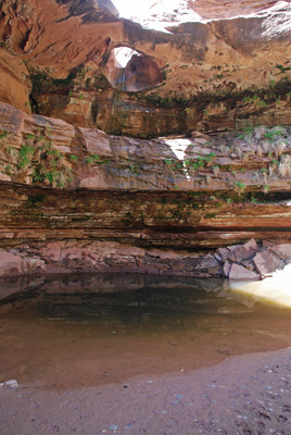
Less than 250 meters above the campsite, we finally came to the blocking pouroff. I tried taking a GPS reading, but it was impossible to get more than one satellite. The walls are high and straight, but I estimate that the pouroff is near 12S, 608710 E, 4142702 N. The pour off may be 30 to 40 feet high, and has a large pool right below it. The neatest thing is that there is a large hole, making what is technically a natural bridge, worn into the floor (or top) of the pouroff. It is reminiscent of the big hole in the Golden Cathedral in Neon Canyon in the Escalante system. We tried taking photos, but the lighting was extremely difficult. We found a couple of rocks to sit on and had some welcome lunch. It was way past due. Afterwards, we took the opportunity to load up on semi-potable water (we treated 4.5 liters) and left the lunch spot sometime around 1:30 pm.
 When we moved out into the
broader part of the canyon, we could tell that the day had gotten
toastier. It was 3.5 miles back to camp, and while we moved at a
pretty good clip, and bypassed going all the way down to the official
mouth of McCloyd (opting to stay close to the north wall as we
approached the mouth), it still took us until nearly 4 pm to get to
the general vicinity of camp. We were looking to find the "cleaner
pool" downstream a bit from the "spring" that feeds the water flowing
past camp. We treated more water and headed back thru the shintangle
to camp. Susie was hot and decided to clean up, while I thrashed back
through the bushes, etc, to fill our large water bag. This was the
biggest negative about this campsite: tougher to get to water.
When we moved out into the
broader part of the canyon, we could tell that the day had gotten
toastier. It was 3.5 miles back to camp, and while we moved at a
pretty good clip, and bypassed going all the way down to the official
mouth of McCloyd (opting to stay close to the north wall as we
approached the mouth), it still took us until nearly 4 pm to get to
the general vicinity of camp. We were looking to find the "cleaner
pool" downstream a bit from the "spring" that feeds the water flowing
past camp. We treated more water and headed back thru the shintangle
to camp. Susie was hot and decided to clean up, while I thrashed back
through the bushes, etc, to fill our large water bag. This was the
biggest negative about this campsite: tougher to get to water.
Following Ron's lead, I took his route back to camp, but this required two really steep climbs up sandy benches, always the thing you want to do with 20+ pounds of water in your hand. Oh well. Anyway, after cleaning up and doing a bit of laundry, I finally sat down about 5:30 pm, and chatted with Ron and John a bit. Susie enjoyed relaxing in the noseeum-free zone inside our tent before dinner. Covering 7+ miles, even on just a day hike, in this heat required some recovery and re-hydration. Dinner was around 6:15 and we tried something slightly different with the Orzo, chicken and peas. Susie boiled everything for a bit, and then just let it all sit to absorb the liquid. The pasta cooked perfectly and it was not soupy. A bit under-spiced, thanks to me, but not soupy. We mostly sat around, sharing stories of the day, while Will and Kim cooked dinner in the dark. Everyone likes different things. I think it took us past 9:30 or so to finally get in the sack, but I think part of the delay was that it was much warmer this evening.
To view supplemental photos of this trip, go to our TwoHikers SmugMug gallery.
To view additional and different photos of the trip, go to Andy's and Will's Internet photo galleries.
© Roger A. Jenkins, Suzanne A. McDonald, 2009, 2016