
McCloyd, Owl and Fish Canyons 2009
Déjà vu all over again
Up and Out
Saturday, May 2 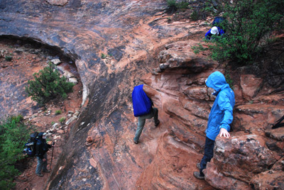 We awoke a bit after 1 am to some pitter patter on our
tent, and this time, it was rain, not caterpillar fecal matter. Not
hard rain, but wet nonetheless. We battened down the hatches, made
sure our packs were covered and got back in the tent. Shower after
shower came over in the next five hours. I confess I did not sleep as
well as I should have, thinking that if this got worse, a) the climb
out could be really sloppy and b) the road out to the highway from the
trailhead, where it crosses a wash, could be really nasty.
We awoke a bit after 1 am to some pitter patter on our
tent, and this time, it was rain, not caterpillar fecal matter. Not
hard rain, but wet nonetheless. We battened down the hatches, made
sure our packs were covered and got back in the tent. Shower after
shower came over in the next five hours. I confess I did not sleep as
well as I should have, thinking that if this got worse, a) the climb
out could be really sloppy and b) the road out to the highway from the
trailhead, where it crosses a wash, could be really nasty.
At 6 am, we could hear others stirring, and it was light enough to do some things in the tent, so we got up, started stuffing sleeping bags and other gear, and organizing what we could inside the tent. When we got outside, it had stopped, briefly, for this wave of showers, and we were pleasantly surprised to see the ground pretty dry. Just an example of when you are lying inside a drum (in this case, a nylon tent), the pounding always sounds worse. We cooked breakfast right near the tent. OK, what that means is that we heated some water for coffee and ate granola and freeze dried strawberries mostly standing up. Occasionally, a brief shower would remind us that the weather could deteriorate at any time.
 Most everyone was rolling by
7:30, far ahead of the appointed hour. It looked like Will and Kim
were going to be leaving at the latter time, but they have a way of
hauling ass when they really need to. The route up and out of Fish
Creek is steep, and that is an understatement. It climbs something
like 600 feet in a little over a quarter of a mile. The route is well
marked with cairns, and is not hard to follow if you are paying
attention and have the big picture in mind. Naturally, not long after
we left camp, the skies opened up. Not like it rains in the
southeastern US, but pretty significant by
non-thunderstorm-in-the-desert conditions. Of course, such added to
the slipperiness of the dirt and the slick rock. In a couple of spots,
you do have to cross slickrock, and the waterfalls that were starting
to develop all around the canyon walls made crossing the slickrock
tricky. I recall one spot where the slickrock was especially steep.
There was a large overhanging rock on the right, which made it
impractical to hold on as you ascended. I got up (it was not pretty)
with my pack on, while Susie handed her pack up to the side through
some rocks, and climbed the steep slickrock sans pack. We climbed up
above this spot, yelled down to Barbara and Terri, who were just
beginning the climb, with suggestions. Terri started up, but then got
stuck, not wanting to go up and concerned about backing down. I
suspect that the wet conditions had a lot to do with her level of
confidence. Anyway, Andy trotted back down the path to assist, and she
was just fine.
Most everyone was rolling by
7:30, far ahead of the appointed hour. It looked like Will and Kim
were going to be leaving at the latter time, but they have a way of
hauling ass when they really need to. The route up and out of Fish
Creek is steep, and that is an understatement. It climbs something
like 600 feet in a little over a quarter of a mile. The route is well
marked with cairns, and is not hard to follow if you are paying
attention and have the big picture in mind. Naturally, not long after
we left camp, the skies opened up. Not like it rains in the
southeastern US, but pretty significant by
non-thunderstorm-in-the-desert conditions. Of course, such added to
the slipperiness of the dirt and the slick rock. In a couple of spots,
you do have to cross slickrock, and the waterfalls that were starting
to develop all around the canyon walls made crossing the slickrock
tricky. I recall one spot where the slickrock was especially steep.
There was a large overhanging rock on the right, which made it
impractical to hold on as you ascended. I got up (it was not pretty)
with my pack on, while Susie handed her pack up to the side through
some rocks, and climbed the steep slickrock sans pack. We climbed up
above this spot, yelled down to Barbara and Terri, who were just
beginning the climb, with suggestions. Terri started up, but then got
stuck, not wanting to go up and concerned about backing down. I
suspect that the wet conditions had a lot to do with her level of
confidence. Anyway, Andy trotted back down the path to assist, and she
was just fine.
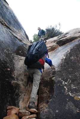
The crux of the climb out of the canyon is a crack in the capstone on
the canyon rim. It is about 15 - 20 feet up through the crack, and not
particularly dangerous. But it does take some effort and maybe a few
four letter words. In the past, we have always sent someone up without
a pack and used a rope to haul packs and steady people as they climb.
Having done this twice, I was interested to see how well our 16 years
(or 18 years) older bodies would do. Ron was first up the crack and he
seemed to do it with minimal problem and not having to take his pack
off. Not to be outdone, Susie, who has to be a foot shorter than Ron,
began climbing, and bingo, she was at the top. Ultimately, we all
would do the climb (using some tree roots as a handhold) successfully
without removing our backpacks. About the time that the first 8 of us
had topped out, Will and Kim were waiting at the bottom of the crack
for their chance to climb it. Whew, they must have sprouted wings and
flown up.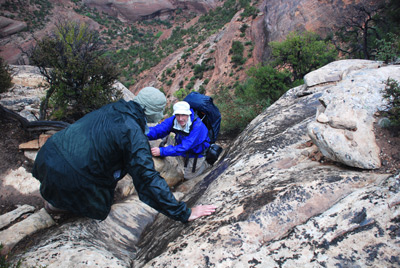
It was 9 am when we all topped out, 90 minutes to go a quarter of a mile or so. Such is hiking in canyon country. The rain probably slowed us down for a few minutes, but not terribly. It was a good time for a pee break and then we took off, headed for the trailhead. The path climbs about 100 feet right away, and then begins to make a slow descent back toward the trailhead. It crosses several gullies in the 1.5 miles or so from the Fish Canyon rim. The trail is not exactly as it is marked on the USGS quad, but it is easy to follow, and moves along quickly.
 When we arrived at the trailhead
about 9:45 am, we encountered several things. First, Andy and Sue's
vehicle had a flat tire. (They had noticed it was losing air on the
way in, but could not find compressed air in Blanding. It turns out
that this was a previously repaired tire, and their rental agency did
not charge them, but they still had to change the flat.) While A&S
were figuring out how to change the tire, we chatted with the
volunteer couple that we had met previously at the Visitor Center.
Also, there was a ranger who is usually stationed at the Escalante
Visitor Center (Boy, she was a long way from home. It is over 200
miles by road between visitor centers.) We mentioned to her that we
had found the descent into Owl much more tricky and time consuming
than we had 16 years or 18 years ago. She agreed, and indicated that
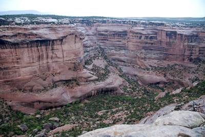
the great
canyon country flood of October, 2006, which did such a number
on the Escalante system, had washed down lot of boulders, forcing the
BLM to relocate routes all over canyon country. So now, it became
clear: the boulder jam in the South Fork of McCloyd, the first descent
into Owl, the route around the big pouroff before we got to the
confluence of the north and main forks of Owl, the number of rocks and
boulders in the upper part of Fish. Even though the great Escalante
flood was 75 miles away by air, it has had an impact all over canyon
country, as we noted both in
2007 and 2008.
When we arrived at the trailhead
about 9:45 am, we encountered several things. First, Andy and Sue's
vehicle had a flat tire. (They had noticed it was losing air on the
way in, but could not find compressed air in Blanding. It turns out
that this was a previously repaired tire, and their rental agency did
not charge them, but they still had to change the flat.) While A&S
were figuring out how to change the tire, we chatted with the
volunteer couple that we had met previously at the Visitor Center.
Also, there was a ranger who is usually stationed at the Escalante
Visitor Center (Boy, she was a long way from home. It is over 200
miles by road between visitor centers.) We mentioned to her that we
had found the descent into Owl much more tricky and time consuming
than we had 16 years or 18 years ago. She agreed, and indicated that
the great
canyon country flood of October, 2006, which did such a number
on the Escalante system, had washed down lot of boulders, forcing the
BLM to relocate routes all over canyon country. So now, it became
clear: the boulder jam in the South Fork of McCloyd, the first descent
into Owl, the route around the big pouroff before we got to the
confluence of the north and main forks of Owl, the number of rocks and
boulders in the upper part of Fish. Even though the great Escalante
flood was 75 miles away by air, it has had an impact all over canyon
country, as we noted both in
2007 and 2008.
Our trip was wrapping up. As quickly as the group had convened in Blanding the week before, the chicks were all scattering. We waited with Andy and Sue to insure that their tire changing went ok (it took them less than 30 minutes - I was impressed) before we met Barbara and the rest of the Knoxville crew at the Kane Gulch Visitor Center. The Knox 5 were busy unloading and moving gear, using the paved parking lot as a much better place to do so. Boy, the place was packed. There was what appeared to be a guided group, starting a backpack by hiking across the road, into the rain and showers and Kane Gulch itself. We felt sorry for them, because the weather did not look good for another day or so. The line for the pit toilets was enormous, and there was a general hubbub. Barbara reported she was heading to the Natural Bridges National Monument campground, the Knox 5 were headed to Santa Fe via Mexican Hat, and Sue and Andy were headed to their second home in Pagosa Springs, CO, via the Subway in Blanding. Susie and I had the shortest drive that afternoon, through the rain and showers to Moab, where we would hike in Canyonlands the next day. We agreed to meet A&S at the Subway, for a cost-effective (read: cheap) lunch. Driving across the Comb and Butler wash in the showers, I was glad that we did not have to spend the night out tonight, with thin mud being the only source of water. The four of us had been there, done that, in the upper reaches of Dark Canyon in the fall of 2005. Once was enough. No déjà vu this time.
To view supplemental photos of this trip, go to our TwoHikers SmugMug gallery.
To view additional and different photos of the trip, go to Andy's and Will's Internet photo galleries.
© Roger A. Jenkins, Suzanne A. McDonald, 2009, 2016