
McCloyd, Owl and Fish Canyons 2009
Déjà vu all over again
Up Fish
Friday, May 1 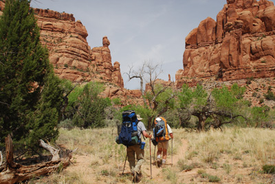 We awoke to 41 degrees, after a night of pitter patter
of caterpillar droppings. My sense is that the day would be warmer,
simply because the evening had been so as well. I had draped one of
the shirts I had laundered over a couple of downed tree branches
yesterday evening, and the amount of chewed up leaves and caterpillar
crap on the shirt was amazing. We had a reasonably relaxing
pre-breaking-camp breakfast, chatting and joking with our friends, and
photographing a little lizard on Barbara's ground cloth that actually
decided to be still and allow these giant humans to capture its image.
We awoke to 41 degrees, after a night of pitter patter
of caterpillar droppings. My sense is that the day would be warmer,
simply because the evening had been so as well. I had draped one of
the shirts I had laundered over a couple of downed tree branches
yesterday evening, and the amount of chewed up leaves and caterpillar
crap on the shirt was amazing. We had a reasonably relaxing
pre-breaking-camp breakfast, chatting and joking with our friends, and
photographing a little lizard on Barbara's ground cloth that actually
decided to be still and allow these giant humans to capture its image.
But alas, not too much goofing off, as we had miles to cover, heading up Fish Creek Canyon to just above the confluence of its North and South Forks. We hoisted at 9:16 and Susie, John and I took off together. As an astute reader may have noticed, on canyon trips, the group usually spreads out quite a bit, usually over the course of a mile or two. Everyone likes to hike at a different pace, explore different places, take different numbers of photos and rest breaks, etc. Pretty much, the decision is made the night before where we will plan to camp the next day, and people take off when they feel like it. We only stay together when the going requires such.
 Even though I had backpacked up
Fish Creek twice before, heck, things seem both familiar and new as
one hikes along. I was glad, however, that many of us had some degree
of familiarity with the canyon, simply because I had no map of the
entire Fish Canyon system. Since originally, there had been no plan to
hike in the upper reaches of Fish canyon, I had not brought a detailed
24K scale quad with me. In retrospect, I now realize that I had
violated one of my own rules: Always carry an overview map of the
entire area where you are hiking, so if an abort is required,
necessitating a walk out to a different road system, one can do such
intelligently. Why I had not at least packed my Trails Illustrated
Grand Gulch Plateau, or printed out a custom overview map of the area,
I have no idea. I kicked myself mentally all the way up the canyon,
but it did not speed my progress. Fortunately, John, who has not
gotten into digital custom mapping, just brought his old fashioned,
paper Snow Flat Spring Cave USGS quad with him, so at least we had
something.
Even though I had backpacked up
Fish Creek twice before, heck, things seem both familiar and new as
one hikes along. I was glad, however, that many of us had some degree
of familiarity with the canyon, simply because I had no map of the
entire Fish Canyon system. Since originally, there had been no plan to
hike in the upper reaches of Fish canyon, I had not brought a detailed
24K scale quad with me. In retrospect, I now realize that I had
violated one of my own rules: Always carry an overview map of the
entire area where you are hiking, so if an abort is required,
necessitating a walk out to a different road system, one can do such
intelligently. Why I had not at least packed my Trails Illustrated
Grand Gulch Plateau, or printed out a custom overview map of the area,
I have no idea. I kicked myself mentally all the way up the canyon,
but it did not speed my progress. Fortunately, John, who has not
gotten into digital custom mapping, just brought his old fashioned,
paper Snow Flat Spring Cave USGS quad with him, so at least we had
something.
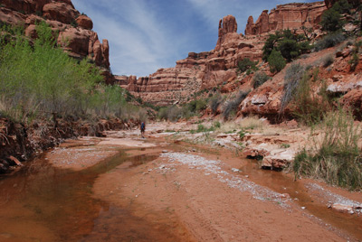
 For the first couple of miles
above the confluence of Owl and Fish, there is no water in the canyon
bottom. This was not a surprise, given that this has been a much drier
spring than what Susie, George and I experienced 16 years ago. But by
11:45 am or so, we had gone far enough upstream that small amounts of
water began to appear in the stream bed, and the canyon began
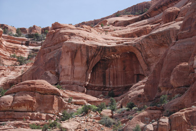
tightening up. We had passed a neat arch about 15 minutes previously
that lots of folks miss. It is canyon right as one heads upstream, and
it is easy to miss if the lighting is not right. I happened to catch
it because some of the wall behind it was illuminated by sunlight.
Many of our party did miss it.
For the first couple of miles
above the confluence of Owl and Fish, there is no water in the canyon
bottom. This was not a surprise, given that this has been a much drier
spring than what Susie, George and I experienced 16 years ago. But by
11:45 am or so, we had gone far enough upstream that small amounts of
water began to appear in the stream bed, and the canyon began
tightening up. We had passed a neat arch about 15 minutes previously
that lots of folks miss. It is canyon right as one heads upstream, and
it is easy to miss if the lighting is not right. I happened to catch
it because some of the wall behind it was illuminated by sunlight.
Many of our party did miss it.
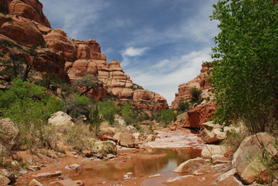
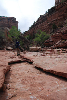
As the canyon gets tighter, the walls seem more dramatic, and there are more and more spires and hoodoos. Pretty neat. We had more time to view them, because I noticed that we were starting to slow down a bit. When the canyon walls tighten up and they are in full sun, they radiate heat at you. So you are getting it from every direction. Also, I noticed that we were having to pick our way around rocks in the stream bed, big ones and small ones. It just made the going a bit slower. Occasionally, we would encounter long slabs of slickrock, and the ease of forward motion would improve.
 A few minutes or so after the
arch, we decided we needed some shade and a lunch break. Ron had just
pulled out of some shade under a large boulder. There was not much
else shade, so his spot looked just fine. It was nice to have water
flowing by us. We were starting to have problems with our SteriPen. It
would simply not work. Pretty frustrating, but of course, we never
hike without pills. The darn thing simply would give an error signal
every time I stuck it in water, and also, just turning it on would
give an error signal. I vowed to write the manufacturer when we got
back home. [I subsequently did some searching on the internet and
learned I was not the only one experiencing this problem. Apparently,
the pen, after some use, gets damp and does not perform adequately. To
me, this is real bullshit, but I have not yet rattled the
manufacturer's cage. I. (Of course, when we got home, the pen worked
perfectly. Intermittent problems are always the toughest to resolve.)]
A few minutes or so after the
arch, we decided we needed some shade and a lunch break. Ron had just
pulled out of some shade under a large boulder. There was not much
else shade, so his spot looked just fine. It was nice to have water
flowing by us. We were starting to have problems with our SteriPen. It
would simply not work. Pretty frustrating, but of course, we never
hike without pills. The darn thing simply would give an error signal
every time I stuck it in water, and also, just turning it on would
give an error signal. I vowed to write the manufacturer when we got
back home. [I subsequently did some searching on the internet and
learned I was not the only one experiencing this problem. Apparently,
the pen, after some use, gets damp and does not perform adequately. To
me, this is real bullshit, but I have not yet rattled the
manufacturer's cage. I. (Of course, when we got home, the pen worked
perfectly. Intermittent problems are always the toughest to resolve.)]
Another piece of technology that was not being particularly useful today was my GPS. No fault of the GPS. It just turned out that the satellite constellation at lunch time was not positioned well, and the high canyon walls were providing a lot of signal bounce. I have written about signal bounce elsewhere and if you are totally reliant on the location the GPS reports, without using a bit of common sense - and map/terrain reading skills - it can really throw you off. For example, on this afternoon, the GPS was reporting that we were perched a couple of hundred feet off the floor of the canyon. According to it, we would have had to be clinging on the edge of a sheer face. Not likely, for sure. So when I reported our position to John and Susie, I drew a really big circle on the map, after looking around to make sure that the canyon was at least running in the same direction as the GPS was reporting. OK, so here we are, plus or minus a few hundred meters. Anyway, my position estimate suggested that we had at least 3 more miles to cover, which would take a while, give our pace of progress. So no matter how inviting the shade was, it was time to hoist and move up the canyon. Hey, at least the scenery was distracting. In fact, it was hard to beat.
In this part of Fish Canyon, there are few large bends in the walls. Pretty much a straight shot to the north-northeast, until the canyon turns to the west and heads for the fork between the north and south forks. While I had hiked this before, it did feel somewhat different. I kept looking for a large pool in which I had taken a dip years previously, but never found it. We were stopping about every hour for a rest break, just to give our legs a break. We stopped about 3:30 and noted, based on visual observation (I did not even bother with the GPS) that we were only a quarter to a third of a mile from the canyon spit. That made us feel good, since camp was only a half mile beyond the split, so we were just a few minutes away. Right? Well, not exactly.
 The vegetation at the split
requires some work arounds, as do the rocks. Just seemed to be more
boulders in the route. We had to work to get around some pools, and I
kept thinking: I sure hope that our planned campsite is still usable.
At one point, we had to scramble up a rock shelf, using a small tree
as a hand hold. We continued to push on, climbing around boulders.
About 4:30 pm, I noticed Ron ahead of us about 100 meters and above
our position considerably. He saw us and yelled down that we had
arrived. Since I knew we were still a ways from where I had thought
about camping (under a rock shelf where we had spent the night in
1991) I was interested to see what he had found. The answer was: a
pretty darn good campsite, on three levels: Main floor, mezzanine, and
second floor. It had been heavily used, but at least it was better
than where I had planned to camp. A lot more space, good water nearby,
and a large rock shelf on which to cook dinner. Location: 12S, 605550
E, 4150394 N, or for those readers who don't use a GPS, it is on
canyon right, immediately across from the point where small cairns
indicate that the "trail" begins a steep climb to exit Fish through
the famous slot.
The vegetation at the split
requires some work arounds, as do the rocks. Just seemed to be more
boulders in the route. We had to work to get around some pools, and I
kept thinking: I sure hope that our planned campsite is still usable.
At one point, we had to scramble up a rock shelf, using a small tree
as a hand hold. We continued to push on, climbing around boulders.
About 4:30 pm, I noticed Ron ahead of us about 100 meters and above
our position considerably. He saw us and yelled down that we had
arrived. Since I knew we were still a ways from where I had thought
about camping (under a rock shelf where we had spent the night in
1991) I was interested to see what he had found. The answer was: a
pretty darn good campsite, on three levels: Main floor, mezzanine, and
second floor. It had been heavily used, but at least it was better
than where I had planned to camp. A lot more space, good water nearby,
and a large rock shelf on which to cook dinner. Location: 12S, 605550
E, 4150394 N, or for those readers who don't use a GPS, it is on
canyon right, immediately across from the point where small cairns
indicate that the "trail" begins a steep climb to exit Fish through
the famous slot.
After setting up our tent, Susie and I headed back downstream to a large chunk of slickrock with some water running over it. A great place to clean up, some vegetation nearby into which to throw rinse water, and clean rock on which to walk. Life was good. We did not start cooking dinner until 6:15. It was not quite as cool, probably because high thin clouds were moving in. Tonight was end-of-the-trip Portrait Night, always good for lots of picture taking, laughing, and giving each other a hard time. I was a bit concerned about Ron. He had lost his appetite again. We gave him a couple of extra Cup-o-Soups and he mostly just relaxed through dinner. We chided him that we did not want any repeats of last year, so he laid down on his sleeping pad and took a nap, so he would not pass out and hit his head on the way down. Will and Kim, of course, waited until way after dark to cook. They made a massive amount of Mac and Cheese. It looked pretty darn good. I guess I was getting depleted. We left them finishing up dinner and hit the sack. The plan was to get up at 6:15 am and roll no later than 8:15. It was not like we had a huge distance to hike, but the climb out of Fish can take a while, and half the crew were headed all the way to Santa Fe after we got back to the cars.
To view supplemental photos of this trip, go to our TwoHikers SmugMug gallery.
To view additional and different photos of the trip, go to Andy's and Will's Internet photo galleries.
© Roger A. Jenkins, Suzanne A. McDonald, 2009, 2016