
McCloyd, Owl and Fish Canyons 2009
Déjà vu all over again
More changes...
Wednesday, April 29 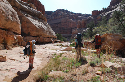 I, the first of the tired little puppies, started
getting up around 7 am, but not many others were stirring for another
30 minutes. Today had been originally planned as a layover day, and
Susie reminded me of such as I responded loosely to the query how many
miles do we have to hike today. My response had been "six or 7 miles,
not sure" but that seemed inadequate. (It would turn out to be 6, but
of course, six miles in the heat and loose sand is different than 6
miles in a cool, shady forest in the mountains. At least the footing
is a helluva lot better in the latter.) No one seemed to be in a
hurry, and that was likely in part to my response to Terri, when she
asked me what was next in the canyon. I indicated it was maybe a half
mile or more of walking in slickrock, going around to the left on a
shelf and then plunge stepping through soft sand to the floor of the
canyon and the base of the pouroff that we were skirting. From there,
it was all easy down to the confluence - and below - with Fish Creek.
But as they say, that was then (or at least, 16 years ago) and this is
now.
I, the first of the tired little puppies, started
getting up around 7 am, but not many others were stirring for another
30 minutes. Today had been originally planned as a layover day, and
Susie reminded me of such as I responded loosely to the query how many
miles do we have to hike today. My response had been "six or 7 miles,
not sure" but that seemed inadequate. (It would turn out to be 6, but
of course, six miles in the heat and loose sand is different than 6
miles in a cool, shady forest in the mountains. At least the footing
is a helluva lot better in the latter.) No one seemed to be in a
hurry, and that was likely in part to my response to Terri, when she
asked me what was next in the canyon. I indicated it was maybe a half
mile or more of walking in slickrock, going around to the left on a
shelf and then plunge stepping through soft sand to the floor of the
canyon and the base of the pouroff that we were skirting. From there,
it was all easy down to the confluence - and below - with Fish Creek.
But as they say, that was then (or at least, 16 years ago) and this is
now.
 Anyway, we had some breakfast of
instant oatmeal (hey, it's calories) and coffee and some sort of
Crystal Lite breakfast-like drink mix, and broke camp at a relaxed
pace. We were hoisting at something like 9:45 or a few minutes
earlier. As to the slickrock walking from camp to the pouroff, well,
at least the last couple hundred meters is slickrock. But first, it is
brush, and big rocks. Essentially, there is no place for camping
between where we camped - which was marginal - and the pour-off at the
first "Falls" marked on the topo maps. We waited just a bit and took a
few photos at the approach to the falls and then focused on the
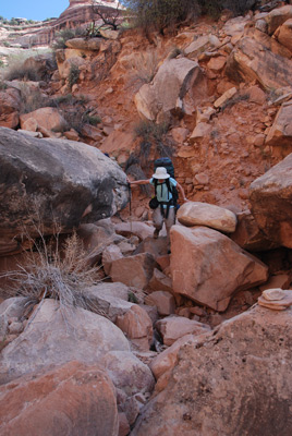
bypass. I remember looking over on the opposite side of the shelf on
which we were walking, where the soft sand route was supposed to be,
and seeing nothing but rubble. I also remember thinking: boy, the
slickrock feels more outwardly sloped than I remember it. But instead
of going around the head of the arm that bypasses the pouroff and
getting into soft sand, the route just sorta jumps off into the bottom
of the wash, which is, naturally, filled with boulders. What happened
to the easy descent? It felt like things had just washed away.
Anyway, we had some breakfast of
instant oatmeal (hey, it's calories) and coffee and some sort of
Crystal Lite breakfast-like drink mix, and broke camp at a relaxed
pace. We were hoisting at something like 9:45 or a few minutes
earlier. As to the slickrock walking from camp to the pouroff, well,
at least the last couple hundred meters is slickrock. But first, it is
brush, and big rocks. Essentially, there is no place for camping
between where we camped - which was marginal - and the pour-off at the
first "Falls" marked on the topo maps. We waited just a bit and took a
few photos at the approach to the falls and then focused on the
bypass. I remember looking over on the opposite side of the shelf on
which we were walking, where the soft sand route was supposed to be,
and seeing nothing but rubble. I also remember thinking: boy, the
slickrock feels more outwardly sloped than I remember it. But instead
of going around the head of the arm that bypasses the pouroff and
getting into soft sand, the route just sorta jumps off into the bottom
of the wash, which is, naturally, filled with boulders. What happened
to the easy descent? It felt like things had just washed away.
It took us about an hour to get from camp to the base of the pour-off. It is a lovely spot, with a nice pool and a good spot for several tents. It is the first really good campsite since entering the canyon (and much better than the area at the confluence of the South and Main Forks of Owl Canyon). We took some photos, but most everyone else was ready for a break, so Susie and I moved on. It was the last we would see of anyone until we neared our campsite in mid-afternoon.
The next attraction is the big pouroff and pool at the confluence of
the South and Main Forks of Owl canyon (the second "falls" marked on
the topo map. Certainly worth a stop to see, but getting to the level
of the pool takes some doing, as we would soon learn. You bypass the
pool and pouroff on canyon left (headed downstream) and you have to
walk in rocks and on ledges for about 400 meters above the floor of
the canyon before you can descend to the floor of Owl. It took us
about 20 - 25 minutes to make the 400 meters. 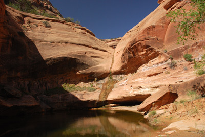 (One of the great things about Exif information in the
jpeg images you capture with a digital camera is that you know exactly
when you were at what spot.) When we finally got to the canyon floor,
we did decide it was time for a short break and some water. We had not
carried a lot of water with us this day, because we knew we would have
water for the first couple of hours of our hike. Then, it would be dry
until we nearly got to camp.
(One of the great things about Exif information in the
jpeg images you capture with a digital camera is that you know exactly
when you were at what spot.) When we finally got to the canyon floor,
we did decide it was time for a short break and some water. We had not
carried a lot of water with us this day, because we knew we would have
water for the first couple of hours of our hike. Then, it would be dry
until we nearly got to camp.
For a while, the route (don't want to call it a trail) on the canyon floor has plenty of vegetation and boulders that require a bit of negotiation. We could feel the day warming up. In deep canyons with full sun, warm can get "hot" quickly. It was getting that way. We stopped at a spot where we felt like we would run out of water. In fact, actually, we went past the spot and felt like I needed to go back 150 meters or so to get water to top off our hydration systems. We had been using a Steri-pen on this trip, rather than a pump/filter system, simply because of the formers much lighter weight. Occasionally, the device would not work, but most of the time, when you plunged it into a Lexan bottle, the UV treatment light would come on, and the DNA of all the little single cell critters in the water would get scrambled. We probably left the water hole with 3.5 liters between us, and our bellies full.
 When the water runs out (or
actually, goes below ground), the canyon broadens a bit and vegetation
as an issue is replace by soft, unconsolidated sand. Think walking on
a beach above the high tide line. Yeah, it is great for the shape of
your calves, but it takes a lot of effort, especially with a pack on.
In addition to it getting warm out, it was also getting hungry, and
with shade at a premium, we decided to stop across the canyon from
Neville Arch in the shade of a cotton wood about 12:35. It felt good
to eat and drink more than a sip at a time. Neville Arch is dramatic.
Virtually every trip report you see of Owl Canyon has a photo of the
arch. I am sure that it is possible to get up to it, but not on a warm
day like today.
When the water runs out (or
actually, goes below ground), the canyon broadens a bit and vegetation
as an issue is replace by soft, unconsolidated sand. Think walking on
a beach above the high tide line. Yeah, it is great for the shape of
your calves, but it takes a lot of effort, especially with a pack on.
In addition to it getting warm out, it was also getting hungry, and
with shade at a premium, we decided to stop across the canyon from
Neville Arch in the shade of a cotton wood about 12:35. It felt good
to eat and drink more than a sip at a time. Neville Arch is dramatic.
Virtually every trip report you see of Owl Canyon has a photo of the
arch. I am sure that it is possible to get up to it, but not on a warm
day like today.
Lunch was short, just because the longer we sat, the later it would be when the hiking was over for the day. The heat and sand just was not as much fun as it sounds. We hoisted at 1 pm, and motored on down the canyon. It was hard to keep up with Susie. We hiked for about 50 minutes and found a shady tree for another rest break. When I got out the GPS, I exclaimed: "No wonder we are tired!" We were only 400 meters or so above the confluence with Fish Creek. The tree bark was really neat on this old cottonwood and Susie spent a bit of time photographing it. From there, we headed for the confluence, where we had camped on my last two trips. A nice campsite, but no water, as expected (In 1991, there had been no water there either, but a mile or so downstream, there was. In 1993, a bit earlier in the season, there was water at the confluence.) In the ranger station, they had a map showing where the water ran out in Owl and where it ran out in Fish. I knew, however that there was an active spring a ways below the confluence. So that is where we headed, now starting to look for places to camp.
About a half mile below the confluence, Sue and Andy caught up to us.
So we started looking jointly for campsites. In the distance, we could
see the kind of vegetation that one might expect to see around
permanent water, and so we pushed on. We crossed a bench and dropped
into some tall, dried grasses that Andy said were last year's grasses,
so we figured we should be able to find a place to camp. Sure enough,
we walked through a grove of cottonwoods, and we found a huge place to
camp (12S, 611611 E, 4142243 N). It had lots and lots of space,
privacy zones around individual tent sites, and water in the creek
nearby. It was 3 pm, so give the slowness of the first part of the
day, such was not too bad for getting to camp.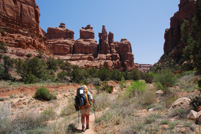
However, the downside of the site was caterpillars, specifically the tent caterpillars that eat cottonwoods. Millions of them. One had to be careful of where one set one's tent up. Otherwise, it would be covered with caterpillars dropping out of the trees. As our tent was after leaving it for just a few minutes to check out the water source. Susie insisted that we move the tent to a location not far away (maybe 10 feet) but I must say, the tent move kept a lot of the critters off the tent. Another less appealing part of the site was the water. There was water there, but it was not flowing very fast and as a result, looked scummy and a bit cloudy. But it was wet and clean enough for frogs, crawfish, and little minnows, so it could not be too bad (as long as you don't mind crawfish crap in your water. Sue checked out the "spring" that fed this part of the creek and she indicated the pool immediately downstream of the "spring" was equally or more skuzzy. However, the pool below it was somewhat better. However, to get to that pool was a bitch. Anyway, we were home for a couple of nights. Thankfully.
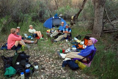 Susie and I cleaned up and were
getting the dinner spot in order. It was quite some time before Terri
and Barbara showed up, and they indicated they had just been taking
their time. It was well after 5 pm when, as we were sitting around
what would be the dinner spot, we heard Ron calling from somewhere.
Apparently, he and John had stayed on the right side of the canyon,
crossing the creek bed where the spring was, and had gone by the spot
(on canyon left) where we would camp. I guess we were easy to miss,
and shielded by vegetation, tough to see or hear. We did not expect
Kim and Will for awhile. Other indicated that the two of them had
dropped their packs and decided to go up the South Fork of Owl, as
there were supposed to be ruins a mile and a half up it. It was not
the thing I would have chosen to do on a day this warm, but to each
his own. They ultimately arrived in camp at 7:30 pm. A very long day
for them, but they like seeing lots of places. Kim was the instigator,
and Will kept saying this did not seem like a good idea, but they
burned a lot of time going a short distance in Owl. Again, to each his
own. By the time they cleaned up and cooked dinner, it was getting
pretty late, and Susie and I were not in tentia until nearly 10 pm. We
fell asleep to the pitter patter of droppings on our tent, droppings
being the frass, or caterpillar fecal matter, and the partially eaten
leaves. How lovely...
Susie and I cleaned up and were
getting the dinner spot in order. It was quite some time before Terri
and Barbara showed up, and they indicated they had just been taking
their time. It was well after 5 pm when, as we were sitting around
what would be the dinner spot, we heard Ron calling from somewhere.
Apparently, he and John had stayed on the right side of the canyon,
crossing the creek bed where the spring was, and had gone by the spot
(on canyon left) where we would camp. I guess we were easy to miss,
and shielded by vegetation, tough to see or hear. We did not expect
Kim and Will for awhile. Other indicated that the two of them had
dropped their packs and decided to go up the South Fork of Owl, as
there were supposed to be ruins a mile and a half up it. It was not
the thing I would have chosen to do on a day this warm, but to each
his own. They ultimately arrived in camp at 7:30 pm. A very long day
for them, but they like seeing lots of places. Kim was the instigator,
and Will kept saying this did not seem like a good idea, but they
burned a lot of time going a short distance in Owl. Again, to each his
own. By the time they cleaned up and cooked dinner, it was getting
pretty late, and Susie and I were not in tentia until nearly 10 pm. We
fell asleep to the pitter patter of droppings on our tent, droppings
being the frass, or caterpillar fecal matter, and the partially eaten
leaves. How lovely...
To view supplemental photos of this trip, go to our TwoHikers SmugMug gallery.
To view additional and different photos of the trip, go to Andy's and Will's Internet photo galleries.
© Roger A. Jenkins, Suzanne A. McDonald, 2009, 2016