
Upper Escalante/Boulder Mail Trail 2006
Two Halves Trying to Make a Whole
Lower Death Hollow
Monday, May 1 Oh, it is always great to have a relaxing not-have-to-move-camp day. It was cool, but not cold this morning. Some of the crew sat around in the mezzanine level, while Susie and I, Andy and Sue, and Robin - and belatedly, Kim and Will, sat around on the ground floor of the campsite having breakfast and chatting. By the time we finished socializing and packed our day packs, it was after 9 am. Because of how the campsite was oriented, we had to cross the river twice to get up in the mouth of Death Hollow (DH). The river was up again overnight (it had started to settle and clarify late in the evening) and the difference between the muddy water of the Escalante, and the crystal clear water of Mamie Creek, coming down Death Hollow, was dramatic. (The contribution to the river flow is probably 30 - 50%.) John, Terri, Barbara, and Robin were up ahead of us, and Sue and Andy were moving about the same pace that Susie and I were. Ray was around somewhere, and Will and Kim were still relaxing over breakfast.
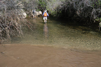 The first stretch of lower DH is pretty straightforward. While the water had cooled down overnight, I have been in lots colder water, for sure. The floor of the stream bed was relatively flat rock, and while the water was ankle to lower calf deep, and flowing toward us, the surer footing made progress easy. However, in a couple of hundred yards, we attempted to get up on the bench on canyon right, and found it covered with poison ivy. Now, I guess it is appropriate to provide some additional details. The poison ivy with which I had greatest familiarity is the southeastern variety, which grows on vines and little plants, maybe 6 -12 inches high. In contrast, the poison ivy we saw in DH, just beginning to leaf out, grows on woody stems up to 6 feet high, with the woody stems separated 6 - 8 inches. In other words, if you see it close up, you are probably already in a patch of it. Sue had checked out the bank, and then I went up, and it was clear that a) we were going to have to be vigilant and b) we were likely to be walking in water most of the time today.
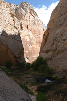 Lower Death Hollow is a photographers paradise. Big walls, some nice water, lots of monkey flowers and a few pools. The slickrock streambed was covered by water, but because it was so clear, the difficulty of bypassing the holes and pools was minimal. If the water had been muddy, lower DH would be very tricky and hazardous to hike. We moved slowly, because there were so many things to photograph. It was also a good time to chat. It took us probably 90 minutes or so to make it upstream a mile, where we found a large overhang and campsite for a couple of tents, and a nice spring to boot. Oh yes, we also found another mega-patch of poison ivy. Once you get a mile or so about the mouth of DH, the walls get really dramatic. Tight in and straight up. Make for challenging and lovely photography. Again, very few places to hike poison ivy-free up on the benches, so this is a wet walk.
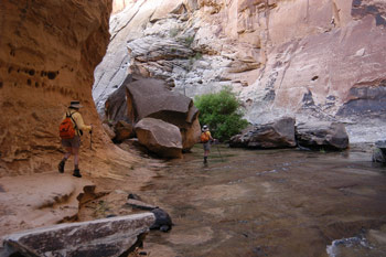
We made another few bends in the canyon and came to what for me would be the turning around point. The canyon narrows down: no benches, just water and walls. There are many deep pools in the rock that one needs to be careful in one's negotiation around. We ran into John coming down stream and he was pretty wet. He said he was tired of getting wet up past his crotch, signifying that things were getting deeper and more difficult to skirt. Shortly after this, we came to a very deep (maybe 12 - 15 feet) pool that spanned most of the canyon. Getting around it would require a leap off what was a pretty slippery step to another slightly sloped (and underwater at this water level) foot step, and then about three steps of moderately sloped slickrock which one would have to friction walk. Under normal circumstances, I would have said to myself: Hey, the worse that can happen here is that I would slip and fall into this nice, lovely pool of water and cool off. Which I will probably want to do before the end of the day, anyway. However, with a nice digital SLR in a camera holster on my left hip, and a left knee that was not working as well as I should have, I was giving the potential moves second, third, fourth and fifth thoughts. About this time, Andy and Sue pulled up behind us, and I showed them the problem move. (Again, no problem if the only thing that gets wet is you.) Andy had a lot more digital SLR gear and lenses with him that I did with me. And I am sure, way back in the recesses of Sue's mind, were the potential consequences of a wrong move on a slippery rock. Susie told Sue if we had not brought up the potential problem, they probably would have hopped across and never given it a second thought. Andy, wearing his camera gear bag like a 8 month pregnant woman wears her baby-to-be, expressed that he was not so sure about that conclusion. Susie and I turned around, and left the two of them to their decision making.
 Immediately, Susie and I ran into Kim and Will, headed upstream. They were moving slow, and I knew Will would be pushing to get as far up Death Hollow as he could. I told them we would see them by dinner time, and to be careful. Meanwhile, Susie had decided on a small sandy spot that had just become sunny and was free, more or less, from poison ivy. We sat and ate lunch, and watched as Sue and Andy returned around the bend, signifying that at least one of them had decided that without a dry bag, going for a swim with camera gear was not that great an idea. Great minds, and all that ...... As we moved back down Death Hollow, I reflected on the relative arbitrary nature of deciding what areas ought to be included in National Parks. I kept thinking that lower Death Hollow was every bit as good as the Virgin River Narrows through Zion, without so many people. There is so much good stuff out in this part of the country, and such a small fraction of it has received the protection and notoriety that it deserves. As Will often says: take everything in Utah South of I-70 and east of I-15 and make it into one large National Park. Sounds like a plan to me.
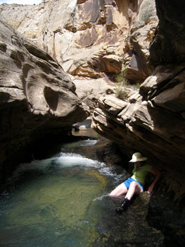
We got back to camp about 2:20 and it seemed prudent to bathe and get water, as clouds seem to be building. After cleaning up, we spent the remainder of the afternoon sitting around chatting with John and Terri, and collecting reports from folks as they wandered back into camp. Will would report that, by being willing to wade deep pools and keep pushing, he and Kim were able to get within perhaps a quarter mile of where Mamie Creek flows into the gorge of Death Hollow. It should be noted that the amount of time to make substantial progress up the gorge, against the flow of the current (since one is in the water almost constantly) is such that it would likely take someone a day to make it from the mouth of Death Hollow to the point where the Mail Trail crosses. That is, a day if you don't want to stop and take many photos or enjoy things. Of course, one can always eat a banquet in ten minutes, too.
Dinner was accomplished wearing rain gear. It never got to a really soaking rain, but it was enough to make you want to be sure you had pulled down your tent fly. Following a repast of pesto cavatapi and chicken, with homemade almond biscotti and hot spiced cider for dessert, the remainder of the evening was spent chatting. Dodging occasional rain drops.
© Roger A. Jenkins, 2006; Photo of person skirting pool © William H. Skelton, 2006