
Upper Escalante/Boulder Mail Trail 2006
Two Halves Trying to Make a Whole
Up the Escalante
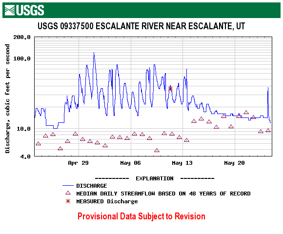
Sunday, April 30 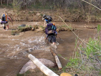 We were up before 6 am, doing final gear sorting and loading. We wanted to be at the motel-associated restaurant when it opened at 7, since we knew that eleven of us hitting the place at the same time would be a challenge for the cook and waitress. But we were on our way, bellies and cargo areas full, slightly after 8 am. First stop was the Grand Staircase - Escalante Visitors Center. We learned two things there: first, it is no longer necessary to stop by the Visitor's Center to pick up a hiking permit. Now, you can sign up at the trailhead registers. Secondly, the water at the gaging station was running at 58 cfs (cubic feet per second). Now maybe it is important to understand what this all means, and what it does not mean. First and foremost, the Visitor Center gets its flow information from the same USGS web link as above. The gauging station is NOT located anywhere near where we would be hiking that day, but rather 15 miles upstream of the Highway 12 bridge (near the mouth of Pine Creek), where we planned to start our hike.
Note that this is something like 7 river miles above where Mamie Creek dumps the flow out of Death Hollow into the Escalante, and maybe 11 miles above where Sand Creek Dumps its flow into the river. 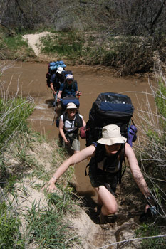 The distance can dampen the pulse of the flows. Now, it should be noted that mean flow at the gauging station for this time of year is on the order of 14 - 17 CFS. So clearly, the river - at the gauging station, 7 - 15 miles upstream from where we would be hiking that day, was running about 4 times normal. On the other hand, "normal" is usually ankle deep. Now, why does the Visitor Center rely on a flow gauge that is located immediately downstream of a tributary (Pine Creek) that is known to vary wildly in its flows, instead of someplace (like near the Highway 12 bridge) where the water contributed by major side creeks (eg. Mamie and Sand) be measured? Simply because it is the only stream gauge on the Escalante. Probably, the measurement is useful in a relative sense. That is, if flows at the gauging station are running 4x above normal, the side creeks, due to snow melt, rain, etc, are probably running stronger, and thus, when you to into the water (less than a hundred feet from the parking lot at the Highway 12 bridge), you can expect a strong flow. But in an absolute sense, the data is pretty worthless.
Having just driven over the Highway 12 bridge the night before, and seeing that the river looked doable, and there having been no precipitation that evening, I figured that we were not going to be in the situation we found ourselves in last year, having to re-route the trip at the last minute. So I listened politely to the woman who was providing me advice, and warning me that the water in Death Hollow was really cold. I assured her that we had been in relatively high water in the Escalante before and we would not be afraid to abort the trip for safety reasons. She also warned us that we would have to stay in the water of Death Hollow where it was crossed by the Boulder Mail Trail because of large amounts of poison ivy on the stream banks. For that warning, she was oh-so-on-target!!!
We left the Visitor's Center after a quick bathroom stop and headed to the Highway 12 crossing of the Escalante River. The original plan for this trip was to hike up the Escalante from the bridge, turn up Pine Creek, climb the plateau and hike the Boulder Mail Trail (BMT), coming out near the former Boulder airport. Allowing for a layover day at the mouth of and BMT crossing of Death Hollow, we planned to take a week. 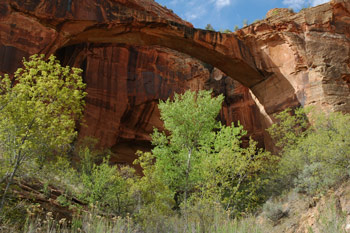 Sort of a "V-shaped" trip. However, saddled with my knee problem, Susie and I had decided we would hike in the first 7.5 miles to the mouth of Death Hollow, layover with the entire group, then turn around, hike back down to the mouth of Sand Creek, and spend our third night. We would hike out to our car the next morning, and drive up to the Boulder end of the Mail Trail, hike in to its crossing with Sand Creek, spend the night there, then on to Death Hollow, where we would meet up with the rest of the crew coming across the plateau. We would spend a layover at the BMT crossing of Death Hollow, then head with everyone back to Sand Creek, and then go out on Sunday morning. For me, what this meant was missing one full day going up river, followed by a second hard day climbing up on the plateau, a lot of which involved slickrock hiking, and likely to be harder on the knee. Anyway, that was the plan. One of the small advantages to our modified trip with the rest of the group is that we would effectively be running the car shuttle (placing a vehicle at the end of the trail) on our own time, and not waste group time early the first morning. I was trying to look for bright spots.
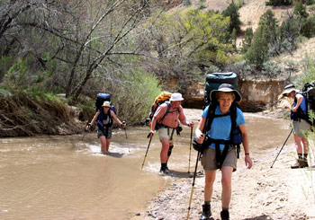
Obviously, hiking the Escalante from the Highway 12 crossing is popular at this time of year. We took the last three parking spots at the trailhead. I thought to myself: boy, there is going to be major competition for campsites. We all saddled up and were rolling by 9:15. Always nice to get a reasonably early start. But we did not keep dry feet for long. Within a hundred feet of the parking lot, the trail crosses in the river in the first of its 30 crossings between Highway 12 and just upstream of the mouth of Death Hollow. This first crossing would prove to be the trickiest. Some boulders, and small but deep holes, and because the river is narrow at this point, it would prove deeper there than virtually any other crossing we made. The water looked pretty unappetizing as well, more like thin mud, with quite a bit of small pieces of debris in it. But we got across fine, and headed up canyon. The first couple of miles is pretty smooth sailing, with only a few crossings. Within an hour, we had made it up to Escalante Natural Bridge. This is a huge natural bridge on the south wall of the canyon, perhaps 1.75 miles from the trailhead. It even looks like a bridge, with a flat top and arched underside. Next on the scenery list was a large ruin "complex" (it had at least two structures we could see from the ground, and a large snake-like red pictograph, several feet in length) perhaps only 300 - 400 meters upstream from the natural bridge. Surprisingly, it was on a north facing wall. And then just around the bend was an arch, high up on the south wall of the canyon.
 All of this scenery was "distracting," and slowed our pace somewhat. Nevertheless, we arrived across from the mouth of Sand Creek around 11:05. We had read that there was a good spring just up into Sand Creek perhaps 200 meters, so that seemed like a good place to stop, and load up with water for the rest of our trek to the mouth of Death Hollow. Now, getting to the spring takes some work, or better yet, familiarity with the route. First off, there is a lot of vegetation near the mouth of Sand Creek. At the time, Sand Creek was contributing maybe 30% of the total river flow, which suggests permanent water. We tried what turned out to be a relatively brushy route on the left side of Sand Creek - once we figured out how to cross the river. We wanted to stay on the left, since the spring is supposed to be on the left side of Sand Creek. That required a fair amount of thrashing, and we did have to avoid a small rattle snake that looked at Andy and me, and decided that we were too ugly to fool with and slithered back into the bushes. Eventually, we came across the spring, a nice dripping one, great for filling water bottles. On the way back to where we dropped our packs, we found a much more obvious route. It crosses Sand Creek, follows the east bank past a small campsite, and crosses the river perhaps 100 meters below the actual mouth of the creek. And naturally, there is a strong path on the south bank of the river that leads back to where we dropped our packs. The spring is very nice, and the guidebooks say it provides the best water in this stretch of the Escalante. I would not dispute that, at least until one gets down to the crack spring just below the mouth of The Gulch, which is perhaps 18 miles downstream of the mouth of Sand Creek.
By the time we got our water, drank some more, rested and saddled up, it was 11:45. We hiked until maybe 12:30 or so before stopping for lunch in a shady spot. The shade was welcome, because with the air temperature in the high 70's, the sun felt pretty hot. But no worry, we would get a chance to cool down as we crossed the river. About a mile above the mouth of Sand Creek, the canyon tightens considerably. The primary effect this has on hiking is to make it more challenging. First, the number of river crossings per mile increases, which really slows progress. Secondly, there are fewer hard-packed sand benches on which to make time. The vegetation is much thicker, and requires negotiation. So the routine is to follow the strongest path upriver. When one comes to a crossing, you look down the steep bank (which is often 3 or 4 feet down, but can be 7 or 8 feet), descend gently - if "gently" is possible, probe the water depth with a trekking pole, send the people behind you to a less-deep spot, go into the water, carefully crossing (remember that under these conditions, the water was maybe 4x higher than normal) to the other side, scramble up a wall-like sand embankment, help lift up the person behind you, and continue on your hike. Not a prescription for fast progress, but this was my sixth trip up at least part of the Escalante River, so no surprises for me. On the other hand, for Terri (whose only canyon hiking experience had been in the Grand Canyon), it was pretty "interesting."
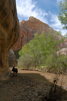
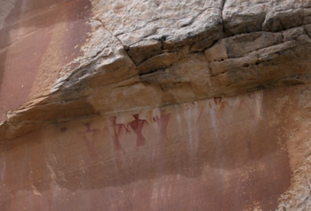 Susie spied a nice panel of pictographs along the north wall of the canyon, across a sandy bench. It gave everyone a chance to pull up and take a short breather. We pulled into the vicinity of the mouth of Death Hollow about 3:15 pm. Fairly leisurely pace, but again, it was toasty in the sun. We had run into a couple of fellows near the mouth of Sand Creek who told us about a nice campsite about a mile up Death Hollow. However, no one had much interest in going up another mile. We dropped our packs and explored just a bit. Right across from the mouth of the Hollow, there was a single tent campsite. Downstream 100 - 150 meters were some places with scattered shade, but then the ground was not too flat. The couple camping across from the mouth indicated that upstream and on the north bank of the river were several areas that were flat and had shade. We ended up opting for that. Half of the group seemed to be in the lower level, and half the group camped up on a small bench about 100 meters upstream. We were spread out because we could take advantage of shade and grassy spots. So my knee had held up for the first 5 hours of hiking. After that, I could feel the soreness creeping in. I felt like I had done pretty well. While not setting any speed records, I was able to keep up with most of the group, and really, such was about as good as I could have anticipated. Sue had counted 29 river crossings this day (we would count 30 on the way back down river). The act of crossing the river was not hard for me, but descending and ascending the steep banks was very knee-demanding, and I was glad to be here for the night. Or rather, two nights.
Susie and I went up into Death Hollow, the water being much clearer and appealing. The stream bottom was flat rock, so that provided a relatively stable bathing area. Nice, but not sunny. By the time we bathed and did laundry, it was 5:35 and time to start thinking about dinner. Unfortunately, the only place to cook was on either side of the path leading upriver. But it was not like the hoards were hiking this late in the afternoon. We hated the fact that our campsite was right on the trail, but you do what you have to. Our homemade Santa Fe chicken and rice needed a few more spices (not quite enough chili powder and cumin) but it was otherwise tasty.
 Probably the most interesting incident of the day happened at dinner. Will and Kim sat down at the dinner spot just about the time most of us were finishing up. Will had his new Swedish Nova backpacking stove with him. (Looks a bit like an MSR Whisperlight.) I think he had used it on a trip on the West Coast Trail (western side of Vancouver Island) last August. Anyway, he decided to bring the stove on this trip. We noticed he seemed to be having some problems with setting up the stove and had white gas all over his hand. Now, perhaps a bit of background on Will. Will is one of Knoxville's most well known and respected attorneys. Attorneys, in my opinion, see the law as something to be interpreted. Something that may be flexible, and bend to the will of a judge or a competent attorney. That is why we have so many of them. They all seem to want to interpret the law. So I was not too surprised when Will told me that, while the directions for the stove said explicitly to always use the fuel bottle provided with the stove, he had decided that the bottle did not hold enough fuel, so he brought his large MSR fuel bottle, and a smaller MSR fuel bottle, instead. To me, there is not much to "interpret" about "you MUST use THIS fuel bottle. But I am not an attorney. So when he screwed the fuel pump into the fuel bottle, he could not get a tight seal, and so the fuel would leak out. Not a good situation to be in with a camp stove, unless you are big time into self-immolation. Will tried several of the MSR fuel bottles that were in camp, but, not surprisingly, they all leaked. Unfortunately, for Will anyway, many of the participants in the trip had recently switched over to canister stoves, such as the Snow Peak Gigapower. I am not sure why these have become so popular, except that they are easy to turn on, and there is virtually no maintenance associated with them. Only Susie and I, Andy and Sue, and Barbara were using liquid fuel stoves on this trip, in addition to Will and Kim. Barbara admittedly had allowed her Whisperlight to get clogged up (the space filling steel cable had become heavily carbonized). Ray was working to try to fix the stove, without a lot of success, and with Susie and I leaving the group after another night, the only liquid fuel stove still operational and available was Andy and Sue's Whisperlight. The canister fuel people had only brought sufficient fuel to boil small amounts of water for freeze dried dinners and other minor cooking, not the more typical vegetarian cooking that Will does. Ironically, Will had suggested to me that I bring along (on the trip, but not the backpack) an extra backpacking stove, in case an over zealous, chemistry-challenged TSA screener prevented someone from bringing their stove on the trip. So back in our vehicle, we had an MSR Dragonfly (great stove if you can tolerate the jet-engine-like sound.)
And we had another issue: in all the switching of gear bags this morning, Barbara had inadvertently left all of her prescription meds in our vehicle. Stuff she really should not stop taking for a week. So we really had to work on a way to get the backup stove and the medicine to the appropriate members of our party the day we would get back to our car. I drifted off to sleep that night mulling the whole thing over, but not too hard.
© Roger A. Jenkins, 2006; First river crossing photo © Robin Ferguson, 2006; Natural bridge photo © Andrew P. Butler, 2006; Second river crossing photo © Barbara Allen, 2006; Pictograph photo © Suzanne A. McDonald, 2006