
Upper Escalante/Boulder Mail Trail 2006
Two Halves Trying to Make a Whole
Back to Sand Creek
Saturday, May 6 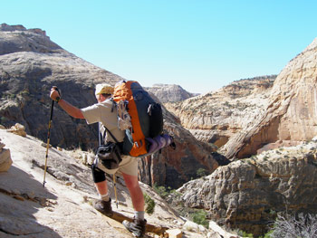 We crawled out of bed a bit before 7 am, and were greeted with 39 degree temperatures. Love the cool weather. Since we did not have a big day ahead of us, we extended the breakfast social hour, and Susie and I did not pull out of camp until 9:25. We were able to rock hop the creek, it being nice to be able to keep our boots, and mainly our socks, dry for the climb out of Death Hollow. Not surprisingly, we were last out of camp, except for Kim and Will. I knew I would be going slow, since climbing on hard rock with this knee would not be as comfortable as I would have liked. Susie and I had described to everyone the general route, and no one had any particular problem on the climb. The one exception was Sue. Susie and I were several hundred feet below her at the time, and we could see her walking gingerly back towards the remainder of the group. I could not discern exactly where she was, but Sue reported this: As she climbed up the path that is the "crux," she was, not surprisingly, paying close attention to the placement of her feet. She did not look up for some time, thinking that the crux might be longer than we had described to her. Apparently, she missed a small cairn that marks the point where, on climbing, you have to make a hard left turn into a shallow drainage, and, thankfully, move away from the rim. So she proceeded straight ahead, but noticed that the footing was getting increasingly precarious. Andy, who was behind her, yelled ahead something to the effect that it must be she was not having enough challenge, since she was obviously not on the "official" route. At that point, she stopped, looked around, and looked back at the route she would have to take to get back to the spot where she should turn into the drainage, and thought: "Oh, shit!" But she gingerly negotiated the much more exposed route, and had no more problems.
 Having been on this part of the BMT both directions, I would say that the climb is definitely easier than descending. Of course, we knew the route we were taking, but in general, I think it is easier climbing on exposed routes than descending, because you are not forced to look at the consequences of a fall when you are climbing. At any rate, we all did well, and I did the climb in less than an hour, which, considering the number of times we stopped for "action photos," was pretty good. Barbara, Susie and I stopped for a break at the top near the rim, while most of the others kept going. Down below, we could see Will and Kim starting up. After the break, we got to the rim and the loose sand path beyond. I set up another couple of cairns, which Will would later indicate were very helpful.
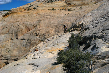
We came upon the rest of the group resting under the shade of a cedar tree. But it looked like they were finishing up, so Susie and I kept going. I figured that they would all catch up soon, at the speed at which I was going. And they did, but I was feeling pretty good, so I was able to stay with the pack. 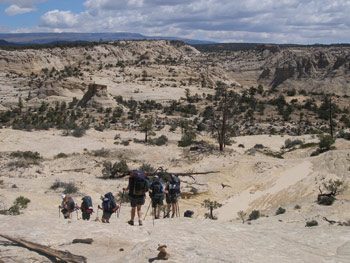 Will, who was not with us, had made the comment after hiking from the Escalante end of the BMT, that it seemed to be easier to locate the cairns if you were hiking from Boulder to Escalante, rather than the other direction. Since Susie and I had just covered this stretch, it was fresh in our mind. When hiking east to west (actually, NE to SW) finding the cairns had taken about zero effort. However, today, we were having to at least look around for them. So I think Will was correct: it is easier to follow the route hiking east to west. But either way, it certainly was not difficult.
We pulled into the campsite (the same one as Susie and I had used three nights previously) about noon. So it was a relatively easy 2.5 hours from Death Hollow to Sand Creek. I apologized for the size of the campsite and the roughness of the tent spots, but everyone seemed to like the spot, and had no problems with the closeness of one tent to another. None of the tent spots had all day solid shade, but every spot got some shade part of the afternoon. I think one attraction of the spot is that it was tucked away, and not visible from the BMT. Everyone seemed to want to save the "Honeymoon Suite" - a little tent site off by itself, about 100 meters up the drainage from where the rest of us were parked - for Will and Kim. Will always likes to be away from the crowd. 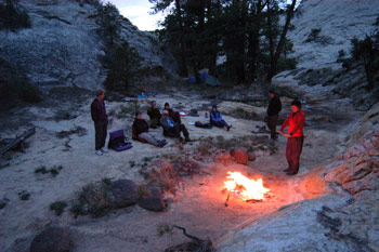 Susie and I noted that in three days, our sun-warmed pool had dried up, necessitating a bath down by the edge of the creek. When we got down to the creek later in the afternoon, we would also note that the water level had dropped a few inches. Susie and I relaxed in the afternoon, while most other folks went off exploring. Barbara would report that the vegetation was so thick along the creek bottom that trying to go downstream below the BMT crossing was too much like hard work. She also confirmed what we had noted a few days previously: that there seemed to have been a recent flash flood, which made for even more brush and disturbance. Will and Kim got to camp in mid-afternoon, and took off up Sand Creek. They reported that they got to the confluence with Sweetwater Creek and it looked to have a little flow of water and some nice grassy benches up there. Something to keep in mind for future trips.
After dinner, we built a nice fire down in the sand right in the bottom of the creek bed, so the next hard rain would wash the ashes away. Since this was the last night of the trip, everyone seemed to be willing to stay up just a bit later. It was a lovely, albeit cool, evening.
© Roger A. Jenkins, 2006; Photos of Roger climbing and hikers crossing slickrock,© Suzanne A. McDonald, 2006