
Upper Escalante/Boulder Mail Trail 2006
Two Halves Trying to Make a Whole
Back down the river
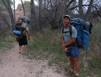
Tuesday, May 2 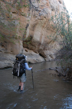 It sprinkled a bit during the night. But by the second time I had to get up, the stars were back out. Always a good sign. Most everyone was up and scurrying around like the mice we had heard all night. (Sue would report that a mouse chewed through her backpack.) Most everyone, with the notable exception of Will and Kim, seemed to be in the mood to mosey. I got a big hug from Sue. I think the unspoken opinion was that I might have, at best, a 50-50 chance of seeing the remainder of the crew before the very end of the trip, due to having to push my knee harder across the slickrock and being able to make the descent on the hard slick rock into the upper part of Death Hollow. I, on the other hand, was feeling pretty confident. I had done the 7.5 miles upstream in a day, and today would only be about half the distance. Or at least, that was the plan. Then, the plan for Wednesday was to hike out to the Highway 12 bridge in the morning, drive around to the Escalante town river trailhead, meet Will at 10:30 am, give him Barbara's medicine and the backup stove, and then drive around to the Boulder End of the Mail Trail, and hike in as far as Sand Creek.
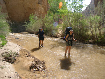
Susie and I took our time packing up, since we were only planning to get back down the river as far as the mouth of Sand Creek today. We were out of camp by 9:20, and rolling at a fairly good pace. My knee was rested and the sand was soft, the water in the river was clearer, but colder. I tried to keep positive and told Susie I was getting a lot of free icing down of my knee with all the crossings. Of which there were many.
We made great progress moving downstream, despite some occasional problems at finding the same crossings that we used on Sunday. Sometimes, you just have to make it up as you go along. We were able to make Sand Creek for a late lunch, and we started talking about the concept of going all the way out today. My knee was feeling pretty good, and there were both clouds building, with a threat of storms much greater than yesterday. In addition, there seem to be a fine crop of new hatched mosquitos hanging around the campsite just east of the mouth of Sand Creek on the north side of the river. 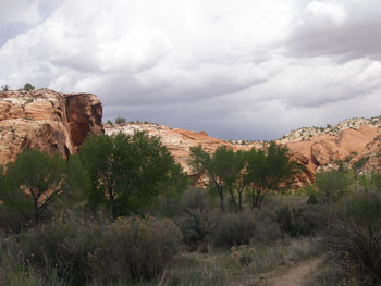 Our concern was that if we did have a major downpour, the river, especially given the amount of water brought in by both Sand Creek and Death Hollow, could rise quickly, and severely increase the amount of time it would take us to get to the Highway 12 bridge in the morning. Since we had to deliver Barbara's medicine and another stove for Will to the Escalante trailhead near town, any hold up on our part would also slow down the rest of the crew trying to make it over to the point where the Mail Trail Crosses Mamie Creek. So the plan, as it evolved while sitting at the campsite swatting mosquitos, was to freshen up our water supplies at the spring above camp (turns out that if you go upstream a bit further, it is even easier to get water out of the spring as it comes down over some high rocks), load up, hike out to the Highway 12 bridge, and hoof it over to the Calf Creek BLM campground and get a campsite. We figured we had a reasonable chance of getting a site, since we should be able to get there by 3:15 or so.
The skies continued to boil overhead, threatening to force me to put on some rain gear. I compromised by putting on a pack cover. The afternoon's entertainment, in addition to seeing the Escalante Natural Bridge from another angle, was provided by a couple of guys hiking upstream. 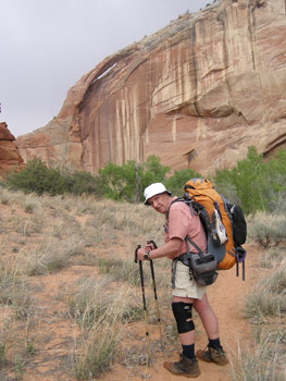 The lead fellow was from San Diego and pulling up the rear was a guy from eastern Colorado. They had met halfway, and were obviously out for a different kind of canyon trip. One fellow was hiking in sandals, and they both had massive packs. Like really massive. They had pork baby back ribs (hanging out the pack), bottled beer, a steel rib holder to broil the ribs over an open fire, and sleeping bags that seemed to have been purchased at K-Mart - in 1975!! We tried to explain to them where Sand Creek came in and where they could get water that was drinkable, but they seemed to have no map and little sense of where they were or where they were headed. But they looked to be having a good time, and as Susie pointed out as we hiked away from them, maybe they did not need potable water if they had enough beer with them!!
We reached the final crossing (of 30 in this 7.5 mile stretch) at about 2:20 pm, taking about an hour less to make the hike in this direction. We noted that the logs that spanned the river on Sunday, right at the level of the water, were now several inches above the water, indicating that fact was congruent with our impressions. The parking lot was totally packed, so we loaded up our gear and headed for the Calf Creek campground. As we pulled in, I am reminded of the signature phrase from that great TV show of the early 90's, Northern Exposure: "In your DREAMS, Fleischman!!" The campground was totally full and it seemed like there were hoards waiting to get in. Out here! In the middle of nowhere. So Susie and I quickly shifted to Plan C: a motel room in Escalante. This would have the advantage of making it vastly easier to re-pack our second half clothing and gear. We figured we could "motel camp," which, in this case, refers to cooking one's dinner that one had packed for the trail on a camp stove in the motel parking lot. Of course, having dinner at the motel would allow us to break into our stores of wine brought down from Bozeman, vastly improving the experience of ANY dinner we might cook.
 As we headed back across the Escalante, we began to formulate a modification to Plan C. Rather than wait until the morning to get the medicine and substitute stove to Barbara and Will, Susie would hike in from the river trailhead near town to where the crew was supposed to be camped, and deliver the materials now. That way, the crew, or at least Will, could get an earlier start, and so could we. Yeah, the weather was deteriorating by the minute, and squalls and sand storms were brewing, along with a thunderstorm, but Susie was willing to do it. (I had volunteered her only because with 7.5 miles under my belt today, I was not sure how much further the knee would hold out.) My contribution would be to run into town and secure a motel room, and come back and pick up Susie. As we dug through the huge amount of gear in our Highlander, trying to find Barbara's meds and the stove, the wind-driven rain started. What a delightful situation: here, Susie was taking off in a driving rain, headed to meet our group, despite not knowing if they would even be camped where I had suggested they camp (not too far downstream from where Pine Creek flows into the Escalante River. She took off in a hurry, telling me to be back in an hour. I wished her good luck and thought to myself: "Right, there is no way in hell she is going to be back in an hour. Not in this mess." I figured 90 minutes minimum, since we only had a concept of where they might be camped. And the weather was not being cooperative. I had dropped off Susie at the official start of the trail (12S,449032 E, 4180420 N), which is a quarter mile or so north of a larger parking area and the trail head registration/permit box. I would strongly recommend that anyone driving a low clearance vehicle stop at the register box area, park, and walk the last quarter mile. The rocks are sharp and ruts are deep on the aforementioned stretch. No need to punish your vehicle. (I was driving our Highlander and I did not want to drive the stretch again.)
 I headed into town, got a room at the Prospector Inn, unloaded some gear, stuck a bottle of wine in a waste basket, threw in some ice, chatted with our neighbors in the next room, who were hanging out, sipping some beer, waiting for the oil pan in their rental car to be repaired after blowing it out on the road into Egypt, and headed back down to the trailhead. I could not believe it, but I got there one hour after Susie had left, barely had time to take a waypoint, and here comes Susie. She reports that it had taken her less than a half hour to find the crew's camp. She had crossed Pine Creek, not finding any fresh footprints, and headed down river. Just past the aforementioned flow gauging station, very near where I had originally selected a potential campsite based on looking at aerial photos (digital orthophoto quads, available at the Utah GIS Data web site, she found the crew setting up camp. Terri, Barbara, Kim, Andy and Sue came running up to her, basically asking her what was she doing there. Of course, the answer was pretty obvious: "Delivering all the crap that you all forgot to or didn't take with you at the beginning of the trip!!" The crew was amazed that despite our proximity to the local pizza place in Escalante, we were opting for cooking a backpacking dinner. Anyway, she chatted for a few minutes, got a status report and headed back to the trail head.
 We returned to the motel, finished unloading the Highlander, took showers, and cooked a non-gourmet dinner of Lipton spicy beans and rice with some dried ham. Washing such down with a bottle of New Zealand Sauvignon Blanc made it seem a LOT better than it would have on the trail. Our primary entertainment for the evening was unpacking our dirty gear, and repacking new food stocks and clean clothes for the "second half" of the trip. Ultimately, we decided that doing all the re-packing was vastly easier in a motel room than at the trailhead. It would also mean that we could get an earlier start hiking in the morning. Or at least that is what we thought. But there are always some surprises waiting for you in canyon country........
Some of you may not be reading this for the story value, but for its "hiking guide" content. Sue Fischer graciously agreed to allow me to publish on the web her journal covering this and the next several days, so that readers could "follow the route" up the river and on to the Boulder Mail trail. So I have appended her comments at the bottom of the pages for the next three days. Her journal begins below:
Tuesday, May 2 Mouth of Death Hollow to Pine Creek
 It sprinkled last night but all was dry in morning. We ate a quick breakfast and packed up fairly rapidly. Roger and Susie headed back, down river, with Roger definitely favoring his knee. They plan on driving around to meet us toward the end of the Mail Trail where they will hike into Death Hollow from that end.
The rest of the crew took off around 9:00 am. It was a beautiful day of river crossings - water was a little lower and clearer than yesterday. Everyone enjoyed walking the grassy benches along the base of the very high sheer canyon walls covered with desert varnish. After about 1 mile, we came to a bend in the river with a small alcove over it - with pictographs and petroglyphs, as well as some evidence of vandalism and cowboy glyphs. The pictographs were simple, fairly crude affairs in red - a circle, an outlined figure and smudges. The petroglyphs appeared to be much older and were faint but of high quality. They consisted of big horn sheep, a Kokopelli and shaman-like things.
The day warmed up as we hiked on and we stopped several times in the shade for breaks and water, but then a breeze picked up - a perfect canyon country day and everyone was enjoying it. The river crossings became an anticipated way to cool off.
Further on we came to a large panel of petroglyphs - impressive and well done. Three shamans on the left, a string of big horn sheep going to the right, a stylized woman giving birth and a Kokopelli. This was a "packs-off" panel that required lots of pictures and 'oohs' and 'ahhs'.
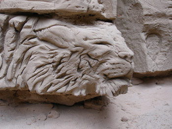 Further up the river we came to a meadow on the right, across which we could see a large ravine and high walls tucked behind slickrock hills. A very visible alcove in a far wall had 3 large shaman pictographs. Although several of us (Barbara, Teri, Robin and me as best I can remember) hiked up to the top of the slickrock hill, we were still a long way from the alcove. We decided that it would take several hours to get there and back, and we just didn't have the time. It would have been spectacular though. Will and Kim caught up with us at this point and having missed the good panel of petroglyphs, hiked back to find it (which they never did unfortunately). The rest of us hiked on for another ~40 minutes until we came to an enormous alcove on the immediate right of the river, which we figured was about 1.5 miles from where we intended to camp. We stopped for lunch in the cool shaded depths and admired the remains of 3 very large but also very eroded, shamans. Nothing else in terms of artifacts or glyphs were left in the alcove, unfortunately, although on the cut of the creek bank below the alcove was some really fantastic and phantasmagorical carvings in the hard dirt face, obviously done by locals (very talented locals).
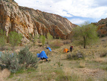 We hiked on and the canyon narrowed significantly and twisted around many times, which meant many river crossings - we were getting tired of them by this point. Dark clouds blew in and a strong wind picked up - and so did our pace. We figured we should have reached the designated camp site (supposedly on a creek coming in from the right) by 2:30 pm but at 2:30 pm we came on the Escalante Gaging Station. According to Roger's mark on the map, we had come too far. So we hiked back to where the GPS agreed with Roger's map (12S, 456657 E, 4190263 N) - no creek, no water other than the silty Escalante. There was a large somewhat sloping meadow that would afford camping so the group waited there while I hiked back past the Gaging Station to look for where Pine Creek and the Escalante join, in hopes of finding good water and good camping under trees. Found the junction but Pine Creek was as silty as the Escalante and there were no flat, clear (unbrushy) places to camp. So I hiked back to the meadow where we all pitched camp, briefly diving into tents because of a rain shower.
The weather and water quality meant no baths, but pumping gave us good water for dinner, after which we dove back into tents again because of the rain. After emerging in 10 minutes or so, we sat around until 9 pm admiring the stars that were also emerging from the fleeting clouds. We noted that we were definitely showing our age - early to bed and up only at 7 or after, not up at sun rise like we did years ago.
We crossed the river 24 times today.
© Roger A. Jenkins, 2006; Susan M. Fischer, 2006; Photos of storm clouds, Roger standing with pack, and pictographs © Suzanne A. McDonald, 2006; Group photo © William H. Skelton, 2006; Photos of river crossing, sand sculpture and campsite © Susan M. Fischer, 2006