
Upper Escalante/Boulder Mail Trail 2006
Two Halves Trying to Make a Whole
Descent into Death Hollow
Thursday, May 4 The most interesting thing that happened during the middle of the night was watching a bat when I got up to take a leak. There had been a few bugs out in the evening, hastening our retreat into the tent. Anyway, when I got up, probably around midnight, there was a bat flying around, eating insects. Interestingly, this bat would swoop down and pick up insects floating on the water (such as water striders). The bats wings would barely brush the surface of the water. Really neat to watch.
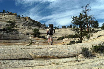 But so much for the night's entertainment. We awoke to a cool morning (ca. 41 degrees) and were up and out of the tent by 6:30. We were out of camp by 8:40 pm, deciding to enjoy the cool weather as we packed up. The BMT heads downstream just a short bit from the mouth of the drainage in which we were camped, and then turns away from the creek with a nearly 180 degree turn as it begins to climb a short, steep pitch. The route then levels out and continues to climb steadily. It is not hard to find the cairns and follow the route if one pays attention. Typically, the route follows the gentlest grade. It took us about an hour to make it to the top of the mini-plateau that "hosts" the Slickrock Saddle Bench. We stopped under the shade of a cedar tree, and studied both the maps and the hiking guide write ups.
Steve Allen's Canyoneering 3, which covers routes in the Escalante area, has an excellent description and map. I would recommend that anyone who owns the book use the map (on page 68) to assist with route "anticipation." Correctly, Allen describes the intersection with the Bowington Road coming in on the right, as the BMT prepares to make a turn to the south. 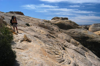 However, the Bowington Road is about the farthest thing from a road one can imagine. At the point of intersection, the BMT is a strong path through loose sand. Trudgingly loose. The Road is really just a path through the sand that is much fainter than the BMT. So the Road and the BMT become concurrent at this point and the BMT begins to turn south, heading down the Bench. While described correctly in Canyoneering 3, the map on page 68 is a bit misleading. The map suggests that there is a major turn in the BMT to the west, just before the Bowington Road splits off to the left. In fact, this is not correct. As the BMT heads more or less south, there is a small side drainage of Death Hollow which gets closer and closer to the BMT. This drainage is, in effect, the rim of Death Hollow. It just does not "feel" like a rim at this point. Anyway, at the BMT's closest approach to the rim, it makes a 90 degree turn to the right, and the Bowington road goes straight ahead and begins to gently climb. When we passed through on this day, there were two cairns on the BMT that encourage someone heading into Death Hollow to turn right. (However, when we came back, there was only one cairn, so pay attention.)
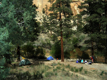
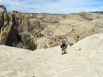 Ron Adkison's book, Hiking Grand Staircase-Escalante, has a good description of the descent (unlike its description of the start of the trail). We made the turn to the right, and sure enough, in less than a hundred feet, we were back on nice, firm slickrock. We descended, in alternating slickrock and sand just a bit, and stopped to take a pee break and take one more look at the maps before we began the "crux" of the descent. Susie said her arms were getting tingly, worrying about the descent. My sensitive, supportive response was something to the effect that I had been on lots of routes with her that seemed hairier than this looked based on the topo map, and she had handled them with grace and ease. I told her I saw minimal cause for concern. Like I said, sensitive and supportive, that's me. As described in Adkison's book, the route begins to descend relatively gently, along what is ultimately revealed to be a fin. As you get to the saddle of the fin, the route turns to the right, and descends, back on slickrock. The route jogs back to the left, out toward the edge of the cliff, and the "crux" becomes more apparent. Like Adkison says: the route at this point is not for the fainthearted. You are headed out towards a readily visible cairn, and there is nothing but air beyond. Nearly 500 feet of air. But it is tough to keep going, since the views are so spectacular. In many ways, more breathtaking than the Grand Canyon, because Death Hollow's sides are sheer walls from the rim to the bottom, and the canyon itself is very tight. This is true, National Park quality country. One of the things that comes into view as one approaches this cairn is the fine campsite that many of the guides mention. "Fine" is an understatement, especially if you have a big party with several tents. We are talking lovely sandy bench, dotted with huge Ponderosa pine trees, and clear water going right by the camp. It beckoned like the sirens in Ulysses. But of course, first we had to get there.
 It takes almost standing on top of the cairn before one can see the "solution" to the route. Turn sharply to the right, and see a path blasted out of the side of otherwise smooth, sloping slickrock. This, I concluded, was the place where the guides mention that the route had been "improved" so that horses could carry the mail. I was pleased that it looked much less worse than many other backpacking routes I had taken. "The crux" itself was probably only 100 meters (long) of exposure, and if you did fall, you would probably fall "only" 300 feet or so, but the route was perhaps 3 or 4 feet wide. So as long as one does not trip or stumble and lose one's balance, it is no problem. However, if you do trip ........ Well, let's just say it is a good idea to pay close attention to where and how you are placing your feet and you will be fine. I kept thinking to myself that this will be much easier when climbing out. Anyway, I went first across the blasted out portion, and encouraged Susie. As one might expect, she crossed it with no problem. From that point, one keeps working in a descending traverse to a small sub-drainage. You go down that a bit, and then turn hard to the left, and work your way across, always following the cairns and the shallowest route of descent. Eventually, you work your way over to the point that is below "the crux", and from that point, it is just switchbacking down the slickrock. You eventually get on dirt, and descend a few feet to some vegetation. Ahead is a small, single tent site on the right of the path, as it descends to creek level. However, the BMT turns left, pushes through some brush, and crosses the creek perhaps 100 feet downstream of the point where you first see the water. From there, it was a quick creek crossing (wet feet this time of year) and then into the fabulous campsite we had seen from just below the rim. It was 11:40 pm. We had done the crossing from Sand Creek to Death Hollow in three hours.
We dropped our packs, and looked around for a potential tent site. There were a lot from which to choose. I sat down and munched some snacks, and pondered our situation. The hiking guide descriptions seemed to be unanimous in their recommendations that THIS was the spot to camp (12S, 454455E, 4188328 N). I had asked Andy to be responsible for reminding everyone of this, in case the crew got strung out. (Was there any chance that they would NOT get strung out?). But this being a herd of cats, one could never be sure that any particular plan would be followed. (A good example was our own blowing off of a night at Sand Creek and coming all the way out. Priorities can change in the field.) So, since a) it was not even noon time yet and b) this was such a terrific place to camp that I really wanted everyone to get here, I took off downstream and told Susie to hold down the fort and I would be back in 45 minutes. I was hoping to get within striking distance of the spot where the BMT leaves Death Hollow, heading SW toward Escalante, and put a few markers in the sand, with some notes indicating camp was upstream. Ah, but this was my first taste of this section of Death Hollow. This stretch (as we would confirm the following day) is fairly rough. Once you get a couple of benches downstream of camp, the poison ivy takes over and there is no place to hike except in the stream bed. However, the stream bed is NOT like that a mile or two above the mouth of Death Hollow, which is relatively flat and easy walking. Instead, the stream is filled with volcanic boulders, that make the walking very tricky. Treacherous is a word that comes to mind. I was using both my trekking poles, to maintain stability in the creek bed, and it was a real challenge. Especially for one with a blown medial meniscus. I moved as fast as I dared, but it was not fast going. About 20 minutes downstream, there was a small beach, and I erected a small cairn, figuring everyone could see it, because no one would be foolish enough to challenge the sea of poison ivy on the benches. I put a small piece of paper with a note, indicating camp was upstream 20 minutes. I turned around, headed back, and erected a much larger cairn on a beach that you couldn't miss, with a note tucked into the cairn face (but still visible), indicating camp was now just 10 minutes away. (On previous trips, when I came across such notes myself, it is always morale boosting.)
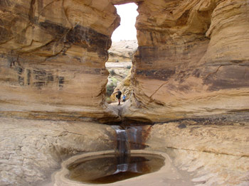
I got back to camp about 12:35 and indicated to Susie that I had never witnessed poison ivy like that which covered the benches just below camp. This was SERIOUS poison ivy. The woman at the visitor center had warned us, and the books all say the PI is unavoidable. Well, it is avoidable, as long as the water is low enough so that one can safely negotiate the stream bottom. But such would be tough to do if the water was much higher. Anyway, we enjoyed the shade of the pines for lunch, and I noted that Susie had moved our potential tent site over 30 feet or so. She liked it a little better, which was fine. However, we were reluctant to actually set up our tent until we saw at least part of the crew here. Instead of just cooling my heals, I decided to head upstream, in search of the so-called "spurting spring." This spring is reputed to have water actually rising vertically out of the ground, and it is supposed to be only 50 yards upstream of where the BMT crosses the water of Death Hollow, coming over from the Boulder side. Well, whoever did the estimate of 50 yards need to go and re-estimate: the spring is about 150 - 200 meters upstream of where the BMT first hits the water. Not that such is a big problem. But if you are looking only 50 yards upstream, you are going to be sorely disappointed. That said, the spring really does "gush" or spurt, or whatever. Imagine about 4 garden hoses, without nozzles on them, pointed vertically with the water turned on. Yeah, it is best to collect the water with a pot, and the water does have a faint metallic taste, but if you stay in the water upstream of the BMT, you can not miss it on your left. It is just a few feet above water level. It would be really nice to have water for the next couple of nights that did not have to be treated.
 Back in camp, Susie was just shaking her head with all my comings and goings. (She had the good sense to relax and read a book in the shade. Although in my absence, she had been doing some reconnoitering, and had located a large patch of the evil PI near our campsite, which needed to be avoided at all costs.) As it got closer to 2 pm, I re-read the hiking guides, and became a bit concerned, since one of the guide books indicated that camping was good right where the BMT hit Death Hollow coming in from the Escalante end. I decided that such might be confusing to the crew, because camping was excellent at the site at which we were sitting. So I took off back downstream to see if there was any sign of the rest of the crew. But this time, I did not get very far: a couple of benches below camp, I ran into Sue and Andy, who were heading toward camp with most of the rest of the crew in tow. Sue reported that there was no problem. They were heading up here anyway, but had found the cairns with the notes. They were just getting here, because they had decided to take a leisurely morning and day hike down to Mamie Natural Bridge. She also reported that Will and Kim were probably 90 minutes or so behind, since they tend to travel slower. But she alerted me to another problem they were having, or rather, Kim was having. (Now, Kim is the woman who hiked, for her second-ever backpacking trip, the infamous West Coast Trail on the west coast of Vancouver Island in Canada. Did I mention that she hiked it with what turned out to be a broken bone in her ankle? So when Sue said Kim was having a problem, I admit to being nonplused.) It turns out that Will is not allergic to poison ivy. So he just had not been paying much attention to it. And Kim, who has not spent that much time in the backcountry, did not recognize the three-leaf personification of nature's most prolific chemical weapon. So the two of them had been cruising the benches in Lower Death Hollow, oblivious to the potential problems for Kim. Well ....., apparently, Kim had streaks of poison ivy all over her body. (While she had walked right through the benches filled with it, the PI had probably gotten on clothing that may have been rinsed but not washed with heavy soap and water, and then transferred back to her body.) So now, Will was ahead of her on the benches, going slowly, and using his bare hands to break off the poison ivy stalks so Kim would not contact them. Oh brother!!
(A note here: despite the best intentions of the rest of us, virtually everyone had small places of poison ivy blisters on their legs or arms. For example, I had a couple of spots underneath my hiking shorts, and one long streak down my right leg. It seemed nearly impossible to avoid all of it.)
After we all (sans Ray, as he had, with his back and hip hurting him, decided to call it a hike at noon yesterday, and go car camping) got our tents up, I guided the crew up to the spurting spring, which takes all the effort that it might to guide someone to a coffee shop in downtown Seattle. But it was kind of fun to see everyone using different techniques to collect the water. After returning to camp, Susie and I went downstream a couple of hundred meters to clean up and just as we were finishing up, here comes Will. Kim was trailing behind a bit. Will reported seeing the cairns on the sides of the creek, and wondered what kind of idiot would put cairns in the middle of the creek, when it is the only way to go. He had not seen the note paper in the rocks.
John and the two couples and Robin sat around the remainder of the afternoon chatting and contemplating life, while Terri and Barbara took off, trying to get as far downstream as they could go, and still get back to camp before dark. They would ultimately report that as you get a ways down from where the BMT comes down from the Escalante end, the hiking gets easier, since the benches become poison ivy-free. Dinner for Susie and I was Lipton Broccoli and cheddar rice and pasta, with a couple of cans-worth of dried tuna fish added. Susie said that two cans was one too many and the concoction tasted fishy to her. My response was that something with tuna fish in it should taste like tuna fish, but I got no where. Except down to the trash fire we built along the creek bed (so that rain would wash away the ashes). As it got dark, the clouds built up and the sprinkles started. Such was enough of an excuse that most everyone dove for their tents. All the chicks that were supposed to be here were in the nest, and so things were as they should be.
Sue's experiences from the Mamie Creek drainage on are given below:
Thursday, May 4 Mamie Creek to Death Hollow Crossing
Up around 7 am (what else?), with all of us getting up at once, which was not surprising given the cozy tent situation. After breakfast we packed up but left our packs under the pines and dayhiked down Mamie Creek in search of the natural bridge that was supposed to be about 1 mile downstream. It was (12S, 453565 E, 4185681 N) and was very picturesque and a lot of time was spent crawling through it to the pour-off and photographing each other in it - except me because my camera quit last night.
We had planned on hiking further downstream, hopefully to where Mamie joins Death Hollow, but the pour-off was impassable and the cliff walls were too steep to traverse. So we returned to camp, had a snack and at 11 am started up, and I mean UP, the trail. Barbara's difficult part turned out in broad daylight to be not too difficult, although it took hands and feet to climb up. There was also lots of steep slickrock over the next 3+ miles, both up and down, as well as deep sand on the few flat areas. The terrain was much like yesterday and again there were plenty of cairns to guide us. 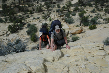 There were also long stretches of hiking under (or on in some cases) the old telephone wire that used to connect the town of Escalante with Boulder. We also saw a coyote running through one of the sandy flats, which consisted of sagebrush, juniper and a few pi±on, all sparse.
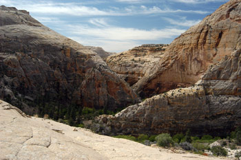
After more traversing of slickrock slopes we finally came to the edge of Death Hollow - what a deep, narrow canyon it is at this point! Standing at the cairn on the edge, it appeared that the wall below us was a sheer drop of 250'+ to the bottom, which caused us all to take a deep breath, but it turned out there were a series of switchbacks that got us down to the sandy floor by the gurgling creek without much difficulty.
We had lunch at the creek (nice clear water) and started hiking again upstream to where we would camp and meet Roger and Susie. 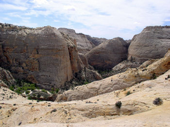 This part of the canyon is loaded, and I mean loaded, with poison ivy on the banks so we walked in the creek when possible. The canyon had a very lush and tropical look and feel, especially compared to the barren slickrock on top. After 0.5 mile or so, we came on a large rock cairn on a sandy 'beach' - with a note from Roger saying they were camped 10 minutes upstream. And in fact, as we hiked on, we met him coming back downstream.
® Roger A. Jenkins, 2006; Sue Fischer, 2006; Photo of Roger near cairn ® Suzanne A. McDonald, 2006; Photo of campsite ® William H. Skelton, 2006; Photos of hikers scaling slickrock ® Susan M. Fischer, 2006; Photos of Mamie Natural Bridge and Death Hollow overlook ® Barbara Allen, 2006