
Upper Escalante/Boulder Mail Trail 2006
Two Halves Trying to Make a Whole
The long and winding road
Wednesday, May 3 Susie and I were up before 6 am, packing and enjoying our trail breakfast, with a cup of motel coffee, which, incidentally, offered little competition for Starbucks, or even Folgers, for that matter. But it was caffeine, and such was tolerable. We headed over to the Escalante Visitor's Center, simply to get a weather report (highs near 80, 20% chance of thunderstorms today, 30% tomorrow) and then we off for Boulder, or rather, the Boulder end of the Mail Trail. It was easy to find the unmarked road (which is really the McGath Point Road) heading off the Hell's Backbone Road, about 500 feet or less after one turns off Highway 12. And, as the guidebooks say, the road is very rocky and rough. Be very careful if you have a regular car, as opposed to a higher clearance vehicle. We saw several cars parked in a little parking area out by Highway 12. They probably had decided that the access road was more fun than they wanted. After crossing a dirt airstrip in about a half a mile, the road pulls into the official trailhead area, complete with a sign and trail register.
 Susie and I loaded up and hit the trail by around 9:33. Since it was the most recent guide on the area, we were using Rod Adkinson's book: Hiking Grand Staircase - Escalante and the Glen Canyon Region. The guide clearly states that one follows the McGath Point Road, first to the southwest, as it follows undulating terrain, with great views, toward - what else - McGath Point. After about 1.1 miles, the guide says start looking for an old double track jeep road that leads off to the right. If one bothers to look at the map, and compare it with the scenery, it is pretty clear that the route that leaves the road and heads SW into a drainage that leads toward Sand Creek, just below its confluence with Sweetwater Creek. Well, as the Hertz RentaCar commercials used to say: "Nottttt exactly."
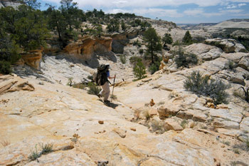
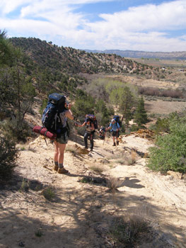
Susie and I were moving along pretty good, as we headed out the McGath Point road. In some places, it was clear that one would really need a Jeep to drive the road. Certainly, I would not want to drive it with any vehicle we own. But it made for easy and fast walking. Just a few minutes after 10 am, I told Susie that since the old jeep road leaving the McGath Point road was 1.1 miles out the latter, we needed to start looking for it. So we kept on motoring and looking for a marked turn off. After about 45 or 50 minutes, having seen nothing marked as the trail, I said we needed to stop, take a GPS reading, and see where we were, and where the trail was supposed to be. Now, a note here. The Boulder Mail Trail (BMT) is marked on the National Geographic Trails Illustrated map called Canyons of the Escalante. The scale of this map is a little bit too coarse for my tastes in hiking. So I had carefully studied the map and the topography, and had transferred the route to my 24,000 scale TOPO! (www.topo.com) map of Utah. Having done this before, I have found I can usually do a fairly good job of accurately transferring the information. OK, so we turn the GPS on, and wow, did we overshoot the turn off. Like, by nearly 3/4 of a mile, based on my translation of the point where the BMT intersects the McGath Point Road on the TI map. Apparently, we had been moving so fast out the road that by the time we had started looking for the turn, we had already passed it. Susie made a justifiably snide remark about our needing to get more miles on our boots today anyway, given that we had decided to only go as far as Sand Creek (she was concerned about the phrase in the hiking guide indicating that the descent into Death Hollow was "not for the fainthearted" and she wanted to do that earlier in the morning when a) we would be fresher and b) the threat of thunderstorms would be lower). I think there were also some comments about my gimpy knee, but in general, we both took it in pretty good stride, perhaps focusing on the speed that we were making hiking back north on this road (something like 2.8 miles an hour - based on the GPS, which is pretty good for carrying a backpack).
 We arrived at the point where we were supposed to take off to the SW, and noted that the waypoint that I had transcribed was nearly 500 feet off the road to the NE. It would not be the first time that I was standing on a trail, and the GPS showed me off the trail, indicating, in fact that the trail had been mapped incorrectly. Well, we frogged around for 15 minutes or so, looking for a large pine tree near where the turn was supposed to be (there were quite a few pine trees out on this plateau). Eventually, we settled on a single track path, with a lot of brush piled in front of it, that was near the spot where a track SHOULD have turned off to the SW, and took off. We figured, hey, how far can we be off here. So as we headed down this single track, it expanded into a real double track old road, just as the hiking guide describes, and then contracted into a single track. The single track continued to head toward the SW, and at one point, I stopped, turned the GPS on, and asked it to show me the nearest waypoints. The one that I expected to be near, based on my translation, was only 50 feet away. Hard to do better than that. As we continued down the steep path, we noted that the path was filled with old brush, as though the land managers had not wanted people to use this path. Hmmm .....
 Eventually, we got to a point where our partly-obliterated path T-jointed into a much stronger path coming down from our right. The large number of fresh foot prints indicated that this was the "real" trail
So we turned left on the "real" trail and practically tripped over a sign on the side of the trail, pointing to the trail which had come in from our right, directing people NOT to take the trail we had been on. We vowed to use the GPS tracking feature when we passed by here again, to determine where the new trail went. Clearly, it was going nowhere near the route described in the hiking guide. We would later learn how far off we had been, and why we were not on the new route. (Hint: thank the BLM for directing us the wrong way, and we have proof.)
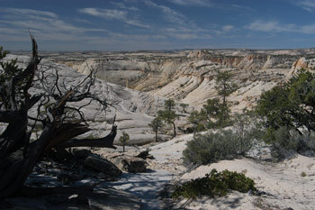
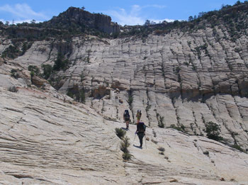
OK, it was 11 am and we had made at least 40 minutes worth of real progress. But we were on the correct route now. Following the cairns was pretty straightforward from this direction. All the guidebooks say that they are easy to follow, and on this score, they were correct. Susie and I stopped for a rest/breakfast bar break about 11:30 and decided we would push on down the drainage toward Sand Creek. I had to admit that the views were really breathtaking. I had never hiked on such a huge expanse of slickrock previously. It went on for square mile after square mile. Yeah, you see the pictures, but the photos do not do it justice. It was hard to pay attention to where your feet were going, but pay attention you must. In a way, the hiking appears deceptively easy and there is the sense that because the footing is so firm, that you are hiking on a side walk. Until the sidewalk drops a few inches unexpectedly.
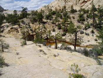
We got to the crossing of Sand Creek at about 12:30. Don't expect to keep your feet dry this time of year. There is one step that must be made with your boot submerged as you make the rock hop. If you have big feet like I do, you might get lucky and have the water stay below your ankle openings. Susie, being pretty small, especially her feet, was not so fortunate. The guidebooks say there is good camping near the crossing, and indeed there is a lot of flat terrain on the west side of the creek. But it also offered little shade, but if you have a large group, you might look for something a tad better. 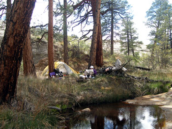 Susie and I ate lunch in the shade of a juniper, feeling the heat build up as we contemplated our options. It was early in the day, and we had time to look around and see if we could find something better. Alongside the creek is not an option in this area. The slickrock is shallowly sloped down to the water level, and the stream is choked with vegetation. Simply few places flat enough to put up a tent. We decided to look around, leaving our packs in the shade to claim the spot if needed. We headed downstream as far as the point that the BMT leaves the creek bed and starts to climb out of the immediate drainage. Nothing there really, except a nice place to get down to the water. So we turned around and headed back upstream. Then, I noticed a drainage coming in from the NW, that, according to the guidebooks, was dry. However, there was a brown pool near its mouth, and as my eye went up the drainage, I could see tall Ponderosa Pines back a ways. Susie and I decided to explore it, and upon further reconnoitering, we decided we had found home for the evening (and maybe for our group in a few nights). The spot (12S, 456657E, 4190263N)was really not visible from the trail, had nice pine trees for broken shade, and right now, it offered a sun-warmed, albeit stagnant pool surrounded by nice clean slickrock, near perfect for bathing. Life was GOOD in canyon country. Of course, no such thing as a totally free lunch: most of the possible tent sites were lumpy, but that is what extra clothing is for. Ultimately, this turned out to be a pretty terrific site. Sometimes, you get lucky.
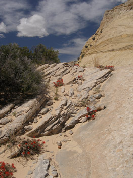
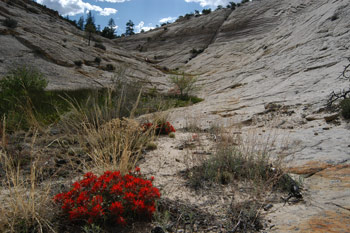 Susie and I headed back to pick up our packs, but decided, just for the dickens of it, to check on an area upstream of the crossing of Sand Creek. We could see Ponderosa Pines, but it turned out to be on the far side of the creek, where the crossing would be particularly difficult, and I could feel a horrible case of the "lazies" coming on. So we returned to our packs, hoisted, and headed back to our new home for the night, with visions of a warm bath dancing in our heads. And warm it turned out to be. It was not like a hot shower, but it was as close as it gets in a place where the evening temperatures were dropping into the 40's. And nice to be able to stand on clean rock. After bathing, and water pick up, and doing some relaxing reading, I did a very conservative exploration of the drainage in which we were camped. Lots of paintbrush blooming and slick rock. There was a tiny trickle flowing down the drainage, just enough to count as water flow. We cooked dinner - beef stroganoff - on the rocks, but were chased off by the sun coming out and blasting us with an early evening reminder of its intensity. We read some more after dinner, crawled into the tent for a "slide show" before it got completely dark.
Sue's experiences for the first day of the Boulder Mail trail begin below:
Wednesday, May 3 Pine Creek to Mamie Creek
The sky was clear when we got up, but it must have rained upstream more than where we were because the river was up and very, very silty. Had to let the water settle quite a bit before pumping and had to use a coffee filter around the pump to keep it from clogging. Ray decided he would day hike a ways with us and then retrieve his gear and hike on into Escalante.
Putting wet, cold boots on again was not all that pleasant but it had become the norm on this trip. We packed up and hiked up river to the Gaging Station, then crossed Pine Creek, which was roaring and thigh deep. The trail up Pine Creek crisscrossed many times (9 crossings today) before reaching the spot (12S, 448763 E, 4181846 N - note: this is much further downstream along Pine Creek than what one might extrapolate from the Trails Illustrate Map: Canyons of the Escalante) where it takes off straight uphill, up steep slickrock.
The day was spent alternating between hiking on huge expanses of slickrock - usually steep up or downs - and sandy, sagebrush covered flats. The elevation was 1000' higher (6600') then where we hiked along the Escalante and this occasionally afforded some good views of distant ranges. There were numerous cairns on the slickrock so we didn't have to do much route finding. The broad expanses of slickrock and general high openness of the terrain were in stark contrast to the narrow canyons of the past few days. Although the sun was hot, there was a cool breeze and the air was dry. We stopped frequently for shade breaks under Junipers, or in some cases, in sandy depressions under Ponderosa.
At lunch break Ray turned back - he had decided to drop out of the backpacking part of the trip due to his aching back and ankle. He plans to hike back to where he left his tent and gear in the meadow last night, then hike out and the spend the next few days dayhiking.
We dropped down (a long way down) into Mamie Creek and arrived at the creekbed around 3 pm. The creek consisted of several large pools of water separated by lots of beach-like white sand. We found a small brush-free flat area under Ponderosa pines to set up tents - it was cozy! We all bathed - felt wonderful, and our rinsed out T-shirts and underwear which dried almost immediately.
Dinner was a quiet affair - it was just not the same without Roger and Susie or Ray. We all felt cool and put extra clothes on - even though it was 69 degrees (morning low was 41).
 After dinner Barbara wandered up the slickrock 'hill' where tomorrow's trail would take us - she came back with the report that the section near the top was very steep and would be scary with packs on. This was not something anyone wanted to hear. We all went 'in tentia' at 9 pm, as usual; no rain showers tonight.
© Roger A. Jenkins, 2006; Susan M. Fischer, 2006; Photo of paintbrush and sitting in camp © Suzanne A. McDonald, 2006; Photos of hikers © Susan M. Fischer, 2006; Photo of Pool surrounded by slickrock © Terri Cox, 2006