
Upper Escalante/Boulder Mail Trail 2006
Two Halves Trying to Make a Whole
Narrow Slots and Wide Washes
Monday thru Wednesday, May 8 - 10 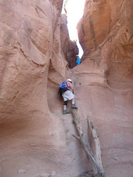 To say we were unprepared for our experience for slot canyon hiking is, like, the understatement of the millennium. Sure, I have done a fair amount of canyon hiking: something like over half a year of my life spent hiking the canyons of the Colorado Plateau since 1980. I had hiked in narrow canyons: Buckskin Gulch, for example, and even the Joint Trail in Canyonlands NP. And I had certainly read about Peek-a-boo and Spooky Gulches. But reading about them and dealing with the reality is two different things.
We left Escalante a bit after 8 am and picked our way down 26 miles or so of Hole-in-the-Rock road. The road had been supposedly graded recently, but that was a joke. It sure seemed like 26 miles of washboard to me. And the road into the Parking area at the head of the Dry Fork of Coyote was even more interesting. Huge ruts. The kind you have to be careful about when placing the wheels of your high clearance vehicle, lest you tear up its underside. We arrived at the trailhead at 9:15, immediately after a family from Woodland Park, CO. Paul and Janet and their two boys (Brice and Brett??) turned out to be our saviors during this trip. We left the trailhead and started down into the Dry Fork right ahead of them. Having hiked in narrow canyons before, I decided to bring my tripod, in case the light was limited for photography. Big mistake. I also had my full size day pack with me, with lots of water, and polartec, in case it was cold in there. Another big mistake. (Note that there are a lot of good maps and route descriptions on the Internet: http://www.americansouthwest.net/slot_canyons/index.html; http://www.canyoneeringusa.com/utah/esca/index.htm; http://durt.org/esc2003/.) So I will focus on just the "experiences" we had.
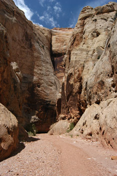
 The descent off the Dry Fork rim was pretty straightforward. We just followed the well-worn path and rock cairns. Once you get out on the rim, it is pretty easy to see the mouth of the Peekaboo slot. Now, we had not spent a lot of time researching the route, and so I was a bit taken aback when we walked down the Dry Fork to the mouth of Peekaboo. You see, the mouth is not exact at the level of the floor of the Dry Fork. Rather, the actual entrance to the slot is about 20 feet above floor level. Someone had placed a small tree trunk against the canyon wall. This enables one to use the knobs on the trunk to climb to a rock shelf. From the rock shelf to the floor of the slot, one has to rely on Moqui steps which have been cut into the canyon wall, and friction to get up into the slot. I went up first (Paul and his family were already up in the slot), in a very unglamourous manner: pulling myself up so that the lip of the slot was about chest high, then tilting over on my chest and slithering my way so that my body was on the floor of the slot. Think "beached whale" here.
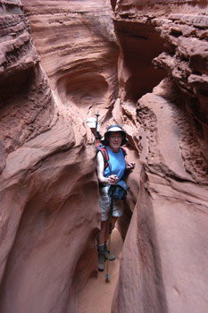
I was able to provide some assistance to Susie and Barbara, who needed much less than the uncoordinated, knee challenged author. But mostly, it was Paul and Janet's encouragement that got us up. I was, of course, thinking: how are we going to get down from this? That problem would be solved later. Once up to the first level, we walked on flat, narrow bottoms, crawling under small natural bridges for a short way, and then had to pull ourselves up another short wall to get into the long stretch of narrows. I was not mentally (or gear) prepared for the narrowness of the slot, and got plenty dirty quickly. The tripod on my pack was a real liability. My relatively large daypack was as well. Many times, I was having to take off the pack, and drag it behind me. It was fun, in a perverse sort of way. But there was no question as to the beauty of the slot. We pushed through the slot, contorting and taking lots of photos. I really wish that I had taken more time to set up more artistic photos, but for some reason, the combination of the sense of having bit off more than I probably wanted to chew, plus impending doom, forced me to move more quickly than I wish I would have in retrospect.
 From the mouth to a spot where it is possible to climb out, it might be a short 2/3 of a mile. We got to the opening, and Paul, who was way ahead of us, had come back and yelled down that the section ahead was too narrow to reasonably hike, and after I tested it, we agreed. The floor was so narrow that one really could not put one's foot flat on the slot floor. I figured trying to go a couple more hundred meters with my knee further twisted and challenged could not be good, so we climbed out. Paul guided us over to where Janet and the boys were waiting patiently in the shade of a juniper and suggested that we join them, and hike over to the head of Spooky (since they knew the way), where they could lead us down the slot. Sounded like a plan to us. We drudged through about a third of a mile or so of loose sand and all stopped in some major shade to eat lunch and prepare for Spooky.
After lunch, we headed down the broad wash that feeds the upper end of Spooky. The first challenge was a short stretch of slot in which it was impossible to put one's foot flat on the sand floor. Not too bad, since a couple of feet above the floor, the slot broadened out a bit. Next on the list was a large choke stone and a 12 foot down climb. At this point, we had a couple of choices, and we opted for the one with less exposure but more sliding on our butts. Paul stood by to direct and it was a great help. The young boys also helped by moving our packs, cameras, etc, to the next wide spot on the canyon floor. We could have done it on our own, but it would have been even more work. We all made it down just fine, albeit with more scraped flesh. After the downclimb, you get an easy stretch for maybe 50 meters. And then there are a couple of things that Paul referred to as "corkscrews." Essentially, one has to friction slide and twist at the same time, essentially corkscrewing down to the floor of the slot. One of those places where a "virtual" step or foot hold from the person below you can be a huge help. I would not wanted to have done these totally on my own.
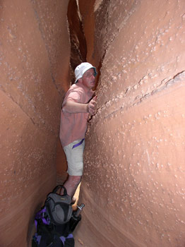
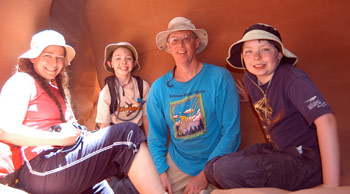 The final challenge in Spooky is a stretch of extreme narrows. This is the spot where you see a lot of photos taken of people squeezed between two canyon walls so close together that they can barely breathe. I do not have a huge chest for a guy: 43 inches. But I am more "barrel-chested" and for me, this was a SQUEEZE. Essentially, I would push forward a few inches, exhale as much as I could, stop, try to inhale, then exhale and push forward a few more inches. If one is claustrophobic, this is not the place for you. I was not sure it was the place for me. I endured, but it was tight enough that when I emerged from the tight spot, I realized that I had lost 4 of the primary buttons on my canvas shirt. Of course, Susie and Barbara, being vastly more svelte than me, made it through more expeditiously. We wrapped the whole thing up watching a neat lizard clinging to the slot wall with the boys. Paul and Janet invited us to continue down the Dry Fork with them, as they tackled some chokestones down canyon. We decided to pass on that a) because we had enjoyed plenty of fun that day and b) it was already 1:30, and we figured it would take an hour to get back to our car, and another hour to drive back to town, and c) it was getting very hot in the sun. We thanked them profusely, promised to send them some digital photos and headed back up canyon, skinned elbows, ripped shirts and all.
We were back in Escalante by 3:45 and headed to the Escalante Petrified Forest State Park. Now, out here in the desert, it is hard to think in terms of "forest," but the campsites had some shade (and showers), and offered a nice trail through some interesting petrified wood. Dinner was pesto cavatapi and chicken with some Chardonnay and beer and what ever else we could scrounge up. Susie and Barbara returned from their hike up in the petrified wood (after the slots, I had decided my knee had had all the fun it wanted for the rest of the day) in the dark, announcing that they had decided (I was clearly out-voted) that we would get up early, blow off breakfast in camp, and on our way over the Capitol Reef, stop at - you guessed it - the Hell's Backbone Grill for a more civilized repast. Who was I to argue?
 So the next morning, we were up at first light and rolling out of the campground by 7 am. It was good to be packed up early, since the skies had clouded up and were threatening some rain. We arrived at the Grill at 7:45 am, about the same time as the raindrops. It felt good to be inside, being served great coffee and food on a cold, damp morning. I had the French Toast, Susie had the Backbone Breakfast, and Barbara had some southwestern egg spicy concoction that was delightful. She decided to add a pastry to go, but managed to down most of it before we walked out the door. The food and coffee is not cheap, but it is wonderful and worth every penny. You can't go wrong.
We headed over Boulder Mountain toward Torrey in light snow and snow mixed with rain. Not an auspicious start to the day, but by the time we got to the outskirts of Torrey, we could see that the trailing edge of a front was about to pass us, and sunshine, blue sky, and cooler temperatures would be close behind. We pulled into the Park campground at Fruita, and felt like we walked into a Garden of Eden in the middle of the desert. The area was a spot where Mormon settlers had established orchard and farming communities, and the campground was grassy and shady, and surprisingly, hardly full (at this time of the day: 10:45 am). We set up our tents, paid our fee, and headed south along the scenic road and turned into the Grand Wash parking area. Grand Wash is a pretty hike: about 2.2 miles each direction. It has some narrows as it cuts through the reef that comprises the major geological feature of Capitol Reef. The narrows are lovely and the walls high, but frankly, it is tough to hold a candle to the walls of Death Hollow. The hike is pretty much gravel (no water flow most of the time), but if you are looking for an easy hike with some soaring canyon walls, this will surely fill the bill.
Next, we headed down the scenic road further south, acting like tourists, and returned to camp and took make shift showers by heating water with our stoves, and either cleaning up in the bathroom or tents. Cocktail hour was declared, and we settled into a period of relaxation before dinner. In the go go go of the last 10 days or so, it felt good to do practically nothing. 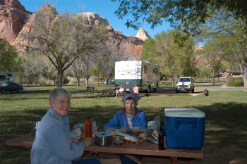 We noticed that the small RV next to us had a Gallatin County (MT) license plate and we talked to the occupants, learning that it was a couple (Dave and Jennie Milne) who lived on the south side of Bozeman and that he was the outgoing head of the local Audubon Society chapter. Small world. And yet another example of why one has to be on one's best behavior at all times.
The final, or what should have been "final" morning of our trips, consisted of lazing around camp, doing a bit more sightseeing, and then heading back to Salt Lake. Our plan was to drop off Barbara at the airport after shopping at REI in Sandy, and then head for Pocatello, ID, returning to Bozeman by Thursday noon. We did not hear from Barbara for a few days after we got back. Apparently, the airlines did not cooperate with her plans, cancelling her flight out of Salt Lake, putting her up for the night, sending her to Chicago, where it was delayed flight hell. After cancelling her flight to Denver, they put her on a flight to Nashville where she arrived at 2 am Friday. All rental cars were booked out of Nashville, and the Nashville to Knoxville Van shuttle had gone belly up, so a nice young Marine heading to North Carolina gave her a ride the last 175 miles to Knoxville. She arrived home at 1:30 pm, sans luggage, over 50 hours from the time we pulled out of Capitol Reef. It was surely the trip from Hell. At least, the non-canyon hiking part.
© Roger A. Jenkins, 2006; Photo of Roger climbing tree ladder © Suzanne A. McDonald, 2006; Photo of Roger squeezing through narrows © Barbara Allen, 2006