
Upper Escalante/Boulder Mail Trail 2006
Two Halves Trying to Make a Whole
Out
Sunday, May 7 I was out of the tent before the appointed hour, which, in this case, was 6:30 am. We had planned to roll at 8:30, so the 8 of us headed back to Salt Lake City could arrive there at a reasonable hour. Unfortunately, nature was calling, so I got a head start on my 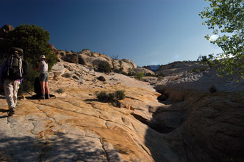 day. Despite my best efforts to be quiet, I think my stirring got others in the mood to pack up. We packed up quietly, so as not to disturb Kim and Will in the "honeymoon suite." I think Susie and I were underway by 8:10 am or so. Barbara had left a few minutes ahead of us. We went out the Mail Trail and turned toward Boulder and climbed up on the bench that sits above the stream bed. I crossed the creek with Robin and Susie. The two of them stopped not too far after the crossing to remove wind shirts. While the morning was cool, the sun was warming things up quickly. I had left camp in my hiking/climbing clothes (ie, no wind shirt, jacket or what have you), so I just moseyed up the slickrock, taking my time. I made the first turn to the right out of this drainage, and thought I would wait for Robin and Susie, and take some photos as they climbed toward me on the expance of white slickrock. Well, I waited and waited and waited. Nothing. After 15 minutes or so, I figured someone might have slipped crossing the creek, and we might be back to shades of the Beartooths in 2002. So I took off my pack and headed back down into the drainage, just to see what was going on. The answer, I guess, was "Not much." When I got down to within shouting distance of Susie, she indicated that John had taken off his pack to put away his jacket, and got a bit behind. Then, he could not find the way off the bench down to the creek crossing. Apparently, they were trying to guide him to the correct spot by yelling directions, clearly without success. This must have been a hoot to watch for a couple of guys camped up on a small bench to the south of me.
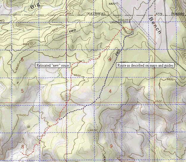
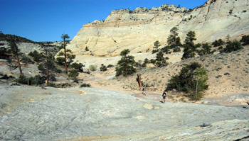 After that delay, I was pretty well rested, so I continued to follow the cairns and let others catch up and pass me. We eventually got to the spot where Susie and I had come down (from our right now) off the old trail and picked up what had to be a relocated trail. In anticipation of this, I had turned on my GPS while I was waiting for Susie and Robin, and had started tracking the route I was following. The new route climbs first through soft sand past the marker that says "Trail", but the sand quickly firms up. Eventually, it gets to the general elevation of the plateau, and undulates over the terrain. In some cases, it is undulating a half a mile west of where the National Geographic/Trails Illustrated Canyons of the Escalante shows the trail route. If you click here, you can see (and save) a Gif file of the newly relocated route vs the route marked on this map.
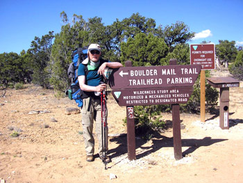
I was hiking as fast I could with this knee, but eventually, Susie told me to get out of the way, as I was holding up progress. So much for sensitivity. When we went around Robin Hood's barn, so to speak, to get to the trailhead (about 5 minutes behind everyone else), we now understood the problem. Check out the photo on this page. The BLM sign indicating the direction is misleading, at best, and downright incorrect, at worse.  The arrow on the sign points to the trail direction? Or maybe it is pointing toward the parking lot? As it turns out, the trail takes off right behind the trail register (there were no signs when we hiked the route in May of 2006. Maybe the BLM can work on that, if they are not too busy issuing oil drilling permits in Wyoming.) In addition, Andy and Will graciously permitted me to use the waypoints they took along the hiking route, so that we could reconstruct a real route for the trail. You can click and download a PDF file of the south end of the trail here, the middle here, and the north end here. (Note that the waypoints are in NAD27 grid.) The actual waypoint values are found in this comma delimited text file. As far as we know, this is the first time that a ground verified-by-GPS route has been published on the web. (DURT.org has some trail maps published at http://durt.org/esc2003/ However, these appear to be planned routes, as opposed to verified routes.)
Ray was at the trailhead when we arrived, looking fit and happy. He had a good time doing a little exploring and hiking in the canyons locally. And eating breakfast at the Hell's Backbone Grill. He recommended their breakfast, and Ray is a real breakfast person, so that was saying a lot. Ray took John back to the Highway 12 bridge so they could pick up John's minivan, while Susie and I chatted a bit longer to our friends, most of whom were getting ready to head back to Salt Lake. But not too long. Will was getting itchy to get to the Grill before they quit serving breakfast. 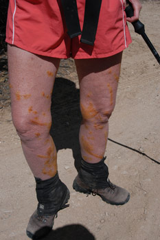 And speaking of itchy, we all stood around taking photos of Kim's legs, streaked like crazy with poison ivy damage (she had used crushed iodine pills in a water suspension to reduce the impact of the contact toxin once the streaks started to show). But of course, this was only the stuff she would show us. She reported that she had lots more spots all over her privates that she would be unwilling to have posted on the Internet. Sheesh!! Some people.
So the crew took off in the proverbial cloud of dust, leaving Susie, Barbara and I to entertain ourselves for the next few days. We did not figure such would be too hard in canyon country. But first, it was time to squeeze into the stuffed Highlander and head back to Escalante for lunch and a shower. Now, understand that Escalante is the epitome of Mormon Country, and it is Mormon tradition to keep many non-essential businesses closed on Sunday. I certainly respect such, but it does make it hard on a traveler. However, Escalante Outfitters seems to be a shining example of the triumph of capitalism over tradition in order to assist the weary traveler. In addition, they serve BEER and WINE. On Sundays. We knew where WE were headed for lunch. Now Escalante Outfitters is not just a sandwich and pizza place. The sell art, clothing, hiking gear, etc etc., and they have to be your number one stop in town. Maybe more important than the Interagency Visitor Center. Did I mention they serve BEER? The three of us descended into the restaurant section (which is like 5 tables) like a plague of locusts. Bread sticks with marinara sauce and grilled chicken Caesar salads seem to be the order of the day. And BEER. Life was good. We chatted with the new co-owner of the place, who had recently left corporate America to be in the canyon country. Escalante is a long way from everything, but sometimes, that feels just fine. Anyway, it was a bit early in the day, so he had time to chat with us, which added to the homey atmosphere of the place. I reflect back to our first visit to the town, in 1980. I know that many Utahns abhorred the designation of the Grand Staircase-Escalante National Monument, but it was the right thing to do, both morally, and economically, especially the small communities that are on the fringes of the Monument. It has made a clear difference. Yeah, there are more people in the backcountry, for sure. But as government-subsidized cattle grazing becomes increasingly unpopular, the designation of the Monument has cushioned the economic blow. It is ironic, in a way, that Escalante Outfitters offers free high speed internet access from a computer in the restaurant, and Susie and I can not even get such where we live in Bozeman.
 After lunch, we checked into the Prospector Motel (for Susie and I, the third time on this trip), and, after hot showers, piled all our dirty laundry and headed for the only laundromat in town. Unfortunately, the laundromat is both hard to find, and not well kept, but it was the only thing available. The bright side was that we met the campground host for the Escalante Petrified Forest State Park. She was there doing her laundry and mentioned that if we were going to be car camping for the next couple of nights, the campground was a nice place to do it. A plan was starting to evolve. This was good, because we had deliberately left this part of the trip pretty loose. Barbara had to be back in Salt Lake by 3 pm Wednesday to catch a plane east, but that was our only constraint. We had wanted to do some slot canyon hiking, but there was more than a little concern about how much longer my knee would hold up to these desert tortures. But now things were clarifying, and the plan was developing: we would drive down Hole in the Rock road, which had been supposedly been graded recently (Yeah?? NOT!!) to Peek-a-boo and Spooky Gulches for slot canyon hiking, then drive back into Escalante and stay at the State Park. From there, we would head over to Capitol Reef National Park (neither Susie nor Barbara had ever been there) and maybe take an easy day hike on Tuesday. Our neighbors in Bozeman, Dick and Jan, had recommended staying in the Fruita Campground and hiking Grand Wash. Hey, why not. Then Wednesday, we would drive back to Salt Lake, do a bit of shopping before dropping Barbara off at the airport and heading back home.
After the laundromat, we headed over the Visitor's Center to see what was up (basically, relaxing and killing time). Being mid-afternoon, when most folks are out hiking, it was pretty quiet and so I struck up a conversation with the young man manning the desk (we think he was the same fellow that was so helpful to us last year, as we had to change our hiking plans at the last minute. I asked him specifically about the stream water flows, and why, when we showed up the previous Sunday to start hiking with water flow at 58 cfs, the person at the desk said that the water would be high, whereas, with a couple we had run into mid-week, who were told that the water, (it was flowing at something like 63 cfs that morning) was really too high to hike safely. I observed that the distinction between 63 and 58 cfs was pretty small, less than 10%, and whether the BLM may have an arbitrary set point (eg, 60 cfs) where they recommend that backpackers and hikers not attempt going up the river. Well, the young man, who seemed pretty open and articulate, opined that first, some of the supervisory staff at the Visitor Center are pretty uptight about water flows in the river and that secondly, the placement of the water gauging stations (mentioned in Day 1 of this report) makes guessing pretty tricky.
He also lamented that it is very tough to get reports back from the field from hikers as to what their experiences have been, so that they can compare those to known factors like water flow. Most people stop in the visitor center prior to their trip, but not after their trip. I told him that based on our experience, 58 cfs, while high, was no problem. Even the short people on the trip were never in danger of "floating" (having the water get to the bottom of their backpacks and beginning to lift them off the river bottom). I pointed out our TwoHikers.org web site, and showed him how he could go back and compare dates and experiences along the river to water flows. Barbara, Susie and I went on to other things, and when I returned to the desk, I could see that he was reading reports in the Canyons section of this website, and in particular, he was reading the story about Ranger Lynn. He said, "You know, I think I have read this before!" "Someone came in here a couple of years ago with the article on Ranger Lynn that had been written up in some newsletter." I pointed out to him that it was a good example of why you always need to be on your best behavior, because the person to whom you are talking might end up communicating his or her experience to a much wider audience than you had ever considered.
Dinner was pizza at Escalante Outfitters: one vegetarian and one chicken pesto. Even without a couple of the ingredients that the owner confessed that they were out of, it was still pretty good. We deliberately ordered more than we would likely eat that evening, thinking lunch the next day. The Outfitters was a pleasant place to have dinner, and likely one of the few places in town. (It was not clear that the grocery store was even open on Sundays, so it would have been tough to cook something in the motel parking lot.) We looked at an open art shop next to the Outfitters. Their rugs were really lovely and reasonably priced, and if I could have figured out how to use them in our home, I would have bought a couple. We sat outside watching the sun set, appreciative of some clean clothes and full bellies. Life was good in Canyon Country.
© Roger A. Jenkins, 2006; Trailhead sign photo © John Finger, 2006